Category: AT Daleville VA to Big Stoney Creek

  • Day 3 – Four Pines Hostel to Campsite (mile 691 NOBO)

    Day 3 – Four Pines Hostel to Campsite (mile 691 NOBO)

    Today’s Miles: 8.73

    Trip Miles: 36.52

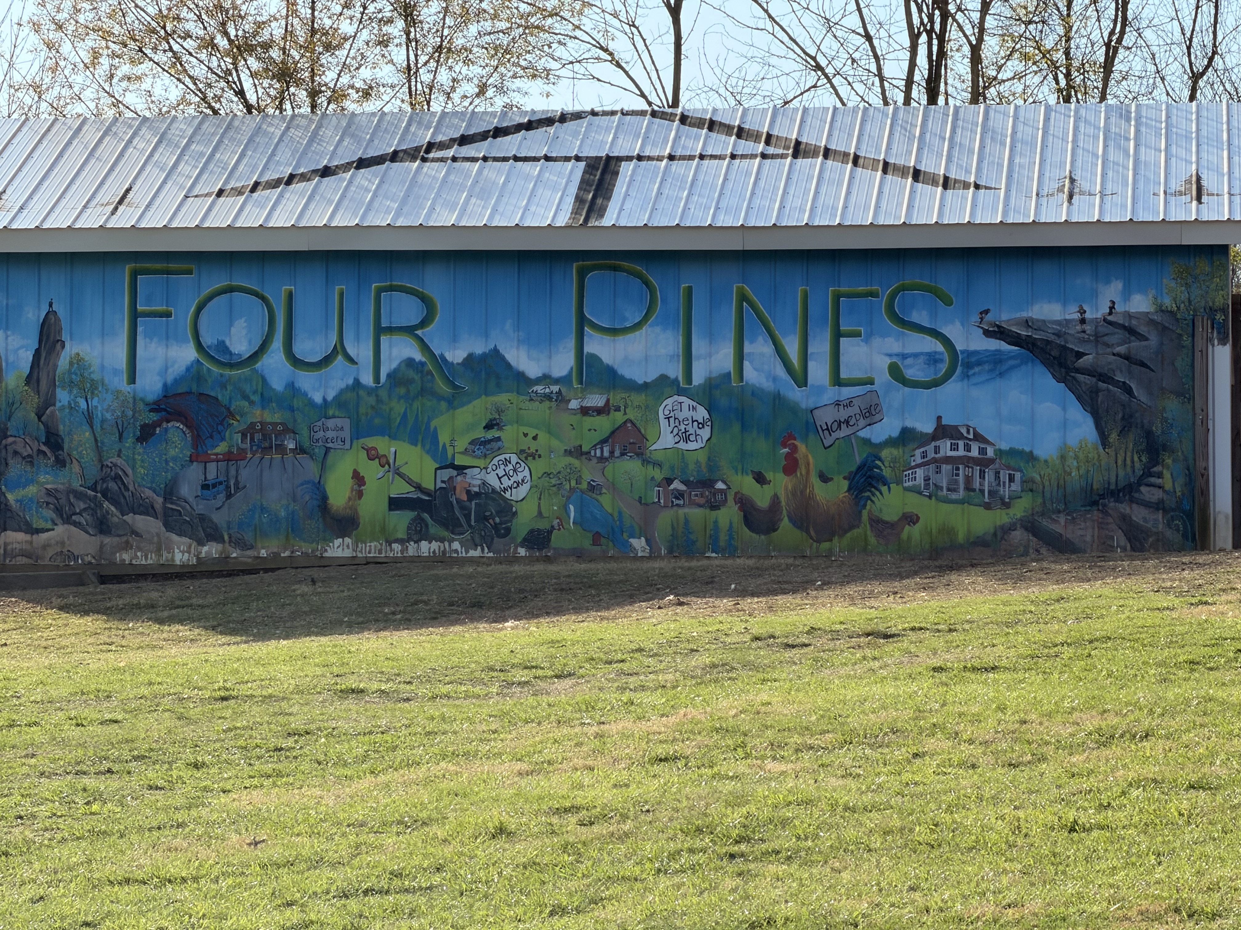
    Day 3 – Four Pines Hostel to Pickle Branch Shelter

    Tuesday March 31, 2026. Up at 7:30. Sunny going up to mid-70s.

    I slept very well. My heels are hurting this morning but the rest of me feels decent. Thought I would feel worse. Should be a good day!

    The hostel crew made us a nice breakfast. I decided that my pack was way too heavy due to excess food. I sorted my food bag and left a lot of food at the hostel. I left 2.5 lbs of food! That leaves me 3.5 in food bag plus 10oz Fritos, 1 M&M, 2 trail mix in hip pockets for 3 full days. The hostel’s scale says my pack is down to 30lbs, which sounds correct. 

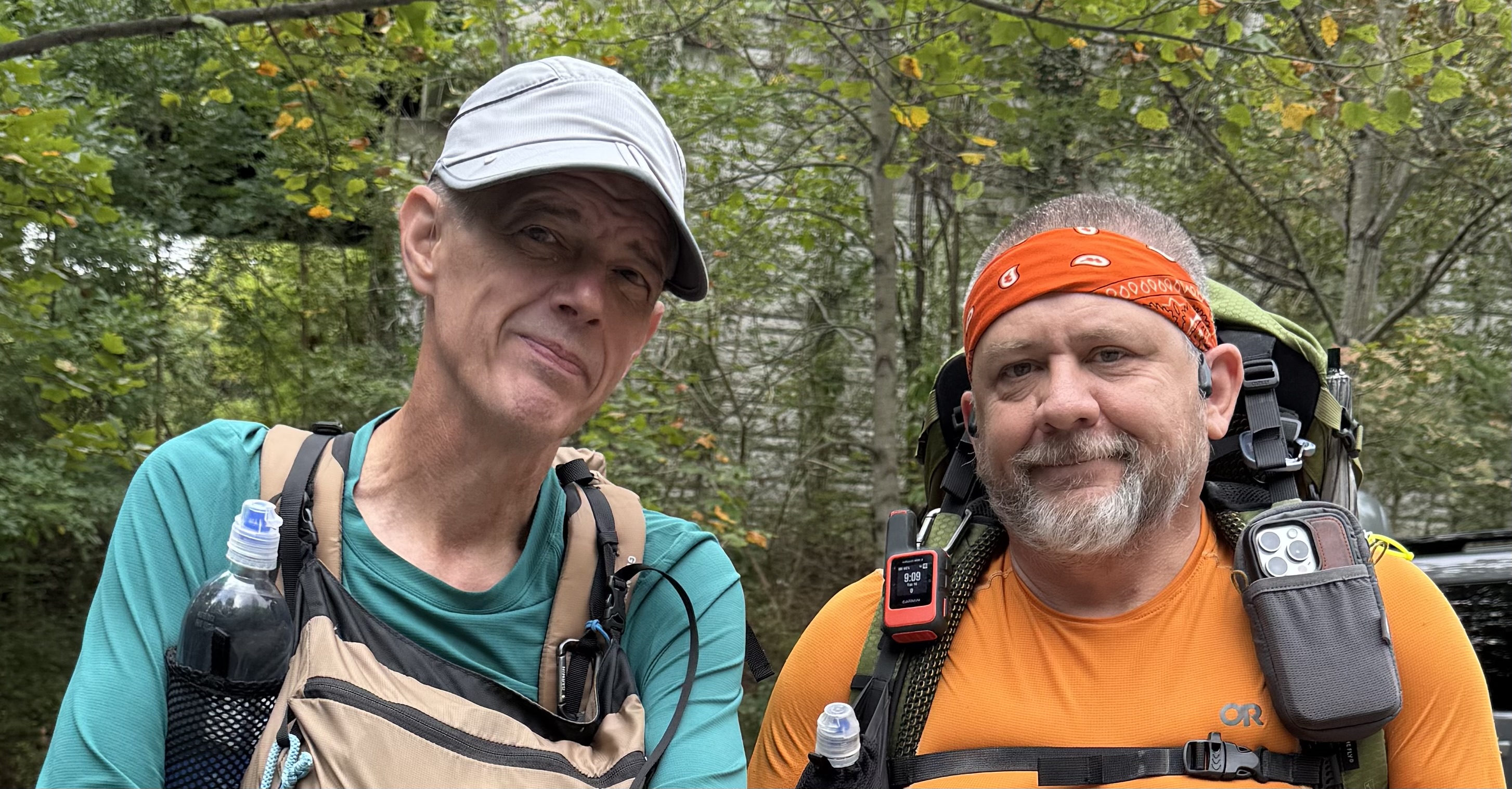
    We got packed up and walked the .5 miles back to the trail by 9:30. We are headed 2.7 miles up to Dragon’s Tooth. My recollection is that this is going to be a rough climb up steep rocky slabs. No water until about mile 9 today. 

    The ascent is about as I thought. Steep and rocky. We paused for a view back do to the hostel from last night at 10:05 and 1.44 miles.

    Chuck and Ed on ascent ot Dragon’s Tooth
    Looking down on Four Pines Hostel

    We had to walk around a 6 foot black snake who was winning himself on the trail. He refused to get out of our way.

    6 foot black snake on trail

    There is a spot on the ascent that we had to butt slide down last time I was here. It isn’t quite vertical, but darn close.

    Looking down a near vertical cimb on Drangon’s Tooth

    The last .2 3 miles are steep nearly vertical faces. You have to switch back up the rock face and be careful of your footing. Would not want to do this in the rain or ice.

    Ed standing on the side of the mountain near Dragon’s Tooth

    We arrived at the summit of Dragon’s Tooth at 11:25 and 2.95 miles. It is getting very hot and humid out here. I think I am going to have a bit of sun burn when this day is over. 

    Top of the ascent to Dragon’s Tooth

    The high school  group from the past two days got here before us. They camped at the end of the pastures yesterday instead at the base of Dragon’s Tooth as planned. They are finishing their hike in a few miles at the parking lot on the south side base of the Tooth.

    High school group at Dragon’s Tooth

    We took a 25 minute break on the top of the mountain before pressing on to Pickle Branch in 4.3 miles for water.

    Between the ascent up Dragon’s Tooth and the ups and downs over the next 5 miles, Ed was not doing too well. His legs just did not recover last night from our nearly 19 miles yesterday. Since we have to cross a gravel road near Pickle Branch, Ed decided to call the hike early. His brother Stuart will pick us up at the road around 3:00 this afternoon. 

    We met Stuart on trail about .5 miles before the road. He hiked towards us and brought us beer and soda. Thanks amigo! We hiked back to the car and Stuart drove me back to Blacksburg where I got my truck and drove back home to Maryland. I got home about 10:20 p.m. Nice evening for a drive. I also got to experience my first Buc-ee’s on the drive home up I-81.

    My first Buc-ee’S

    Overall this was a good hike for me. I got my new pack adjusted and felt very good the last 1.5 days on trail. No more back issues. I also realized that I just don’t eat much food on trail for the first few weeks. I had packed my food as if I had been on trail for several weeks, leading to a very heavy pack. That is probably the best lesson learned from this shakedown hike. I will plan much less food to start the PCT in a few weeks. I need to replace my hiking gloves. The right palm is tearing out. I also figured out a better way to arrange my gear in my pack. This new pack has two huge side pockets that are very deep. I found I can put my cooking pot and rain pants in one of the side pockets along with a 1 liter water bottle. That frees up some internal space. Nice!

    The biggest lesson learned, sorry Ed, is that we are not ready to do big miles yet. I remember that I intentionally did smaller 11-12 mile days for the first two weeks on the AT in 2024. And I took breaks every 2 hours and stretched my feet. Both of us need to keep that in mind. Me for my upcoming PCT hike and Ed’s AT LASH from Springer to Fontanna.

    Day 3 Map – Four Pines Hostel to Pickle Branch Shelter

    Technical Notes:

    • 2 eggs 160
    • 6 sausage patties 400
    • Biscuit 212
    • Coffee
    • Fatty Beef Stick 300
    • Water liter 3
    • Miles 8.73
    • Time 5:55
    • Up 2126
    • Down 2490
    • Calories consumed 1100
    • Calories burned 2711
    • Phone battery used 35%
  • Day 2 – Lambert’s Meadow to Four Pines Hostel

    Day 2 – Lambert’s Meadow to Four Pines Hostel

    Today’s Miles: 18.19

    Trip Miles: 27.79

    Day 2 – Lambert’s Meadow to Four Pines Hostel

    Monday, March 30, 2026. Up at  7:00. Cloudy and 45 degrees. Showers in the next few hours going up to 70.

    Slept decently for the first night on the trail. My back is very stiff but not nearly as bad as it could be. 

    Had breakfast, checked the weather, and got packed up fairly quickly this morning. We wanted to beat the rain that could start by 8:00. We started the 940-foot ascent to Tinker Cliffs at 8:00.

    The ascent up to Tinker’s Cliff was longer and harder than I remembered. The last time I was hiking, I was going down towards Daleville and not up this thing. We arrived at Tinker Cliffs at 9:10. It was breezy and looked like rain was moving in across the valley to the west. 

    Chuck at Tinker Cliffs

    It started to rain as we left Tinker Cliffs. Ed and I both used our umbrellas for most of the trek from Tinker to Campbell Shelter. The trail is not marked as well as it could be headed in this direction. We lost the trail several times. It was no big deal, but it was annoying. This rain makes all the leaves and rock climbs very slippery.

    Ed and his umbrella

    Finished the final steep climb to Campbell Shelter at 11:40 and had 6.1 miles. We got water, had lunch, put away our umbrellas, used the privy, and took a 30-minute break. There were several groups of people at the shelter getting water and avoiding the rain. They were all headed back the way we had come towards Daleville.

    Campbell Shelter

    We arrived at McAfee Knob at 1:15. That last .8 miles is very up. We have about 10 more miles to go today. This is going to be a long, hard day. Really feeling it in the hips and feet. Back is doing good though!

    View at McAfee Knob
    Chuck at McAfee Knob

    The rain stopped a while ago, and the sun is trying to come out. Warming up very fast, and it is very humid. We go to Rt 311 at 2:45. This is the new pedestrian bridge and parking lot for McAfee Knob. Took a 15-minute break, swapped water bottles, and rested my feet. We have 6.3 more miles to go. Lovely 🙁

    We crossed paths with the high school hiking group several times this afternoon. We took a break at 5:00 before crossing several miles of pastures. We have 2.7 more miles to go.

    Rest before crossing the pastures

    The last 3 miles were a death march. With a good-sized up and down in the last .7 miles. I struggled like I haven’t struggled in a very, very long time. My feet hurt like crazy. Hips are sore. Legs are dead. Absolutely exhausted!

    We got to the road for the hostel and did a .5 mile road walk to the hostel. Last thing my feet needed was the feel of hard asphalt under foot. 

    Four Pines Hostel

    Got to Four Pines Hostel at 6:45. We are the only 2 guests tonight. There are two guys here who basically are doing work-for-stay this year. Both past thru hikers. We got a basic dinner with our stay. Tasty and filling. Hot shower was nice. Basic AT bunk room hostel. Nothing fancy but does the job. Plus they had a soda machine!

    Four Pines Hostel

    In bed at 9:00. Today was a very hard day. It ended up being over 18 miles mostly uphill with a stupidly heavy pack. We should not have tried this many miles this early in the season. I don’t know about Ed, but my legs and feet are very angry with me. Curious to see how I feel in the morning. We decided to sleep in a bit tomorrow. 

    Day 2 Map – Lambert’s Meadow to Four Pines Hostel

    Technical Notes:

    • Pop tarts 360
    • Fatty beef stick 300
    • Double Stuff Oreos x 4 300
    • Peanut M&M 250
    • Biscuit 212
    • Rice and beans 500
    • Kielbasa 125
    • Soda 160
    • Soda 160
    • Water liters 4
    • Miles 18.19
    • Time 10:45
    • Up 4091
    • Down 4242
    • Calories consumed 2400
    • Calories burned 4712
    • Phone battery used 55%
  • Day 1 – Daleville, VA to Lambert’s Meadow 

    Day 1 – Daleville, VA to Lambert’s Meadow 

    Today’s Miles: 9.6

    Trip Miles: 9.6

    Sunday, March 29, 2026. Up at 8:00. Sunny and 34 going up to mid-50s. Sunrise: 7:08 a.m. Sunset: 7:41 p.m.

    Had a big breakfast in Blacksburg, VA with Ed and our friend Jon. Dropped my truck off at our friend Don’s house for the week and drove to Ed’s brother Stuart’s house to drop off Ed’s car. Stuart drove us to the trailhead. Thanks a lot, Don and Stuart. We really appreciate the support.

    We got on the trail where the AT crosses US 220 near Daleville, VA at 12:30. We are headed SOBO. I hiked this section in 2024 on the thru-hike NOBO.

    I’m carrying my full load for the PCT including 5.5 days of food and 1.75 liters of water. Call it 33 lbs. I won’t have to carry more than 3 days of food on the PCT until mile 300 or further. This is a good test / prep. There won’t be water until we reach camp in 9.6 miles today. If it were summer, like last time I did this, I would carry a third liter today. 

    Power line warning

    The first 2 miles were our worst climb of the day. Hiked up to a massive set of high-tension lines. You can hear them humming and crackling.

    We made it to an overlook of the Roanoke Reservoir at 1:45. That steep climb is as bad as I remembered it, plus I don’t have trail legs yet. 

    Ed at Roanoke reservoir overlook
    Chuck at Roanoke reservoir overlook

    I’m also still getting used to this new pack. I need to fine-tune it a lot over the next few days. Passed about a dozen day hikers in this area.

    We took a break to swap water bottles at 3:49 and 5.77 miles in. We have 3.8 miles to go until we reach camp. The pack is doing okay after some adjustment.

    We reached an overlook and cliffs at 4:30 and 7.1 miles in. My hips and calves are not happy. I have not carried more than 28 pounds yet this year and on less steep terrain. 

    View from ledges looking over Daleville
    Chuck at ledges looking over Daleville

    We got to the ledges at 5:00 with 1.4 miles to go. Took a short break. My back is not happy. More on that later.

    We arrived at Lambert’s Meadow campsite at 5:45. There is 1 bar of cell service. Great water right by my tent spot.

    Lambert’s meadow camp site

    We both set up our tents. I set up about 5 feet from a babbling stream just past that picnic table. While we were setting up, a group of 6 high school kids stopped for water. They are camping 2 miles further ahead. I guess they are out for the week based on their loads.

    We filtered water and made dinner fairly quickly as it’s getting cold fast. We had to put on my fleece while making dinner. We both finished dinner and got in our tents by 7:15. It’s going to be COLD tonight. 

    Decent day overall. My hips hurt a fair amount, but that’s expected with this much weight. My calves were a slight issue, which did surprise me. The real bummer is my back…again. The last 2.5 miles were very annoying. I will try shortening the torso length on the pack (thank god it’s adjustable) so that I can crank down my load lifters to raise the weight off my shoulders. The net effect SHOULD be to get more weight off my back and instead transfer it to my hips. I also need to rearrange the gear in my pack and try to get my camp shoes inside my pack so that they are not pulling down and back on the rear of my pack. I will work on all that in the morning.

    Tomorrow we have 17 miles and 2 big climbs in the first half of the day. There are only 2 options for water, and both are in the first 9 miles. This time of year, that should be fine in terms of water. Given my pace, which is very slow at present, and my back issue today, I guess we will need about 9-10 hours tomorrow.

    Curious to see how bad my back feels in the morning. It could be annoying, could be very painful. It also depends on how well my back feels after sleeping on an air mattress on the ground:)

    Talked to Dana for a few minutes and played some games on my phone until 10:30 before trying to get to sleep.

    Technical Notes:

    • 2 eggs: 140
    • 4 pieces of bacon: 210
    • 4 sausage patties: 250
    • Coffee: 90
    • Peanut M&Ms: 250
    • Dehydrated chicken: 170
    • Curry noodles: 450
    • Water liters: 1.5
    • Miles: 9.6
    • Time: 5:25
    • Up: 2352
    • Down: 1642
    • Calories consumed: 1600
    • Calories burned: 2969
    • iPhone battery used: 30%
  • Pre-Hike – Daleville, VA to Big Stoney Creek Rd, VA

    Pre-Hike – Daleville, VA to Big Stoney Creek Rd, VA

    Ed and I are slowly section hiking the entire AT. Since my AT thru-hike in 2024, I have a goal to section hike the entire trail again over the next few years between big thru-hikes.

    In addition, this hike will serve as a shakedown hike for my upcoming PCT thru-hike starting on April 24, 2026. The goals of a shakedown hike include:

    • test all my gear and clothes
    • make sure I did not forget to pack anything
    • double check how much for per day I need
    • fine-tune my new backpack
    • generally get my mind ready for another thru-hike

    I have been training for the PCT for the past several months. Day hiking with 20+ lbs and/or working out in the gym 4-5 days a week. We have had some wild winter weather for Maryland including the harshest winter in a long time. That has been great training for the PCT including the heavy snow with a thick layer of ice. The weather for this upcoming shakedown hike will be a good test with nights in the upper 30s and days in the mid-80s. Plus a little rain.

    I have my exact pack load that I will be carrying on the PCT including a 5.3 day food supply. That is the longest food carry that I will have on the PCT, so this is a great test.