We are hiking a short section of trail that I missed last year. This will 100% complete my journey of the Appalachian Trail. I tried to hike this once last October just after summiting Katahdin and again early this April before my 1 year anniversary of my start date, but the weather got in my way both times. Third time is a charm!
Up at 6:40. Quick breakfast at hotel then off to the trailhead. On trail at 8:00.
Reached the Connecticut border and water refill at 11:90 and 5.8 miles in.
Moving into ConnecticutWaterfall near the MA/CT border
Reached the state line at 12:46 and 6.73 in.
CT-MA state line
Bear mountain CT summit at 12:10. Looking back at Race Mountain.
Bear mountain CT summit looking back at Race Mountain
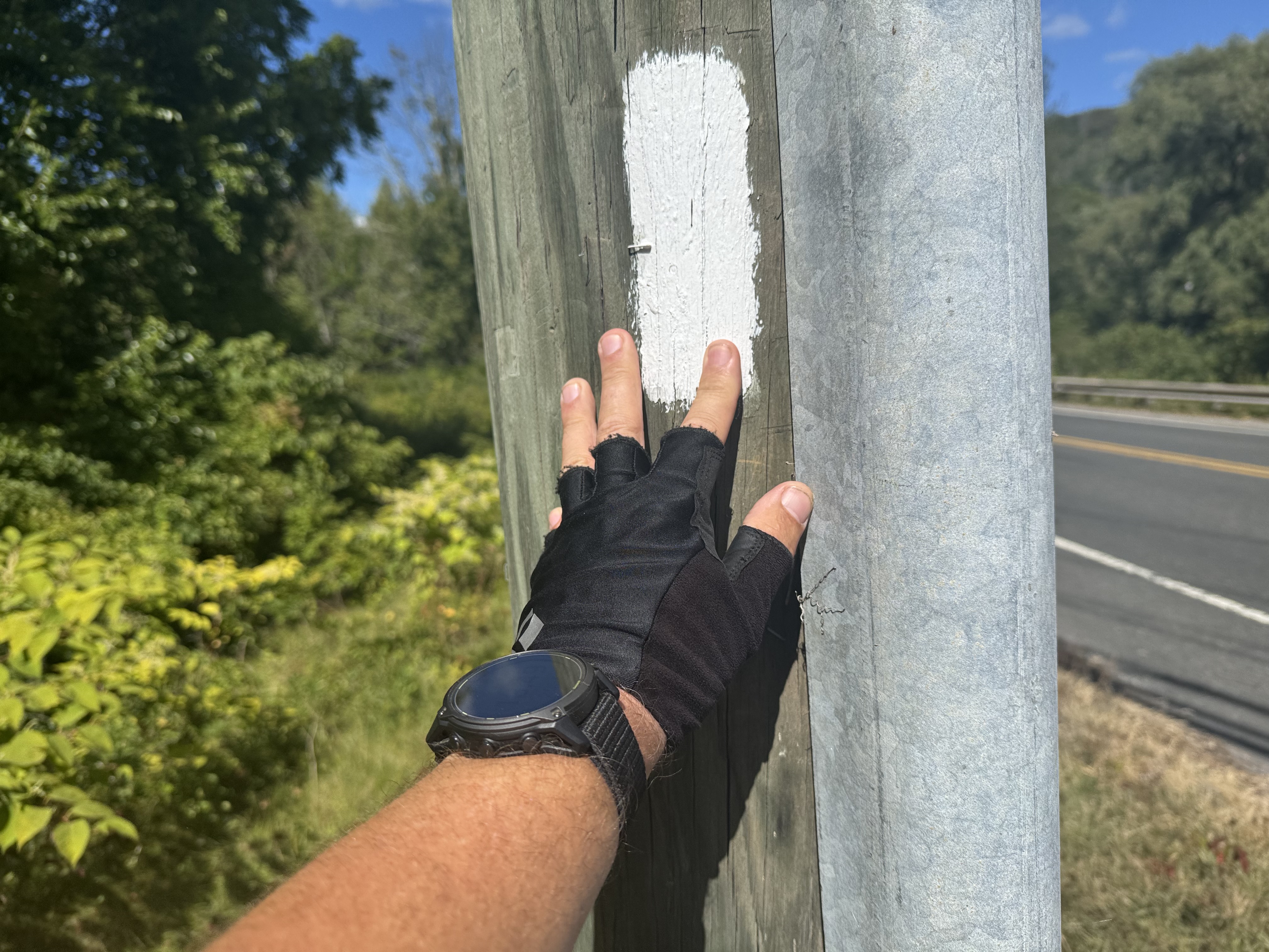
Finished at 2:50. This is a bit emotional as this is my final white blaze to 100% complete the Appalachian Trail.
My final Appalachian Trail Blaze
Got to White Hart Inn at 3:00. Jon Luning picked us up and drove us back to our car. We will be having dinner with Jon and Pam this evening in Pawling, NY.
Got up Sunday morning and drove back to Ed’s house in PA. Picked up my truck and drove back to Poolesville, MD.
Lost 7 lbs per the scale but I know I put on a lot of leg muscle. Overall, not bad weight loss.
And that’s it for this trip. Stay tuned for 3 more hikes before December this year.
Up at 7:30. Drizzle and chilly. Shuttled to trail at 8:30 by motel owner and on trail at 8:45. 14 miles to go today and weather is supposed to get better around 11:00 a.m.
Partly sunny, low 50s going to up to mid 50s. Scattered showers.
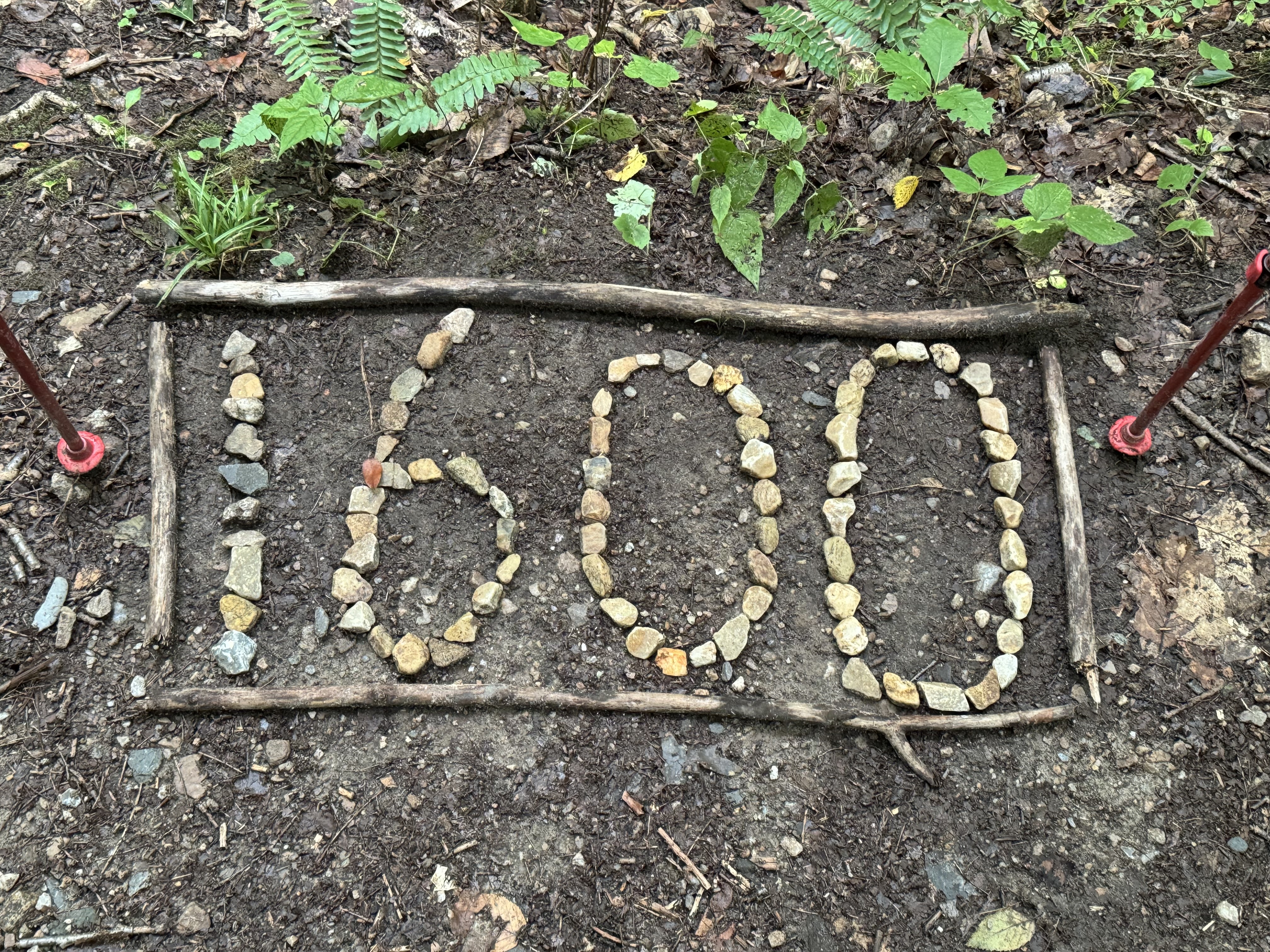
1600 Mile Marker
AT 10:00 I had a nasty rock scramble up into the clouds. Slippery rocks. Not fun.
Rock scramble in the rain
11:10 crossed into Vermont. Vermont being Vermud, that was as close as I could get to the sign without being ankle-deep in mud. I’m balancing on a half-submerged log.
Welcome to Vermont
This is what the trail was like all afternoon in Vermud.
VermudVermud
Stopped at Seth Warner Shelter at 2:30 and 9.3 miles in for a snack. Slow going this afternoon due to all the mud. Got 4.8 miles to my destination for the night. Should be there about 5:30. Met another Long Trail NOBO at the shelter. That makes two for today who are both headed to the same shelter as me for the night. Back on trail at 2:50.
The temps coupled with the wind and wet make for a very chilly afternoon. Low tonight is 45 with more rain. I feel like I’m back in the Smoky Mountains. Glad I got some of my cold weather gear back last week. Need to get the rest back soon. And it’s only August 20!
Got to Congdon Shelter at 5:15. Made really good time. There are 5 other people and a dog here tonight. Three are AT NOBO and two are hiking The Long Trail.
Ate dinner by 6:30, made my bear hang, and put on all my layers of clothes. It’s damp and going down to low 40s. I need to get the rest of my cold weather gear ASAP, including my 20-degree quilt. I’ll be climbing into bed by 8:00 just for warmth.
“Oh, keep your eyes on the road, your hands upon the wheel
Keep your eyes on the road, your hands upon the wheel
Yeah, we’re going to the Roadhouse
Gonna have a real
A good time” – The Doors
Up at 6:30. Ate breakfast and met my shuttle at 7:00. Drove to the trail and got hiking at 7:30.
Humid, mid-70s, rain and thunderstorms on and off all day. Very humid!
Confirmed my room and shuttle at Wicked Waystation for Thursday night. Looking forward to that.
I have Mount Greylock today. Highest point in MA at 3489 feet. Don’t expect much in the way of views with this weather. And it being a Monday, the lodge and restaurant at the top of the mountain are closed today. Go figure.
I have 3 potential camp spots tonight. First is a shelter. Second is a tent spot in a nice lady’s yard about 2.5 miles further. And third is a motel which requires a 3-mile road walk or hitch. The weather will likely be the deciding factor.
Cool walk up Greylock. The scenery and vegetation changed dramatically from the base to the top.
Just got a mini pecan pie and mini coke from a nice lady supporting a trail runner about half a mile from the summit of Mount Greylock. It’s these little things that really make a hiker’s day. Especially on a rainy, dreary day like today.
Eerie how that antenna mast just disappears into the clouds.
Antenna hidden in the clouds on Greylock
Made the summit at 11:15. Very foggy and no views today, but still pretty cool. Not a bad climb overall. The last .5 miles was the steepest with large, flat, slippery rocks. This heavy fog and earlier drizzle have everything wet and slippery.
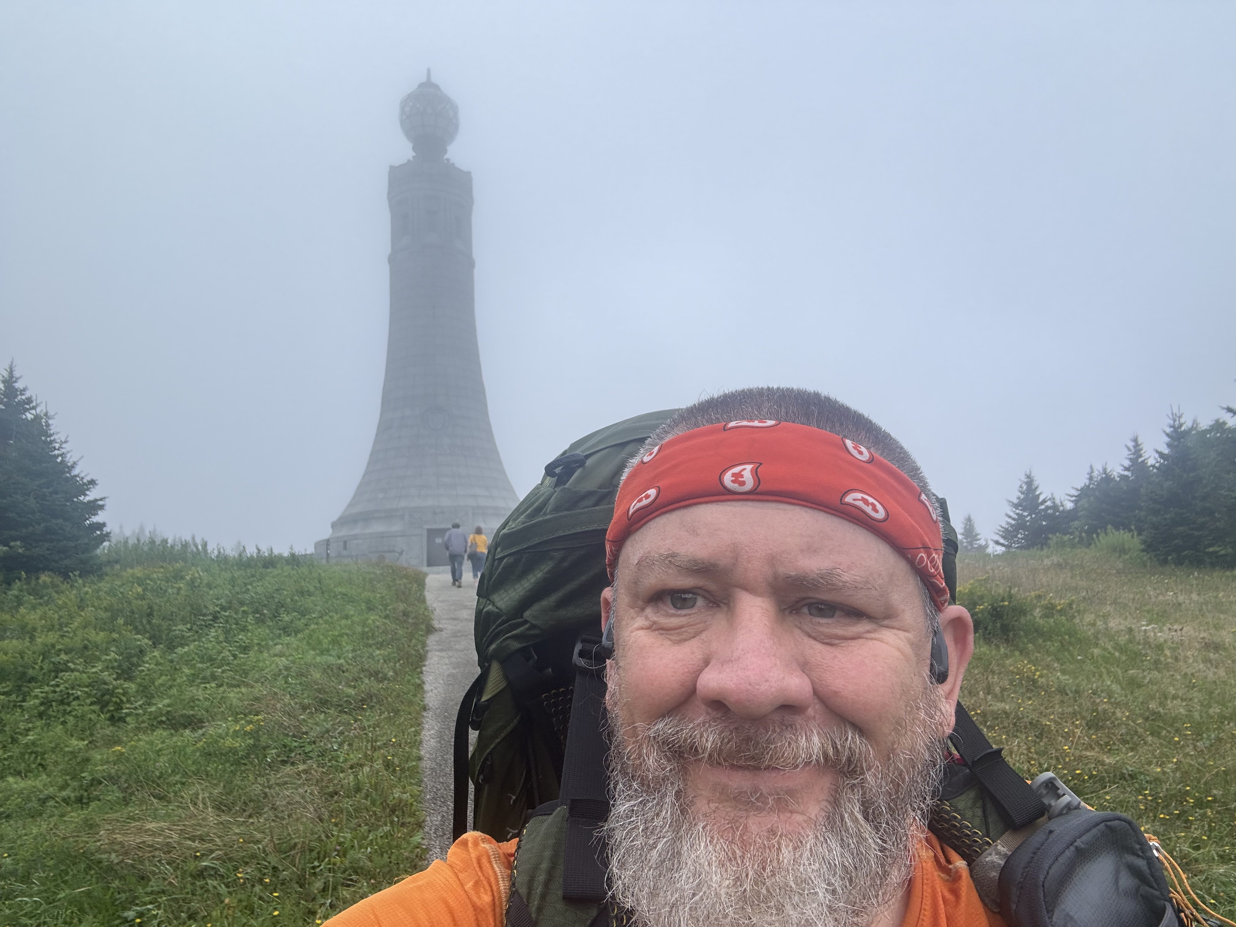
The tower is the Mount Greylock Veterans War Memorial Tower. If there was a view, I would climb the spiral staircase to the top of the tower, but I keep losing sight of the tower in the fog, and I’m only sitting about 25 yards from it!
Mount Greylock Veterans War Memorial Tower
And as I was getting ready to leave, it sort of cleared up. I did climb the spiral stairs to the top and got a little view.
Looking down the spiral stairs in Mount Greylock tower
Stopped at a road crossing with a nice sitting rock for a snack at 2:00. The sun is trying hard to come out, but there is rain in the forecast around 5:00. I should be under cover by then.
Heard from Legend. He’s half a day behind me along with this crew. I thought they were a couple of days ahead of me, not behind me. They will catch me in 1-2 days at their pace.
Legend and the Rascals
View from the top of Mount Prospect. That’s the border with NY in the middle distance looking west.
View from the top of Mount Prospect
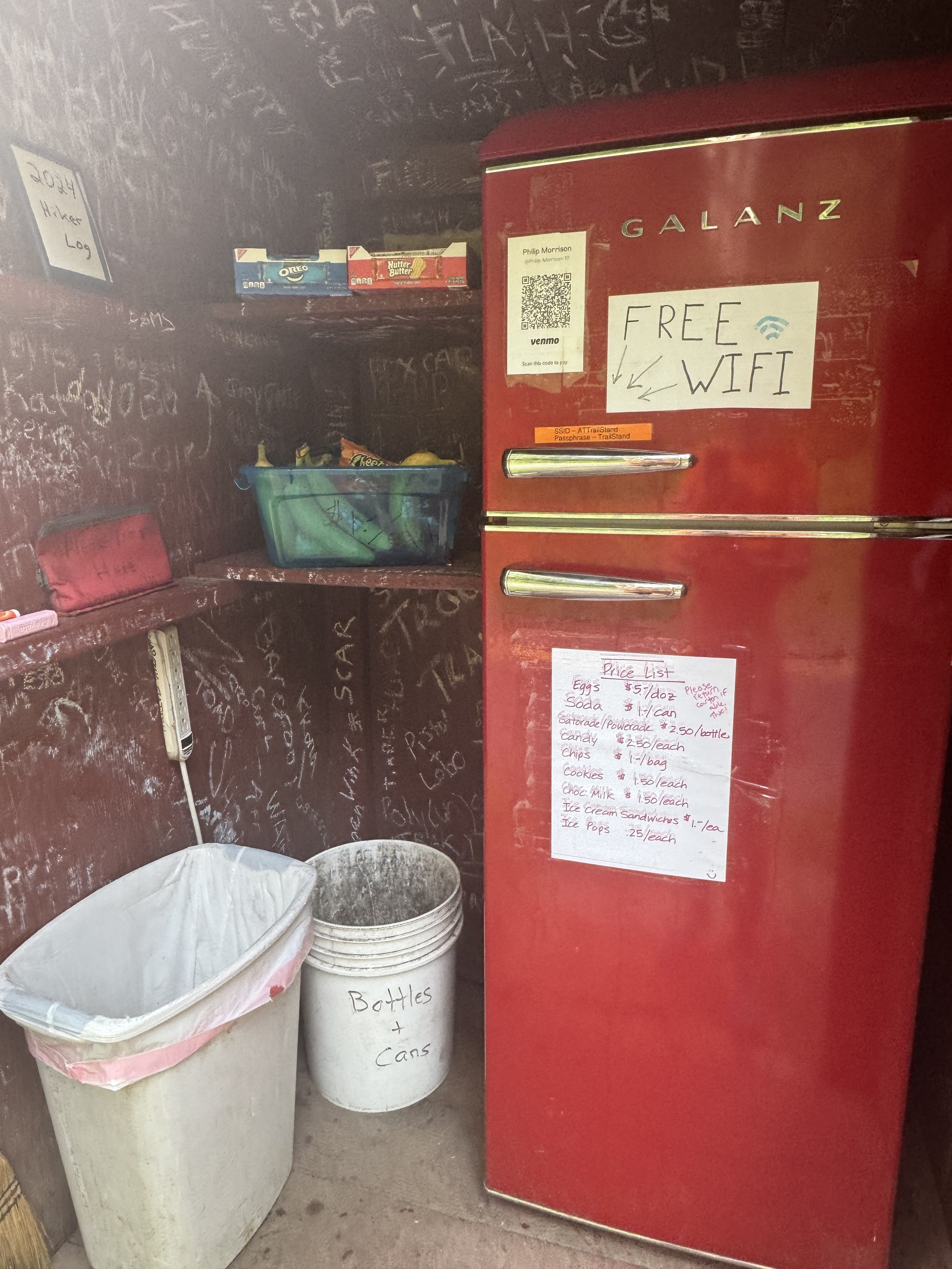
Got to town at 4:00. The trail runs down one of the streets in town. Walked to the AT welcome kiosk with self-service trail magic in coolers next to the local elementary school.
Called The Willows Motel for a pickup. Very cool that they offer rides to/from the trail. I got picked up just as the thunderstorm hit. I watched it roll in over the backside of Mount Greylock. The mountain just slowly disappeared into the rain and clouds. This is a cute little family-run motel. It’s got that 1950s vibe and is very well maintained. Very friendly Indian family runs the place.
The Willows Motel in Williamstown
Walked next door to an Italian place for pizza. Almost ordered real food, but I had been thinking about pizza since I got to town. Very good pizza!
Back to the motel around 7:15 and chatted with Dana. Probably be asleep by 9:00.
Woke up to heavy rain and no motivation. Studied the weather forecast and the trail for the next two days and decided to take today off.
Walked across the street to a diner for breakfast and ran into 4 young hikers I have been seeing on and off for a week.
Spent the day REALLY replanning the rest of my hike. I am lowering my mileage to about 14-15 max per day and revisiting hostels and other plans in the Whites and in Maine. Trying to be more realistic and cognizant of earlier sunset and my general lack of motivation lately.
I am fairly happy with the results. I should finish on Oct 7 in a perfect world. But with weather issues in the White Mountains, I foresee the schedule moving out to October 13 weekend.
Arranged shuttle for 7:30 a.m. tomorrow and booked a bunk bed for Thursday night at Wicked Wayside.
Walked to Walgreens and picked up a few supplies for the next 4 days. Had the second half of my sub from yesterday for dinner.
I’m reasonably happy with my new route plan. I think/hope the shorter days will keep me more energized and focused. Should know how well that is working by next weekend.
All packed up and ready to go in the morning. Still carrying too much food 🙁
Stopped at The Cookie Lady at 9:45. Awesome place. Got a big homemade berry juice , cookies, and good water! Did not need to charge anything. Played with the dogs.
The Cookie LadyThe Cookie Lady
Back on trail at 10:15. I have 9.6 miles to Dalton, MA.
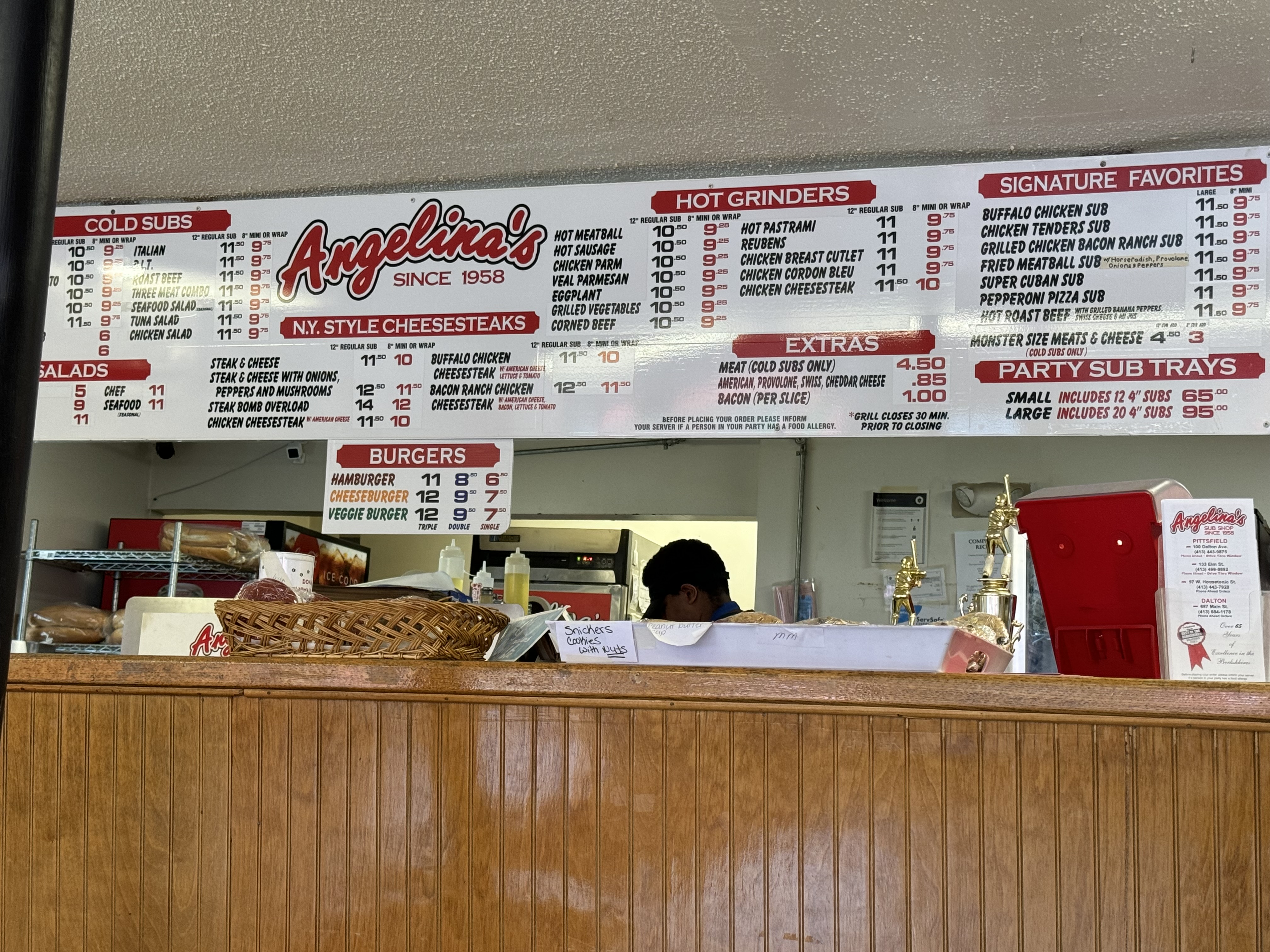
Got a room in Pittsfield, MA, and a shuttle from Dalton. Got to Dalton at 3:30. Stopped at an awesome sub place to get dinner to go, then shuttled to the motel.
Sub shop in Dalton, MA.
Worked on blogs, called Dana, worked on planning for the next few weeks.
Head is still not in the right place. Part of it is the weather. Sunday looks rainy but doable. Monday looks terrible. I have Mount Greylock either tomorrow or Monday. Lovely. No good choices.
Day 126 Map – October Mountain Shelter to Dalton, MA
Stockbridge, Massachusetts, where this happened. They got three stop signs, two police officers, and one police car, but when we got to the
scene of the crime, there were five police officers and three police cars,
being the biggest crime of the last fifty years, everybody wanted to
get in the newspaper story about it. And they were using up all kinds of
cop equipment that they had hanging around the police officer’s station.” – Alice’s Restaurant
Up at 7:00. Ate and packed up and attached my new phone pouch to my chest strap. Headed out at 7:50. Stopped at Dunkin on the way out of town.
Upper 70s, partly sunny, not bad humidity, chance of afternoon thunderstorms.
Hitched a ride the last 2 miles with a local handyman. Rode on the back of his flatbed. Perfect morning. On trail at 8:30.
Ran across these free walking sticks. Very cool.
Free walking sticks
Hiked near Stockbridge, MA today.
Good hard climb this morning. Good to get my legs used to this again as the Whites are looming. Also carrying too much food, but I’ll eat through that over the next 3 days.
Took a break at mile 3. Great sitting rock in the shade and decent cell service. Got a tough 1.4-mile climb right after this.
Stopped at MA Route 23 parking lot for a water cache and trail magic at 1:30 and 8.4 miles so far today. Cokes, peanut butter cups, Gatorade, oranges, apples. Thanks much!!
MA Route 23 parking lot water cache and trail magic
Still have 9.2 miles to go. Hoping for 6:00 but probably gonna be more like 6:30.
Yet another big pond or small lake. Lots of these the past few days.
Lots of ponds and lakes in MA
Quick break at 3:45. Tough climbs this day!
Swapped water bottles and had a snack at 5:15. Got 3.5 miles to camp.
Got 3 liters of water for tonight .3 miles before camp. Very cold water!
Not your average water spot
Set up camp at Shaker Campsite at 7:15. Privy, bear box, tent pads. Nice!
Shaker Campsite
Long hard day. One of the biggest vertical days in a while. Felt good physically and mentally. Now let’s see if I can string two days like this together.
Day 124 Map – Great Barrington, MA to Shaker Campsite
“We were holding hands as we reached the California coast.
A new wind in our sails, we’re making the most.
So the story goes, all’s well that ends well.
And if you don’t mind, I’ll keep the rest to myself.
I was thumbing my way outta San Antonio.” – Tracy Byrd
Up at 6:30. Dense fog, so I went back to sleep until 8:00. Packed up and hit the road at 9:00.
Very hazy and humid today. View from Mount Prospect.
View from Mount ProspectView from Mount Prospect
Stopped at Giants Thumb. Great big thumb-shaped rock.
Giants Thumb.
After a lot of debate, I decided to only hike to Salisbury, CT at mile 8 for today. I have to be at the post office in Great Barrington before they close. Once I head out of Salisbury, there is no road near the trail until mile 19.6, which won’t let me make the post office. I had thought about going another 7 miles on the AT and then hiking what looks like an abandoned woods road out to Route 41 for a shuttle pickup. However, that would put me real close to missing the post office, and there is no info on what shape that “woods road” is actually in or if it still exists.:(
I’m skipping ahead 20 miles to Great Barrington, MA. The town is 3 miles north of the AT. I’ll hitch back to the trail tomorrow or something similar. I need to make up time/mileage, and this looks like a reasonable opportunity for that. I plan to come back here the last week in October with Dana and day hike this missed stretch of trail. It’ll be under 10 hours with a day pack.
Stopped at the White Hart Inn, Salisbury, CT. Very nice little place. I plan to stay here with Dana in late October when I make up a missed section on the AT.
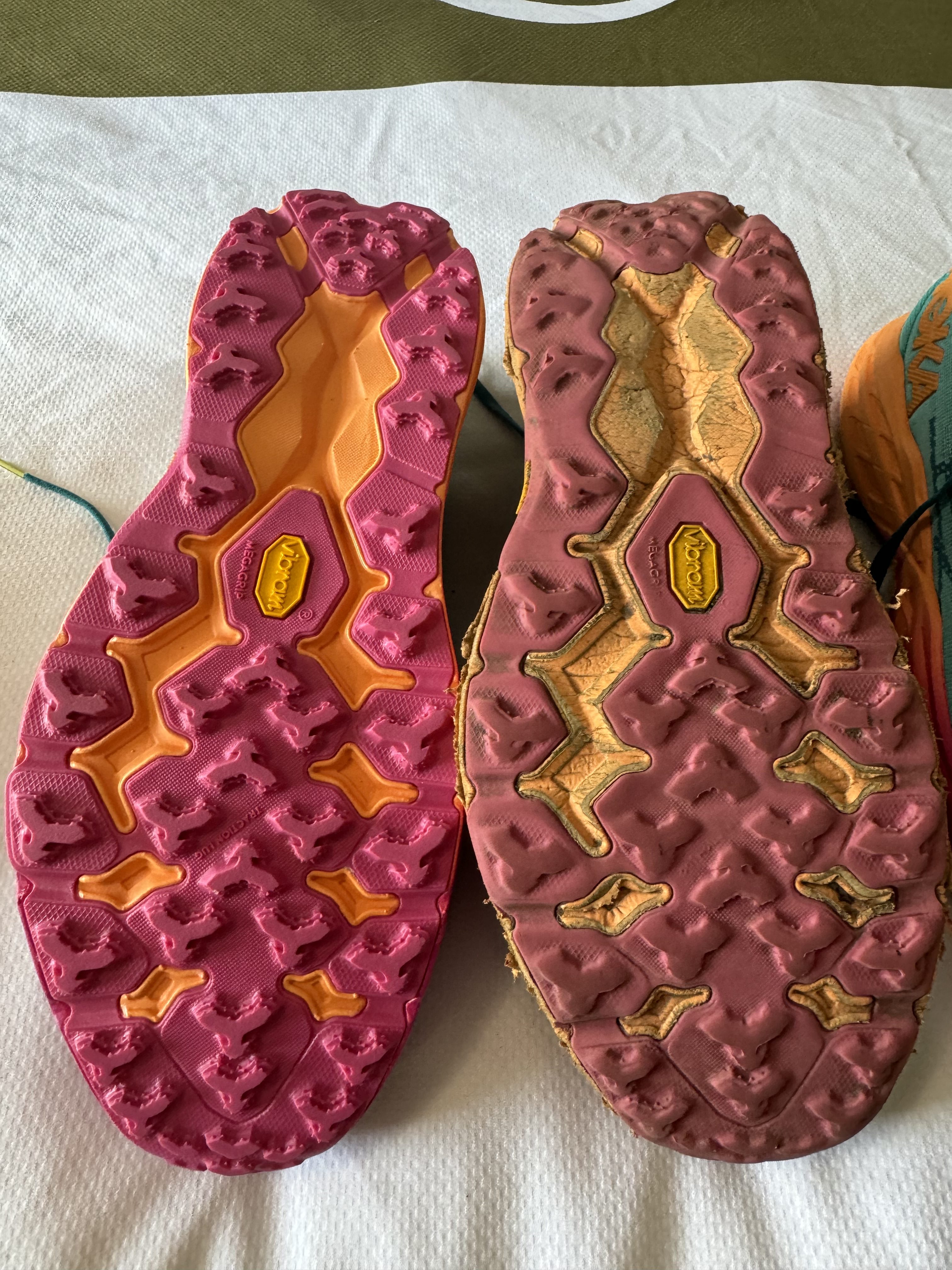
Got picked up by a shuttle at 2:00 and drove to the Great Barrington, MA post office, then to the Quality Inn. Got new shoes and a new phone pouch as well as my rain jacket and hiking pants and extra socks back. Also, a few resupply items. I’m pretty good on supplies as is.
New shoes in Great Barrington, MA
Showered and did laundry. Did major route planning for the next 11 days. Trying to get back into bigger but reasonable days. I’m trying to get my head back in the game! I need to really dig in if I’m going to finish this adventure before the snow closes the northern terminus.
I just have not been loving life on the trail since NJ. Go figure NJ and NY weren’t my favorites. Too many people, too many towns, too many distractions. That’s my guess anyway. I’m hoping getting back into the sticks and into New England will help. My new route plan tries to balance aggressive miles with a dose of reality. Plus new shoes will really help 🙂
Day 123 Map – Great Falls, CT to Great Barrington, MA