Tag: Pre-Hike

  • Travel Day – Maryland to San Diego

    Travel Day – Maryland to San Diego

    Pit Crew drove me to Dulles Airport to catch a morning flight to San Diego via Denver. Said goodbye to our dog, Pendleton. That’s always hard since he has no idea what I’m saying and probably will think I’m never coming back.

    Pendleton

    Hugged Pit Crew goodbye at the airport. We won’t see each other until I get to Lake Tahoe around July 10…over 2.5 months away if all goes well. Saying goodbye is hard, but not as hard as leaving her standing at the trailhead on the AT waving goodbye and knowing all I have to do is turn around and walk back to her. We just got back from a very nice vacation in the Florida Keys, so we both have those recent memories to hang onto. That trip was my partial repayment for leaving her alone to manage everything for almost half a year.

    Pit Crew and Orange Man pre-hike

    Checked my duffel bag containing my backpack and got through airport security in just a few minutes. Pulled out fuel can, lighters, water filter, meds, electronics, and my fleece. All but fuel can are in my small carry-on. Very quiet at the airport this morning. I’ll ship that duffel and carry-on home from San Diego tomorrow.

    Duffel bag containing backpack for PCT
    Quiet morning at Dulles Airport

    Had an uneventful stay in Old Town San Diego. Repacked my backpack and finalized plans for tomorrow. I have to ship my duffel bag home, get a shuttle from San Diego to the Camp Lockett Event & Equestrian and Facility (CLEEF) campground, pick up a fuel canister, and get my head ready for almost 6 months of hiking.

  • Logistics, Overview, and Schedule on the PCT

    Logistics, Overview, and Schedule on the PCT

    This article originally appeared on The Trek, which you can read HERE.

    The Permitting Process

    Unlike the Appalachian Trail and many other trails on the East Coast, the PCT requires a permit to hike the trail. Those permits are not easy to get for a desired start date. The PCT Association uses a random lottery system to assign permits. You can only apply for one permit once per hiking season. 

    The way the process works is that you randomly get assigned a time to log into the permit portal on Permit Release Day (November 13, 2025 for the 2026 hiking season). There are 35 permits available per day from March 1 through May 31. The permits for a given date are assigned on a first-come, first-served basis. That means the earlier in the day you get assigned a time slot to log in, the better your chance of getting a good start day. Later in the day (typically by 1:30-2:00), all the permits are taken for all the dates. Hence why not everybody who wants a permit gets one. It is a lottery!

    I was happy with my draw in the lottery. I received a 12:20 application time, which put me a little before the halfway point, which should mean that there are a few dates in April still available. When I got into the portal, at 12:20:40, all the permits through April 23 were taken and there were only 7 permits left for April 24. I grabbed an April 24 permit quickly!

    PCT Overview

    The first 700 miles of the PCT are in the Southern California desert. That section is typically very dry, and water can be an issue. There are parts of that section where I will have to carry 5 liters of water (11 pounds) and be careful with that supply of water. Much of the time, there is little to no shade, and it can be very windy. Daytime highs should be anywhere between 65 and 90 with lows between 32 and 45. There are quite a few small towns, hostels, or volunteer-provided waysides in this section. The average number of days to hike that section is 48 days. 

    The second major section of the PCT is roughly 400 miles through the High Sierras. This includes very remote areas, long 5-6 day food carries, traversing alpine snow fields, snow-covered mountain passes, lots of water crossings from snow melt, elevations up to 14,500 feet, and some amazing scenery. I will cross through Sequoia, Kings Canyon, and Yosemite National Parks and traverse the John Muir Wilderness and the Ansel Adams Wilderness, eventually finishing in the high desert just before South Lake Tahoe. The average duration for the High Sierras is 38 days.

    The third major section is 600 miles in Northern California ending at the Oregon border. Water should not be as problematic as in the desert, but with this being a drought year, it may get a little problematic. There are quite a few small towns along the way for resupply, and I only anticipate one 5-day food carry in this section. There are lots of long steep ascents/descents in this section, particularly into and out of towns where roads cross the trail at the bottom of a valley. The weather will be hot and, hopefully, dry. This is where wildfires become not just a possibility but a fact of life. The average duration for the Nor Cal section is 30 days.

    The fourth major section is approximately 450 miles across the state of Oregon. This section is “flatter” than Nor Cal, but with lots of mosquito activity in the summer. This section includes Crater Lake, the Three Sisters Wilderness, and Mount Hood. This is also an area that has frequent wildfires during the summer and fall. The average duration for the Oregon section is 23 days.

    The fifth major section is approximately 600 miles across Washington state in the North Cascade mountain range, ending at the Canadian border. Much of this section is remote and rugged, with constant ascents and descents. Given how late in April I am starting, completing Washington and reaching the Canadian border before the high mountain passes are closed for the season due to snow may be a challenge. The average duration for the Washington section is 27 days. That includes the two-day hike BACK from the Canadian border to reach civilization and leave the PCT. 

    Resupply on the PCT

    My plan for resupply on the PCT is a bit different than my original plan for the AT. I only plan to mail myself supplies when 1) I need to change gear (just before and just after the High Sierras), 2) to restock up on prescription, 3) there is no other good choice for getting food. I am keeping resupply boxes to a minimum with only 11 planned, and I hope to skip a few of those. The rest of the time, I will resupply from confidence stores, outfitters, or equivalent when I can get to town. Note that getting to town will involve a LOT more hitchhiking on the PCT than I did on the AT. 

    Pit Crew will mail my resupply boxes a few weeks before I need them. That way, she can add things that I can’t plan out ahead of time, like new shoes, a new pair of hiking pants after I lose a ton of weight, etc.

    PCT Resupply Box

    Gear for the PCT

    My gear, including clothes, mainly consists of items that I used on the AT in 2024 and numerous section hikes since then. The exceptions to that are a new backpack, a new fleece, micro-spikes, ice axe, bear can, and an Ursack. Other than these exceptions, I am just going to refer to my detailed PCT gear page on my personal website instead of regurgitating all the gear info here. 

    PCT Gear

    The new backpack is the lighter version of the Osprey Atmos AG 65 pack that I used for the second half of the AT. This new version has the EXACT same beefy suspension system, but ditches a bunch of internal compartments, zippers, and other bells and whistles in order to shed about 1.5 lbs of weight. Also, I have removed the lid/brain from that pack for weight savings. Even with that weight savings, it is a heavy pack at 3.53 lbs, but I know that it does not cause me back issues. I will take that trade-off. 

    For the desert section of the PCT, there are no requirements on how you store your food. However, there are strict regulations in the Sierras and the first part of Northern California that require a bear-resistant hard-sided container called a Bear Can. My Bear Can weighs 2.5 lbs empty and takes up a lot of space. I am not looking forward to carrying that thing for almost 500 miles, but the fines are nasty, and I could get my permit revoked if I am caught without it. Once I get north of the Desolation Wilderness in Northern California, the hard-sided container rules go away, but there are still requirements in various areas for bear-resistant food storage. When I send the bear can home, I will switch to an Ursack. The Ursack is a lighter weight (13 ounces) soft-sided food storage container that meets the new food storage regulations in Northern California, Washington, and Oregon.

    Bear Can and Ice Axe

    For Mount Baden-Powell and the High Sierras, I will be using Micro-Spikes. These are steel spikes that get attached to the bottom of my shoes to prevent slipping on ice and snow. For the Sierras, I will be carrying an Ice Axe. The purpose of the ice axe is to help arrest a fall and slide down an icy/snowy slope. I will send the spikes and axe home from Lake Tahoe.

    Overall Schedule on the PCT

    This will be a very interesting year to hike the PCT. There has been very little snow in the Sierras and Cascades this year. Lots of rain, but warm temperatures have kept the snow to a minimum except at higher altitudes. Some areas are reporting only 20-30% of the typical snowpack for the year. That is a double-edged sword. That SHOULD mean less snow at lower elevations to have to deal with. There will always be snow at higher elevations to deal with. The lower snowpack COULD also mean that the water crossings due to snowmelt in the High Sierras will not be as deep or swift this year. Only time will tell on that item. However, the lower snowpack also means less drinking water and a higher risk of wildfires in the summer and fall.

    I am starting on April 24, 2026. I feel confident about making it through the desert and making it to the start of the Sierras at Kennedy Meadows South by June 9. There are two mountains that I need to cross in the desert section that usually have snow this time of year. The first is Mount San Jacinto. As of mid-April 2026, there is no snow on that peak, so I don’t have to worry about having my micro-spikes or ice axe for that. The second is Mount Baden-Powell. That mountain still has snow and difficult terrain, so I will need my micro-spikes but not my ice axe based on recent hiking reports from that area.

    Once I reach the start of the High Sierras around June 9, things start to get tricky. It is not safe/advised to start into the High Sierras until the snow has sufficiently melted. This is USUALLY around June 15. This year, with the lack of significant snow, I should be able to start into the Sierras immediately. I will not know for certain until sometime in May when the early-season hikers send back information on trail conditions. That said, they received five feet of snow over the course of two snowstorms in early April in the Sierras. 

    I hope to complete the Sierras and reach South Lake Tahoe around July 7. Pit Crew will fly out and meet me in Tahoe for a well-deserved double-zero day off-trail. 

    Without getting into too much detail, my goal is to reach the Canadian border by September 30. That is a bit aggressive, but I am worried about early-season snow in the Northern Cascades, which could bring my adventure to an abrupt and early halt. Only time will tell if I can get to Canada before the first snow!

    Happy Trails

    That’s all for now. Before I get on trail in the very near future, I plan to do a post with Frequently Asked Questions. I will be posting trail-log summaries on The Trek and posting daily detailed trail logs on my Web Site. Until then, keep on keeping on! 

  • I am never doing another long-distance hike!

    I am never doing another long-distance hike!

    This article originally appeared on The Trek, which you can read HERE.

    I told myself and my girlfriend that I was never doing another long distance hike. Or so I thought after finishing my Appalachian Trail thru-hike in 2024. Little did I realize just how addictive long-distance hiking was and how much post-trail depression would impact me.

    What is post-trail depression? In general, “a common, often intense, period of sadness, anxiety, and loss of purpose experienced by hikers after finishing a long-distance, life-changing journey.” I heard about post-trail depression prior to my AT thru-hike, but I never gave it much thought. Sure enough, I started to feel its impacts the day I summited Katahdin. Those feelings got more intense in the months after. I knew the only way to fix this was to get back on the trail. I summited Katahdin on October 6, and I think I decided to do another thru-hike by early December of the same year. 

    Why another thru-hike?

    I am fortunate to have retired early, and my body is in fairly decent condition. The reason I retired early sucks (I miss you, Andrea), but life must go on. Read my bio for more. The fact that my body can handle long-distance hiking is a bit surprising given how much abuse my body received in my 20s, 30s, and early 40s. I have become a bit of an exercise addict in retirement. I realized that the best way to stay healthy, feel good, and have a long life is to stay highly active. What better way to stay active and exercise than to lug around a 27-pound backpack for hundreds or thousands of miles at a time? A body at rest tends to stay at rest, and a body in motion tends to stay in motion.

    I have an amazing support system at home in the form of my girlfriend Dana, a.k.a. Pit Crew. Pit Crew is not retired and will be working full time for several more years. She understands why I hike and encourages me to do so. She not only encourages me, but she supports me on trail whenever possible. This includes taking care of the house and the dogs when I am away, sending me resupply as needed on trail, texting with me to keep my spirits up, and making visits to me on trail. Even if those visits are half a day away from home or, in the case of the PCT, over 3000 miles away. She is always there to support me. Hence her trail name Pit Crew. 

    I look at hiking as my retirement gig. Be it day hikes, 5-day section hikes, 2-4 week LASHes, or thru-hikes. Pit Crew calls it my post-retirement job. When I grab my day pack and head out for a 12-mile hike, she tells me “have a good day at work”.

    All that said, Pit Crew and I have an understanding. I will alternate big thru-hikes (i.e. AT, PCT, CDT) every other year and do smaller thru-hikes (i.e. CT, AZT, Long Trail) and LASHes in the off years. The plan is to get the 4-6 month monster hikes done before she retires.

    Planning for the AT vs. Planning for the PCT

    There are a lot of differences between the AT and the PCT. Weather, terrain, altitude, water, remoteness, and more. More on how those impact planning and logistics in another post. What I found to be the most interesting difference about planning for my first thru-hike on the AT versus my second thru-hike on the PCT was the lack of urgency and the general “it will be what it will be” attitude that I had. 

    For the AT, I planned things out in excruciating detail. Where I planned to stop every night, exact mileage, 20+ resupply boxes, etc. There was also the constant feeling of anxiousness leading up to the start of the hike for many months. 

    For the PCT, things have been just a bit different. I have had to plan out my mileage in general mainly because I have to ship gear for the High Sierras to and from trail and, being an old fart, I have to ship meds to trail every 20-30 days. But I don’t feel the sense of urgency or anxiety that I did for the AT. Even though I have never hiked in the desert before nor traversed snow-covered mountain passes at 12,000 to 14,000 feet of elevation before. I am doing minimal resupply boxes on the PCT and I have found myself letting all my resupply box preparations linger until literally the last 1-2 weeks before leaving for California. I am not worried about if I will find a place to stay in town or how I will get to/from trail and towns. It will be what it will be. 

    I was discussing this with a hiking friend who has kids, and it is reminiscent of the first kid versus the third kid. For the first kid, you overplan everything, obsess about healthy meals, arrange playdates, and generally hover over the child. For the third child, you are feeding them Cheetos to keep them quiet, telling them to “get out of the house and find something to do”, and thinking “no blood, no foul” or “for gods sake, just walk it off”.

    Happy Trails

    That’s all for now. Before I get on trail in the very near future, I plan to do a post about PCT planning and logistics and one that deals with Frequently Asked Questions. I will be posting trail-log summaries on The Trek and posting daily detailed trail logs on my blog at https://retiredhiker.com/pacific-crest-trail/ . Until then, keep on keeping on! 

  • Gear List for 2026 PCT Thru-Hike

    Gear List for 2026 PCT Thru-Hike

    I plan to start my PCT thru-hike on April 24, 2026, without my Sierra Mountains gear. Since it is a very low snow year, I do not need Micro-Spikes or an Ice Axe for Mount San Jacinto. I will ship my Micro-Spikes to Wrightwood, CA, as I expect to need them to summit Mount Baden-Powell. That adds 13 ounces to my gear. I will ship the Micro-Spikes home once I got to the next town, as I will not need them again until I reach the Sierras.

    For the desert section of the PCT, there are no requirements on how you store your food. However, there are strict regulations in the Sierras and the first part of Northern California that require a bear resistant hard sided container called a Bear Can. My Bear can weighs 2.5 lbs empty and takes up a lot of space. I am not looking forward to carrying that thing for almost 500 miles, but the fines are nasty and I could get my permit revoked if I am caught without it. Once I get north of the Desolation Wilderness in Northern California, the hard-sided container rules go away, but there are still requirements in various areas for bear resistant food storage. When I send the bear can home I will switch to an Ursack. The Ursack is a lighter weight (13 ounces) soft sided food storage container that meets the new food storage regulations in Northern California, Washington, and Oregon.

    I will ship my Sierra gear, including my Bear Can, Ice Axe, and Micro-Spikes, to Kennedy Meadows South. I will send the Ice Axe and Micro-Spikes home from Lake Tahoe. Unfortunately, the new regulations make me keep my Bear Can until I get through the Desolation Wilderness north of Lake Tahoe. I will ship the Bear Can home from Sierra City, CA, and exchange it for an Ursack.

    My starting base weight is 19.45 lbs, and my total weight with 2.6 days of food and 2 liters of water is 27.77 lbs.

    My starting base weight for the Sierras is 23.07 lbs.

    My starting base weight for Northern California, less the Bear Can and with the Ursack, is 19.95 lbs.

    A few gear and clothing notes:

    • My backpack is heavy by ultralight standards but quite reasonable by traditional standards. I can’t go any lighter due to needing a beefy suspension for my bad back. Trust me, I have tried.
    • My body is always hot. Both while hiking and in camp. I sweat like crazy, hence the multiple bandannas, and I can’t wear a knit cap or anything else on my head unless it is way below freezing and not sunny. 
    • After a lot of thought, I once again decided NOT to start with a puffy jacket. Most people carry a puffy for cold evenings in camp. I also see videos of people wearing a puffy on trail even though that is a BAD idea since they do not breathe at all. I used my puffy one time on the AT and just don’t need it. I have a good lightweight fleece that I can pair with my ultralight rain jacket when additional warmth is needed or I need a wind blocker.
    • I prefer to wear long hiking pants unless it is well into the upper 80s and humid. The long pants also help with things like poison ivy, poodle dog-bush, mosquitoes, etc. Plus the hiking pants breathe, unlike rain pants. I wear convertible pants that allow me to remove the lower legs (mid-thigh) when I am too hot. 
    • My electronics are a little heavy, but I use my phone all day for audiobooks or music. I take lots of pictures and do my blogging throughout the day. The two 10,000 mAh batteries can get me through 5 days if I am careful. I can stretch that to 6 days if I am extremely careful. 
    • In hot humid weather, I carry an ultralight USB-powered fan. It does not weigh much and is a lifesaver for me. I just can’t sleep in hot humid weather in a tent with no breeze. 
    • I always carry a decent-sized (3′ x 4′) lightweight towel. Some hostels and other locations on the trail have showers, but you need to provide a towel. It is great if I want to jump in a creek/river/lake to cool off. And did I mention I sweat like crazy in humid weather?
    • My rain gear is highly tuned to fit my needs and experience. I can use my umbrella for the vast majority of rain situations. Some people think they are useless or a waste, but I have many thousands of trail miles and my umbrella has only failed me in very high winds above the tree line. Plus it makes for great shape in the desert or above the tree line. For cold driving rain, I have a very light rain jacket and a pair of pop-up rain pants. The rain pants also come in handy when doing laundry.

    A more detailed description of most of my gear including pictures can be found on my overall Gear page.


    Gear List – Equipment Name, Description, Quantity, Weight in Ounces, Notes

    Pack

    Pack LinerKirkland 18gal Compactor Bag12.2
    PackOsprey Atmos AG 65 LT minus brain156.5
    Trekking Pole HoldersToggle bungee front and back20.07
    Water Bottle HolderMountain Mike Hiking bottle holder10.5
    Phone HolderREI Rain Shield1.9

    Sleep System

    Sleep PadBig Agnes Zoom UL Insulated Wide 25×72117.4
    Spring QuiltEE Revelation Down 20 degree regular wide122.62
    Quilt repair patchesGear Aid tape x 410.14
    Foam PadGossamer Gear Thinlight Foam Pad – 1/8″13.3
    Pump sack / storageBig Agnes pump sack12.4
    Pad Patch KitComes with pad10.14
    PillowSea to Summit Aeros Premium13
    Dry BagSea to Summit ultra-sil dry bag for quilt11.5

    Shelter

    TentDurston X-mid 1125.7
    Tent FootprintDurston X-mid footprint (lighter than Tyvek)13.6
    Tent Tie DownsShock cords on 4 tent tie down points40.25
    Guylinesguylines + carabiners for alt/windy setup30.6
    Tent Repair Kitvarious patches10.14
    Tent Stakes4 large, 7 short groundhog stakes14.37
    Tent Stake Bagzippered dynema clear bag10.5

    Kitchen

    StoveMSR pocket rocket 212.57
    PotTOAKS LIGHT TITANIUM 650ML POT W. Handles13.21
    SporkSea to Summit Alpha Light Spork – Long10.42
    CozyLarge cozy. Avoid simmer time on stove.10.95
    Fuelisobutane-propane 100 gram (empty)13.5
    LighterMini Bick10.39
    Wash ClothLight Load hand towel10.49
    Bear HangMtn Laurel Design Rope, rock bag, lock carabiner11.9
    Quart BagsZiplock Freezer Bag90.21
    Food Storage BagLiteaf Dyneema 19L bag11.1Use Ursack + Opsack OR Bear Can OR Food Bag depending on regulations.
    UrsackUrsack Major XL17.45Use Ursack + Opsack OR Bear Can OR Food Bag depending on regulations.
    Opsackoder proof bag for food11.6Use Ursack + Opsack OR Bear Can OR Food Bag depending on regulations.
    Bear CanBearVault 500 + Bear Can Key140.3Use Ursack + Opsack OR Bear Can OR Food Bag depending on regulations.

    Hydration

    Primary Water FiltrationSawyer Squeeze12.4
    Backup Water Purification50 Aquatabs10.25
    Dirty Water ContainerCNOC Vecto 3L13.35
    Sawyer Couplingattach Sawyer Squeeze to Smart Water bottle10.18
    Spare water bottle capSpare sports cap for Smart Water bottle10.18
    Water BottleSmart Water 1L with Sport Cap31.38
    Spare O-ringSpare sawyer o-ring10.04

    Clothing

    Long Sleeve ShirtCamp Shirt Cold Weather – Under Armour Heatgear16.0
    ShortsCamp Shorts – Nike Challenger 7’’ Running Short – no liner14.0
    Waterproof SocksSealskinz Unisex / camp socks13.3
    Toe SocksInjini sock liners – second set of hiking socks11.31
    UnderwearSpare set of dry underwear – helps with chaffing 13.0
    Long UnderwearUnder Armour Heat Gear – year round15.19
    Light Weight Mid LayerMountain Hardware AirMesh Hoody16.8
    Insect NetSea to Summit Mosquito Head Net11
    Buffgeneric11.4
    Camp / Water ShoesMerrill Men’sHydro Moc114Only carry these when there are water crossings. Otherwise carry 10oz Xero Z-Trail Sandals.
    Clothing Stuff SackZpacks Slim Dry Bag 4L – replaced with schnozzel10.54

    Rain Gear

    UmbrellaZpacks Lotus UL Umbrella16.7
    CarabinerTop of pack to hold umbrella10.85
    HatREI Active Pursuit Cap12
    Rain PantsGeneric Nylon from Amazon – good for cold17.7
    Rain Jacket, MediumMontbell Peak Shell Large17Gortex with pit zips
    Rain Gloves8 mil XL Nitrile gloves from Amazon20.6

    Hygiene

    Wash ClothLight load Towel10.5
    Tooth Pastetravel size10.85
    Tooth BrushOral-B cut in half10.25
    Dental FlossGlide pro-health 54yd10.63
    SoapDr. Bronners in .33oz bottle10.63
    Chap StickBlistex10.35
    Diaper Rash CreamA&D Prevent Gel11.5
    Hygiene Bagzippered dynema clear bag10.5
    Nail ClippersGeneric10.46
    TinactinAnti-fungal10.75

    Toiletry

    TrowelDutchwear Duce Scoop10.75
    Toilet PaperIn quart ziplock bag21
    Waste BagGallon Ziplock 20.42
    Wet WipesCottonelle02.5Stopped carrying them. Dead weight.
    Anti ChaffingBody Glide11.5Never leave home without it!
    Toiletry Baghalf gallon ziplock1.35

    First Aide

    TweezersMetal10.25
    Mole Skin4.5’’ X 3.5’’10.18
    Self adhesive bandage1’’ X 5yds10.32
    Q-tips10 generic10.07
    Anti-diarrheal6 tablets10.14
    Motrin2oo Mg packets100.02
    Triple antibiotic ointmentGeneric packet 50.04
    Band-Aide3’’ X 1.5’’60.03
    Band-Aide2’’ X 4’’40.07
    Sterile Gauze Small2’’ X 2’’20.06
    Sewing NeedleLarge…use with floss or similar for repairs10.01
    Oral MedsPrescription – as needed 10.8
    InhalerAsthma Inhaler21.09
    First Aid Dry BagRed Space Bear Bags DFC small dry bag10.28
    Antibiotics100mg doxy x 610.11
    Safety PinsGeneric40.01

    Electronics

    Power BankNitecore NB10000 Gen 325.47
    Wall ChargerAnker 523 dual port USB-C12.86
    PhoneiPhone 17 18.6
    Head PhonesShokz OpenRun Pro bone conduction11
    GPS DeviceGarmin in-reach mini 2 + carabiner14
    HeadlampNitecore NU2511.68
    Charging Cable 1USB-C to USB-C10.21
    Charging Cable 2USB-C – USB-C short10.11
    Apple Watch ChargerUSB-C and Lightning10.67
    Headphone charging adapterUSB-C to proprietary magnetic10.11
    Waterproof BagQuart ziplock10.21

    Misc

    Insect RepellentBen’s 100% DEET – hip belt pouch11.9
    Duct TapeSmall roll10.8
    Multi ToolGerber Dime12.3
    Cordage 2mm30’ w min carabiner11.23
    Carabiner, largeBlack Diamond Mini Wire 20x7kN load bearing10.85
    Carabiner, smallmetal mini carabiner – on clothes line10.11
    Reading GlassesThinoptics + small case10.15
    LighterBic Mini – spare10.39
    PenMini sharpie 10.21
    ClothSwedish Dish Cloth10.2
    Mini bungeesmultiple uses20.05
    Bug BiteHydrocortisone cream01.13Carry only when needed

    Luxury

    Sit PadREI sit pad11.34
    TowelLight Load Towel 3’x4’14.3
    FanHot Weather – USB fan for hot humid nights12.2

    Worn/Carried

    Pants/ShortsREI Sahara Convertible113
    Long Sleeve ShirtBlack Diamond AlpenGlow Sun Hoodie, quarter zip19.9
    SocksInjinji Trail Midweight Crew Socks13.2
    UnderwearLong bike-short style13.42
    BandanaGeneric20.85
    WalletZpacks Wallet Zip Pouch – CC, ID, cash, insurance card 11
    Reading GlassesSkyoak11.2
    Sun GlassesOmbraz Teton10.85
    ShoesHoka Challengers122.2
    Trekking PolesBlack Diamond Pursuit120
    Camera MountAccessory Basics mount – right trekking pole13.95
    KnifeHoback Knives – Jeremiah Johnson11.67
    GlovesFingerless hiking gloves11.2
    Knee BraceDonjoy Performance114
    Knee brace sleeveGeneric from Amazon11

    Consumables

    Water1 liter and .75 liter in smart water bottles22.2 lbs
    Fuelisobutane-propane14
    Food21.5oz per day2.621.5

    Cold Weather

    Gloves, lightweight Cloth lightweight 11.4
    Mittens, midweightConvertible mittens 02.4Swap out for summer gear
    Ear CoverUnder Armor head band10.42Swap out for summer gear
    Balaclava Generic  01.48Swap out for summer gear
    PuffyMountain Hardware Ghost Whisperer 208.8Swap out for summer gear
    Long Sleeve Thermal BaseUnder Armor08.1Swap out for summer gear
    Rain Gloves, heavySHOWA 282-02 Waterproof Breathable Gloves04.05
    Dry bagZpacks small dry bag00.39


    Added/Modified Gear Throughout Hike

    Micro SpikesKAHTOOLA MICROspikes Large113.1For Sierras
    Ice AxeCAMP Corsa Ice Axe 70cm17.1For Sierras
    Ice Axe leashHome made10.4For Sierras

  • PCT Permitting – The Lottery 

    PCT Permitting – The Lottery 

    Unlike the Appalachian Trail and many other trails on the east coast, the PCT requires a permit to hike the trail. “If you plan on hiking or horseback riding 500 or more miles along the PCT in a single, continuous trip, the Pacific Crest Trail Association can issue you an interagency PCT Long-distance Permit.”

    Those permits are not easy to get for a desired start date. The PCT Association uses a lottery system to assign permits. You can only apply for one permit once per hiking season. Between October 22 and October 31, 2025 you need to register for a PCT permit. This is simply the process of signing up for the lottery. You provide your basic information (name, birthdate, etc), and get registered for the lottery and assigned a login to the PCT Permit Management Portal. The portal is where you can apply for a permit, check availability of permits for specific dates, check the status of your permit/application, and make changes to your permit if you are lucky enough to get one.

    For the 2026 hiking season, Permit Release Day is November 13, 2025. The day before Permit Release Day, everybody who registered for a permit is assigned a random 20 minute application time slot between 10:30 am PST and 3:00 pm PST. 

    The way Permit Release Day works is that there are 35 permits available per day from March 1 through May 31. On Permit Release Day, people login to the portal any time beginning at their assigned time and view a calendar that shows how many permits have been taken for any given day. You need to quickly select a date with available permits, fill out the rest other the permit application including your start point, end point, and estimated number of days to complete your hike. The permits for a given date are assigned on a first come first server basis. That means the earlier in the day you get assigned a time slot, the better your chance of getting a good start day. Later in the day (typically by 1:30-2:00), all the permits are taken for all the dates. Hence why not everybody who wants a permit gets one. It is a lottery!1

    After Permit Release Day, you don’t actually have a permit. You have applied for a permit starting at a specific location on a specific date with a specific destination and duration. All permit applications are reviewed and manually approved. This takes up to 2 more weeks. There needs to be something really messed up on your application of rat to get rejected.

    On November 12, 2025 I received the email for my application time slot:

    Are you hoping to submit an application on the Permit Release Day tomorrow? 

    Your unique appointment time is:
    Thursday, November 13, 2025 – 12:20:40 PM Pacific Time

    Log in to your Permit Management Portal and be ready to click the “New Application” button at the time that is assigned to you. If you want the most choices, you’ll apply right at that time. You could wait until later in the day, but the longer you wait the fewer permits will be left. There’s no reason to log on more than a few minutes before your assigned application time as the system will not allow you to apply any earlier. 

    I was happy with my draw in the lottery. A 12:20 application time put me a little before the half-way point, which should mean that there are a few dates in April still available. 

    On November 13, I logged into the portal a few minutes before 12:20:40 PST and hovered my mouse over the APPLY button. The moment the clock struck 12:20:40 I pressed that button and was presented with the calendar of available dates and permits. I wanted April 23, 2026 (more on why that date later). I was immediately presented with this calendar for April.

    2026 PCT Lottery Calendar

    Less than half way through Permit Release Day and half of the April permits were already gone, including April 23 permits. Luckily there were only 28 permits already assigned for April 24, so I jumped on that fast and completed my application. The entire process took about 3 minutes. I immediately received an email that confirmed the details of my application including:

    You must start on the day and at the location listed on your permit. If you start somewhere else or on a different day, your permit is not valid and you will not be able to apply for a new long-distance permit. Now is a good time to review the Terms of the PCT Long-distance Permit (PDF).

    Your application details

    NameCharles Stump
    Starting locationMexican border near Campo (CA SR 94)
    Ending locationCanadian border
    Starting date2026-04-24
    Ending date2026-09-30

    Out of curiosity, I looked at the available permits once I finished my application, and there were only 2 permits left on April 24. This process moves FAST!

    For people who don’t get a permit in this initial lottery, there is another smaller lottery in January where an additional 15 permits per day are available. Also, any permits that were declined by the hiker are added back into the pool for the January lottery. 

    On November 20, I received my email from the PCTA that my permit has been approved!!!!

    Your permit application is approved! It’s getting real.

    Hi Charles, 

    We’ve looked over your application and it’s approved. Incredible!

    I will start my PCT thru-hike on April 24, 2026 with a goal of completing by September 30. That completion date is not set in stone. That is an average of roughly 16.75 miles per day for 158 days. My plan is to average closer to 19 miles a day and take a zero day approximately every 10 to days. That comes to 158 days on trail with 18 zero days at 19 miles per day for 2,660 miles. That is a rough plan as there are some big wild cards including the amount of snow that the Sierra’s receive this winter as well as wildfires next summer that can mess things up. More on those later.

  • Gear List for 2024 AT Thru-Hike

    Gear List for 2024 AT Thru-Hike

    I started my thru-hike on April 14, 2024 with my cold weather gear. I planned to ship the cold weather gear home when I got to Damascus, Virginia. I decided to start my hike without any cap shoes in order to save weight. Overall, my base weight was 21 lbs and my total weight with 4 days of food was 31 lbs.

    Half-way through the Smokies, I stopped in Gatlinburg, TN on May 9, 2024 and shipped a few items home. Overall I got rid of 2lbs 11 ounces of gear. I did pickup a pair of cheap flip-flops at Walgreens.

    • Sent home: puffy, mittens, sun glasses, stuff sack from my quilt, straps for attaching quilt to sleep pad, some food, and some hygiene items. I only used the puffy twice and don’t see any need for it. I am good with my fleece.

    I swapped out my cold weather gear in Johnson City, TN on June 2, 2024. I also started carrying a pair of trail sandals for my camp shoes. Overall, I only dropped about 12 ounces of weight from my gear due to adding the camp shoes and my fan.

    • Sent home: long sleeve shirt, short sleeve shirt, seal skinz rain gloves, thermometer, balaclava, buff, 10 degree quilt, flip flops, old hiking pants that were too big, old bandana
    • Added/replaced: 40 degree quilt (22 ounces), hiking sandals (10.8 ounces), new short sleeve shirt, new hiking pants that fit, new bandana, new trash compactor bag, USB fan (1.76 ounces)

    I exchanged some more gear in Front Royal, VA on July 9, 2024. Lowered my base weight by about 16 ounces.

    • Sent home: rain jacket, ball cap, Apple Watch and charger, convertible pants/shorts, spare hiking socks
    • Added: lightweight shorts (4.8 ounces), camp towel (7 ounces)

    By the time I reached Duncannon, PA on July 21, 2024 I was done with my original pack. My back was killing me. I went to the local REI and picked up a beefy Osprey Atmos AG 65 pack. This added 2.8 lbs to my base weight, but it was worth it! Probably carrying a total of 32-33 lbs at this point.

    I added back some gear in Great Barrington, MA on August 15, 2024. Added about 18 ounces to my base weight.

    • Added/replaced: heavy rain jacket, hiking pants, spare socks

    Somewhere in New England I added a pair of rain pants (5 ounces).

    I swapped back in my cold weather gear in Killington, VT on August 28, 2024. I added about 18 ounces to my base weight.

    • Sent home: 40 degree quilt, hiking sandals, short sleeve shirt, USB fan
    • Added/replaced: 10 degree quilt, water shoes (14 ounces), gloves, mittens, balaclava, buff, long sleeve shirt

    Gear List – Equipment Name, Description, Quantity, Weight in Ounces, Notes

    Pack

    Pack LinerKirkland 18gal Compactor Bag12.2
    PackULA Ultra Circuit 68L + pouches135

    Sleep System

    Sleep PadNemo Tensor Insulated inflatable, regular/wide118.66
    Winter QuiltEE Revelation Down 10 degree quilt regular wide130.4
    Quilt repair patchesEE patches10.48
    Pump sack / storageExped Schnozzel Medium pump/dry bag12.1
    Nemo Sack and Patch KitComes with Nemo10.6
    PillowSea to Summit Aeros Premium12.57
    Dry BagZpacks Large dry compression bag for quilt10.8

    Shelter

    TentMSR Hubba Hubba 2150
    FootprintMSR universal 85 x 5117
    Tent Repair KitSplint, tenacious tape x 4, tenacious mesh x 210.74
    Tent StorageZpacks Medium Dry Bag10.71
    Rope frameframe for fly-first setup 10.75

    Kitchen

    StoveMSR pocket rocket 212.57
    PotTOAKS LIGHT TITANIUM 650ML POT W. Handles12.8
    SporkSea to Summit Alpha Light Spork – Long10.42
    CozyLarge cozy. Avoid simmer time on stove.10.95
    Fuelisobutane-propane 100 gram (empty)13.5
    LighterMini Bick10.39
    Wash ClothLight Load hand towel10.56
    Bear HangMtn Laurel Design Rope, rock bag, lock carabiner11.9
    Gallon BagsZiplock Freezer Bag70.31
    Food Storage BagMtn Laurel Design 12×24 DFC Bag11.1

    Hydration

    Primary Water FiltrationSawyer Squeeze12.79
    Backup Water Purification50 Aquatabs10.25
    Dirty Water ContainerCNOC Vecto 3L13.2
    Sawyer Couplingattach Sawyer Squeeze to Smart Water bottle10.18
    Spare water bottle capSpare sports cap for Smart Water bottle10.18
    Water BottleSmart Water 1L with Sport Cap21.38
    Spare O-ringSpare sawyer o-ring10.04

    Clothing

    Long Sleeve ShirtCamp Shirt Cold Weather – Under Armour Heatgear15.75
    ShortsCamp Shorts – Nike Challenger 7’’ Running Short14.8
    SocksCamp Socks – Wrightsock midweight12.93
    Toe SocksInjini sock liners – second set of hiking socks11.31
    UnderwearSpare set of dry underwear – helps with chaffing 12.89
    Long UnderwearUnder Armour Heat Gear – year round15.19
    Light Weight Mid LayerSky goat half zip fleece – large110.02
    Insect NetSea to Summit Mosquito Head Net11
    Clothing Stuff SackZpacks Slim Dry Bag 4L – replaced with schnozzel10.6

    Rain Gear

    UmbrellaZpacks Lotus UL Umbrella16.7
    Umbrella clipGear clip + small carabiner – left chest strap10.81
    CarabinerTop of pack to hold umbrella10.85
    HatBall cap, Mesh with hard bill13.5
    Rain KiltZpacks rain kilt. Doubles as tarp, ground cloth, other11.8
    Rain Jacket, HeavyOutdoor Research Foray II Gore-Tex w. pit zips112.5
    Rain Gloves8 mil Nitrile gloves from Amazon20.6

    Hygiene

    Wash ClothLight load Towel10.49
    Tooth PasteTravel size10.92
    Tooth BrushOral-B10.35
    Dental FlossGlide pro-health 54yd10.63
    SoapDr. Bronners in .5oz bottle10.95
    Insect RepellentBen’s 100% DEET – hip belt pouch11.25
    Chap StickBlistex10.35
    Anti ChaffingSquirrel Nut Butter – small container20.7
    Diaper Rash CreamA&D Zinc Oxide + Dimethicone11.83
    Hygiene BagHalf gallon Ziplock10.35
    Nail ClippersGeneric10.46
    TinactinAnti-fungal10.75

    Toiletry

    TrowelDutchwear Duce Scoop10.75
    Toilet PaperIn quart ziplock bag11
    Waste BagGallon Ziplock 10.3
    Wet WipesCottonelle12.5

    First Aide

    TweezersMetal10.25
    Mole Skin4.5’’ X 3.5’’10.18
    Self adhesive bandage1’’ X 5yds10.32
    Q-tips10 generic10.07
    Anti-diarrheal6 tablets10.14
    Motrin1000 Mg packets100.07
    Triple antibiotic ointmentGeneric packet 50.04
    Band-Aid3’’ X 1.5’’60.03
    Band-Aid2’’ X 4’’40.07
    Sterile Gauze Small2’’ X 2’’20.06
    Sewing NeedleLarge…use with floss or similar for repairs10.01
    Oral MedsPrescription – as needed (x 3)10.35
    First Aid Dry BagRed Space Bear Bags DFC small dry bag10.28
    Antibiotics100mg doxy x 610.11
    Safety PinsGeneric20.01

    Electronics

    Power BankNITECORE NB1000025.29
    Wall ChargerAnker 25W USB-C11.34
    PhoneiPhone 15 w. Case – left chest strap pouch18.11
    Head PhonesShokz OpenRun Pro bone conduction11
    GPS DeviceGarmin in-reach mini 2 + carabiner14
    HeadlampTactikka Core rechargeable12.68
    Charging Cable 14-in-1 USB-C, Lightning, Micro USB, USB-A11.31
    Charging Cable 2USB-C – USB-C10.67
    Apple Watch ChargerUSB-C and Lightning10.67
    Headphone charging adapterUSB-C to proprietary magnetic10.12
    Waterproof BagZiplock 1/2 gallon10.32

    Misc

    Duct TapeSmall roll10.56
    Multi ToolLeatherman Squirt12
    Paracord/clothes line15’11.45
    Carabiner, largeBlack Diamond Mini Wire 20x7kN load bearing20.85
    Carabiner, smallZpacks mini carabiner20.1
    Reading GlassesThinoptics + small case10.15
    LighterBic Mini – spare10.39
    PenMini sharpie 10.21

    Luxury

    Sit PadZpacks sit pad10.81
    ipadIpad mini111

    Worn/Carried

    Pants/ShortsREI Sahara Convertible113
    Long Sleeve Shirtoutdoor Research long sleeve15
    Sweat BandGeneric10.6
    SocksInjinji Trail Midweight Crew Socks13.2
    UnderwearLong bike-short style13.42
    BandanaGeneric10.85
    BuffBuff UV and Insectshield11.2
    WalletZpacks Wallet Zip Pouch – CC, ID, cash, insurance card 11
    Reading GlassesPrimary glasses, carried in left chest strap pouch11.16
    Sun GlassesOmbraz Teton, carried in left chest strap pouch12
    ShoesHoka Speedgoat 5120.6
    Trekking PolesBlack Diamond Pursuit120
    Camera MountAccessory Basics mount – right trekking pole13.95
    KnifeThe James Redstone, in pocket11.98
    Pill caseMetal pill case in pocket12.5
    GlovesFingerless hiking gloves11.2

    Consumables

    Water1 liter and .75 liter in smart water bottles1.752.2 lbs3.85 lbs total
    Fuelisobutane-propane14
    Food24oz per day4246 lbs total

    Cold Weather

    Gloves, lightweight Cloth lightweight 21.2
    Mittens, midweightConvertible mittens 12.4Swap out for summer gear
    Ear CoverGeneric  10.8Swap out for summer gear
    Balaclava Generic  11.48Swap out for summer gear
    PuffyMountain Hardware Ghost Whisperer 218.8Swap out for summer gear
    Long Sleeve Thermal BaseZengjo 18.1Swap out for summer gear
    Rain GlovesSealskinz Skeyton13.63Swap out for summer gear
    Dry bagZpacks small dry bag10.39


    Added/Modified Gear Throughout Hike

    PackOsprey Atmos 65 AG + pouches – 4.75lb177Swapped out ULA for this pack at Duncannon
    Summer QuiltEE Revelation Down 40 degree quilt regular wide022Swapped in for Summer and out in Fall
    Long Sleeve ShirtCamp Shirt Cold Weather – Under Armour Heatgear15.75
    Short Sleeve ShirtCamp Shirt warm weather – REI Active Pursuits T-Shirt15.25
    Camp / Water ShoesMerrell Men’s Hydro Moc014Only carried these from Killington, VT
    Camp shoes Xeros Z-Trail EV Sandals110.8Carried from Johnson City, TN to Killington, VT
    FanHot Weather – USB fan for hot humid nights11.76Carried from Johnson City, TN to New England
    TowelPackTowl17Carried from Front Royal, VA till end
    Rain PantsGeneric Nylon from Amazon15Carried in New England
  • How Does Thru-Hiking Work?

    How Does Thru-Hiking Work?

    “Amateurs study strategy, professionals study logistics.” – Omar Bradley

    I get a lot of questions about how this entire thru-hiking thing works and what have I done to prepare for it. 

    As for how I have physically prepared, I have been trying to hike two to four times a week, moderate to difficult terrain, 10+ miles each hike and carrying my full pack for the last twelve months. I have taken a week off here and there, but have stuck with this schedule fairly religiously. Overall, I feel like I am in pretty good shape to start this thru-hike.

    I also did three two-night backpacking trips on the AT and a week-long trip on the AT in the summer and fall of 2023. Due to the time of year that I was hiking in the mid-Atlantic (Front Royal VA to Duncannon PA) I was very much alone on the trail and in camp most nights. This let me get comfortable with my gear, the physical aspects of backpacking and camping, and most importantly the mental aspects. It is that mental aspect of a solo thru-hike that worries me the more than anything else.

    Some statistics about hiking the trail.

    Before I get into how this whole “how does this thru-hiking thing work”, a little bit of statistics.

    Approximately three million people visit the Trail every year. Approximately 4,000 people attempt a thru-hike of the entire AT each year. Historically about 25% of those who attempt to thru-hike the AT are successful. In fact, the completion rate appears to be dropping. Since 2016, only about one in five have finished the whole trail. Of those hikers that do drop-out for any number of reasons, 60% of them drop-out before they reach Damascus, Virginia (NOBO mile 471). There is anecdotal evidence that a significant amount of the drop-outs occur within the first 100 miles or roughly 10 days.

    Here is a great little article on why 75% of AT thru-hikers won’t make it.

    The largest age group of thru-hikers by far are under 30, but there is a significant amount of people in their late 50s and early 60s.

    Here is a nice easy read on a lot of interesting AT thru-hiker statistics for 2023.
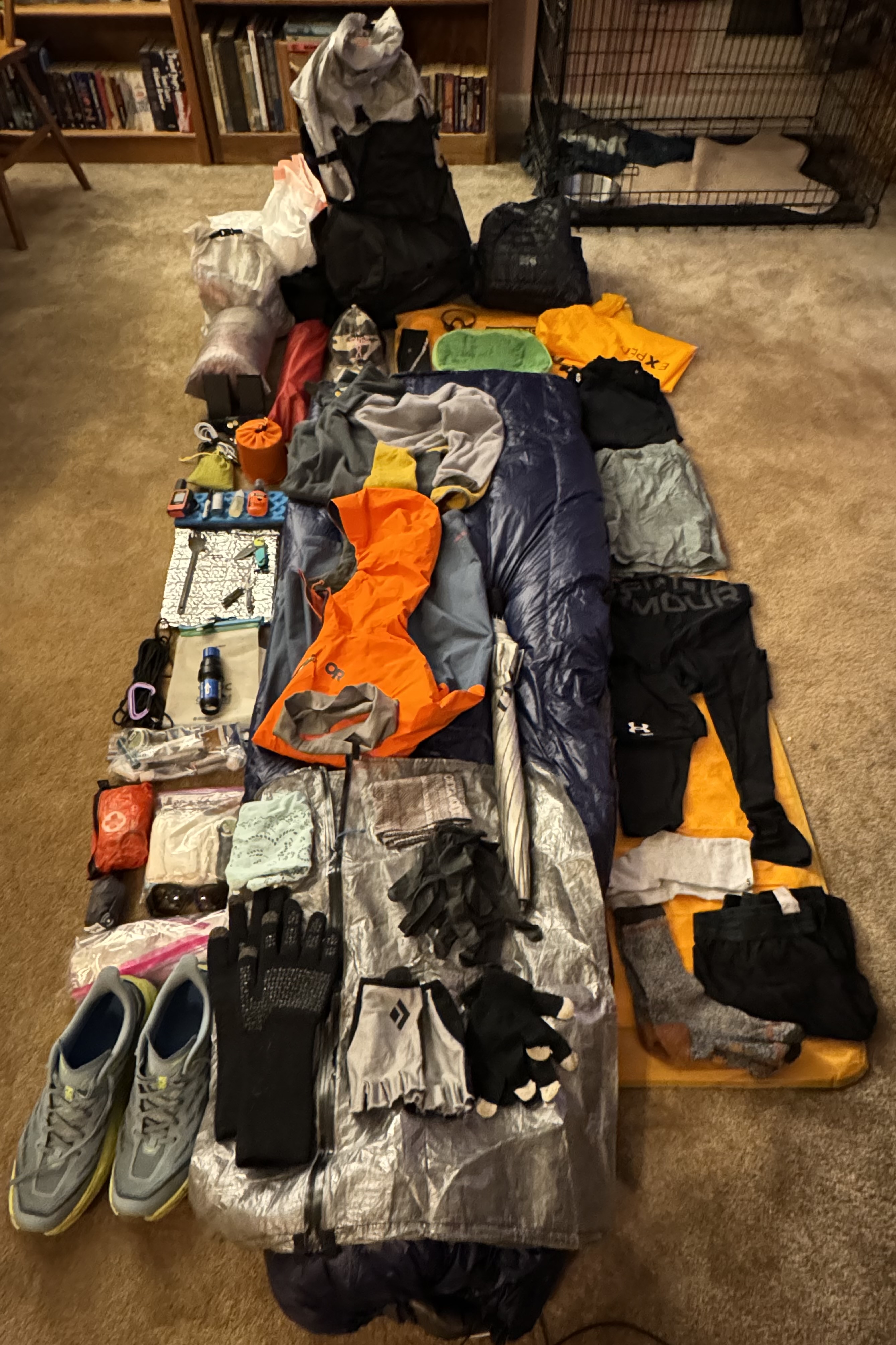
    Gear Overview

    Everything that I need for 5-6 months on the trail, not counting  consumables, will be carried on my back. That means I need to be very careful in choosing what to take with me, what not to take with me, and how to plan and manage my gear and consumables (food, water, fuel, meds, toiletries, etc.). I have a complete gear listing on a later blog page, but I am including some major highlights here based on questions that I am frequently asked.

    Shelter – MSR Hubba Hubba 2 two person free-standing tent that weighs 2.8 pounds. Very roomy and very dry. Been using this for the past year.

    Sleep System – Nemo Tensor Insulated inflatable sleep pad at 19 ounces, Enlightened Equipment Revelation down quilts at 30 ounces for winter and 22 ounces for summer, Sea to Summit Aeros inflatable pillow at 2.6 ounces. I sleep on my side and generally prefer a quilt to a traditional heavy sleeping bag. I have one for clod weather and a different one for warm weather. Will swap as needed. Been using this setup for the past year.

    Backpack – ULA Circuit Ultra 68 liter pack with waist belt pouches and chest strap pouches at 2 pounds 3 ounces. This is an internal frame pack with a fairly sturdy waist belt. I carry a .75 liter water bottle on my right chest strap and my iphone and sunglasses on my left chest strap. Snacks in one hip pouch and frequently used items like bug spray and bandanna in other hip pouch. Just switched to this heavier backpack in January.

    Kitchen – 650ml titanium pot with lid, a long handled spoon, MSR Pocket Rocket stove, isobutane fuel canister, misc items all at a pound.

    Clothes – one long sleeved shirt, one short sleeve shirt, one pair of long thermal underwear, one pair of shorts for sleeping, one pair of convertible pants (turn into shorts), three pairs of socks (one just for sleeping), one spare pair of underwear, light-weight fleece pull over.

    Rain gear – umbrella, rain kilt, heavy rain jacket, two pairs of  8 mil Nitrile gloves.

    Electronics – iphone, Garmin InReach Mini satellite/GPS communicator, two 10,000ma power banks, headlamp, iPad mini. Originally I had just planned on taking a Kindle at 7 ounces, but Dana had a spare iPad mini at 11 ounces which will make blogging much easier and I can read books on it. Decent trade off for the extra 4 ounces. The two power banks can recharge my iphone from 0% to 100% a little over two times each. I go through about 50% of iphone battery daily while on trail due to audio books or music.

    Note on clothes and hygiene….basically I have one set of clothes to hike in and one set to sleep in. I hope to be able to get a shower and do laundry about once a week or so.

    Why is weight so important on the trail?

    I cannot stress enough how important managing weight is on a long hike. By weight I am refereeing to how much weight you are carrying, not how much you weight. There is a direct correlation between people who carry less weight on the trail and successfully completing a thru-hike. People who carry less weight have a much higher success rate than people who carry more weight. 

    “Base weight” is the weight of all of your gear minus consumables like food, water, and fuel. You’re generally considered an ultralight backpacker if your base weight is under 10 pounds and a lightweight backpacker if your base weight is under 20 pounds. Most traditional backpackers will have a base weight under 30 pounds.

    “Total Weight” is your base weight (all your gear including your cell phone) plus the weight of all your food , water, and fuel (i.e. your consumables). 

    Water is heavy. One liter weight 2.2 pounds. Food is also heavy. The general rule of thumb is 2 pounds of food per day. That said, there are plenty of ways to make food lighter without sacrificing calories. Think calorie dense food with zero or minimal water content that you can rehydrate at meal time. I personally find that I can get by on 1.5 pounds (24 ounces) per day with careful planning.

    I spent a LOT of time researching, planning, testing, failing, re-planning, re-testing and continually paying attention to the weight that I am carrying. At 55 years old with lots of hard miles on my lower body and back, weight is everything. Also, ounces quickly add up into pounds. For example, I literally cut my tooth brush in half to save 1.5 ounces. 

    In my opinion, anything over 20 pounds base weight or 30 pounds total weight is asking for trouble. 

    My starting base weight for this AT thru-hike is 19.8 pounds which includes 1.5 pounds of cold weather gear that I will ditch after the first 30-40 days. 

    I carry a 1 liter water bottle and a .75 liter water bottle for 3.85 pounds of water. I prefer to only carry 2.5 days of food at any one time or about 4 pounds. There are plenty of times where I need to carry 3 days of food at about 5-5.5 pounds and a few (3 I think) where I will have to carry 4 days of food at 6.5-7.5 pounds (not looking forward to those). And lastly, I carry one small fuel canister for my stove which weighs 7.5 ounces when full. 

    That makes my total weight for a 2.5 day section of trail roughly 28.5 pounds or 27 pounds once I ditch my cold weather gear. That assumes that all my gear is dry and I am not dragging around couple of pounds of water logged tent and clothes!

    I am not in love with my base weight, but I can live with it. I was down to about 16 pounds last fall, which I thought was great. But that was using some ultralight gear that my older body just was not happy with (not enough  support and some other physical problems). Fortunately I hiked A LOT with that gear and learned that sometimes physical comfort/necessity outweighs weight 🙂

    One caveat on that body weight topic. All weight has an impact on your feet and legs, including the body weight you are carrying. I worked hard to drop 20 pounds of body weight before my AT thru-hike because it is hard to drag that extra weight up and down steep mountains for days on end.

    Where to spend the night on the trail?

    There are shelters along most parts of the trail spaced roughly 7 to 12 miles apart. Shelters are three-sided structures that provide basic protection from the elements. One side is left open to the elements and you set up your sleeping kit on a wood floor. They range from small and basic with room for 4 people to sleep to large and fancy with porches, picnic tables, fire pits, swings and room for up to 16 people. There are locations to set up your tent at/around the shelters ranging from a few tent sites to 40+ tent sites. Many shelters (most?) have a privy (crude semi-outdoor toilet facilities) as well as some mechanism to keep your food away from bears and other animals (bear boxes, bear poles, bear cables). 

    In addition to shelters, there are sometimes official camp sites that have specific locations for setting up a tent. These may have a privy and food storage mechanisms. There are lots of unofficial camping locations with room for anywhere from 2 to 8 tents but no other facilities. Camping at one of the unofficial camping spots is known as “stealth camping” or “dispersed camping”.

    There are a lot of hostels along the trail, particularly in the south and again in New England. Hostels range from first-come-first serve bunk rooms that can sleep anywhere from 4 to 20 people, to rentable rooms with 1 or 2 beds, to small rentable cabins with a heating source. They range from very basic to almost luxurious. Hostels generally have some kind of common/social room for the hikers to congregate and socialize as well as a self-service kitchen for preparing your meals. A night at a hostel can range from $25 up to $100 depending your sleeping preference. Most hostels offer showers, laundry, loaner clothes, snacks, and basic food resupply (ramen, Knorr rice dishes, jerky, tuna packets, snack food, etc) for an additional fee. 

    Lastly, there are the traditional motels/hotels available in towns directly on the trail or within a short hitchhike or shuttle ride to town. Think Motel 6 or even non-chain mom-and-pop roadside motels. Those run anywhere from $75 to $125 a night. 

    The FarOut app is the most common tool used by hikers to navigate the trail and to find details on shelters, camp sites, hostels, towns/hotels, drinking water, food resupply, and much more. This is a mobile app for your phone or other computer device and includes comments from hikers (online version of word of mouth). This app is your most accurate and current source of info on the trail.

    In general, my plan is to find a hostel or motel every third or fourth night and sleep in my tent all other times. I will avoid sleeping in shelters, particularly in GA, NC, and TN due to the Norovirus problems on trail in those states.

    Where to go to the bathroom on the trail?

    Most shelters have a basic privy. These are intended for pooping and NOT for peeing. Go find a tree or a bush to hide behind to pee. Bring your own toilet paper.

    The problem with privies, particularly in highly traveled areas and all of the trails in GA and NC in the spring, is that they can fill up, they can smell, people can be inconsiderate slobs, and they can be the perfect place to pick up Norovirus. More on that last item later. 

    Other than privies, what options does that leave? Dig a 6-8 inch deep hole well away from the trail or water sources, and do your business there. Then cover it back up with dirt.  Welcome to the great outdoors and Leave No Trace principles!

    Side note – anything you pack in you need to pack out. Except for some rare exceptions at large parking lots on trail or state parks, there are NO TRASH CANS. 

    Where to get water on the trail?

    In most areas there are plenty of water sources on the trail. The most common are streams, springs, creeks, rainfall runoff, stagnant pool of water under a bridge. When getting water from these sources you should filter or chemically treat the water. Sometimes if the water is nasty enough (think fecal contamination form livestock), you might want to both filter and treat the water.

    The trick with natural water supplies like this is that they can be very seasonal and unpredictable. You need to research water availability constantly and plan ahead. Word of mouth about water sources is the best way to know about water availability on trail. Hiker notes/comments about good or bad water sources in the FarOut app.

    If the trail runs through a state park there will typically be well water of some sort. 

    Roadside gas stations, convience stores, and restaurants are also common locations to get water. Just refill your water bottle from the sink in their bathroom.

    A few important notes about water:

    • Water is the heavy. One liter is 2.2 pounds. 
    • Water availability varies by season. There are lots of good water sources in spring and early summer. But those same sources can be bone dry in the summer and fall.
    • The goal is to strike a balance between 1) how much water to carry versus 2) availability of water on trail versus 3) how hot it is and how much you need to drink. 

    Where to get food/supplies on the trail?

    There are two basic ways to resupply yourself on the trail. One way is to package up your supplies ahead of time at home into resupply boxes and mail them to yourself on the trail. The other is to buy what you can where you can at things like gas stations, convenience stores, Dollar Generals, hostel, outfitters, etc. 

    I prefer to resupply on trail, but there are some locations where it is just easier to ship things to myself than to get a shuttle and go into town and find a store and then get right back on trail. Therefore, I am doing a mixture of both methods. I put together resupply boxes that I will ship via USPS to various hostels as well as a US Post Office or two. These mainly contain food items other things that I will have trouble finding on a particular part of the trail. Also they contain my meds as I don’t want to carry 170 days worth of meds with me.

    My goal is to carry the least amount of food as possible to minimize weight. I also don’t like getting off trail and dealing with hitching or shuttling miles into town to resupply. There are sections of trail where I know I can resupply from a hostel or some store that is less than a mile off trail almost every day or every other day. This is my perfect world. 

    However there are some hostels and towns that don’t have good resupply options and some sections where there are no resupply options. In those cases I will use resupply boxes. For example, when I hike through the Great Smoky Mountain National Park I do not want to carry all the food that I need for 7-8 days! The other resupply option is to get off trail on day 4, get a shuttle and drive 30 minutes into Gatlinburg TN, buy supplies, get a shuttle back to the trail. I want to push all the way through the Smoky Mountains and not get off trail. To solve that, I shipped a resupply box to a shuttle driver who will deliver it to me at Newfound Gap on day 4. 

    I am very fortunate that I have a great support network at home. I made up resupply boxes for the first half of the trail and Dana will tweak their contents as needed and ship them to me at pre-arranged locations as I progress up the trail. 

  • What Is an AT Thru-Hike?

    What Is an AT Thru-Hike?

    “In every walk with nature, one receives far more than he seeks.” – John Muir

    I am attempting to walk continuously for 2,200 miles North Bound (NOBO) from Northern Georgia to North Central Maine along the Appalachian Trail (AT) over the course of roughly 170 days or five and a half months. This type of hike is called a thru-hike

    A thru-hike is when you hike the entire length of a given trail as one continuous hike within a 12 month timeframe. To be fair, the “continuous” part is subject to some debate, as long as you get it all done (and I mean all) in the 12 month timeframe. There may be times when you have to skip a section (think forest fire or extreme weather or logistics or many other reason), but to complete the thru-hike you need to go back and complete any part that you missed within the specified timeframe. 

    Contrast a thru-hike with a section hike. A section hike is, as the name implies, hiking section of a trail. Section hikes vary from a few days to a few weeks to a month or more. Some people hike the entire AT as a series of section hikes over the course of several years or a lifetime. Note that the technical term for these longer section hikes that last more than….say 10 days to several months….are called a LASH. That highly technical term stands for Long-Ass Section Hike. No, I am not making that up. See my FAQ blog for more trail terminology 🙂

    Back to what exactly I am doing…I am ATTEMPTING to thru-hike the Appalachian Trail NOBO, starting at Springer Mountain in Amicalola Falls State Park, GA on April 14 2024 and, if all goes according to plan (like that will happen), summit Mount Kathadin in Baxter State Park, ME on or about September 30, 2024. Note the bold on the word ATTEMPTING.

    For the more visually inclined, the trail looks like this. 

    Appalachian Trail Overview Map

    For my mid-western friends and family who might not have a good feeling for east coast distances, this is equivalent to walking from Washington DC to Kansas City, MO and back….with a bit more hills.

    I will be starting alone/solo. However, there are a lot of people on the trail starting at roughly the same time, so I will not be “alone”. Far from it. Mid-March through Mid-April is one of the most popular NOBO starting times. Here is the graph showing the number of people who registered their start dates in the spring of 2024 courtesy of the Appalachian Trail Conservancy (ATC).

    For example, there were over 80 people who registered to start on April 1, and not everybody who hikes bothers to register! That denser cluster of northbound thru-hikers is called “the bubble”.  Like a soap bubble, it can expand and contract over time and even break into several smaller bubbles. There will be many hundreds of people in the bubble…..at least initially…more on that later. There is a great Web site called Where Are The Hikers that allows you to visualize where the bubble is on the trail at any given time based on 15 years of historical data. Note, this is aggregated data NOT real-time data.

    What does that mean for me? I am intentionally starting towards the end of the traditional “bubble” on April 14, 2024 for two reasons. 

    First, I want to minimize, not eliminate, my time lugging a 30 pound backpack through 20-35 degree weather being pummeled by snow, sleet, and really cold rain for days at a time. Don’t get me wrong, I love hiking on a crisp winter day with a reasonable amount of snow (2-6 inches). But if I can avoid freezing my ass off on 15 degree nights with howling winds, no camp fire and nothing but a flimsy tent and a sleeping bag, then I am all in! The trail in Georgia and  North Carolina, particularly in the Smoky Mountains, is just not fun in the winter or very early spring. Especially when you are out there for many days at a time with no break. IMHO it can be downright dangerous.

    Second, many of you know, my great love for being surrounded by masses of people knows no bounds. Not! While I have spent a week on the trail and seen only one or two people a day and had entire camp sites to myself, that is a bit too in-peopley even for me. At least for 6 months. 

    Starting mid-April strikes a balance between the cold wet early spring in the south and the masses of people hiking at the height of the bubble. 

    Why not start even later and enjoy fewer people and warmer weather? The answer to that is that the northern terminus of the trial at Mount Katahdin in Baxter State Park Maine closes for the season depending on when the heavy snows arrive. For example, in 2023 the park closed on 10/21/2023 for the season. The guidance from the ATC is to make sure you are done with your NOBO thru-hike by October 15. Starting on April 14, hiking at a reasonable pace (starting slow and increasing mileage over time), and estimating 170 days to reach Mama K (Mount Katahdin) equates to October 1. That gives me two weeks of buffer time before October 15 in case I run into any delays on the trail. 

  • Why The Appalachian Trail?

    Why The Appalachian Trail?

    “Life is not tried, it is merely survived if you’re standing outside the fire.” – Garth Brooks & Jenny Yates

    After my wife died in 2021, I had to deal with that whole “mortality” thing and I did not like what I was seeing. I had not done any exercise since I stopped playing soccer about 6 years prior and I got winded walking up one flight of stairs. I also looked back on the past 30 years and realized that I had a lot of regrets. I was a workaholic, which caused me to miss a lot of weddings, funerals, graduations, birthday parties, etc. Add to all that the trauma of loosing my partner of 35 years and general depression around trying to figure out what the hell do I do with my life, and I decided that I needed to make some major changes.

    I retired on January 3, 2022 at 53 years old and started working on Life Part II. A major part of that included my desire to become much more healthy as well as to NOT putter around the house in my retirement. I wanted to get to a physical and mental place where I could truly enjoy life, try new things, and challenge myself. I have never enjoyed exercise for the sake of exercise (i.e. going to the gym). I decided to embrace hiking for the health/exercise benefits plus the “Spiritual” side of things. 

    I started off with 1.5 miles being difficult. Fast forward two and a half years…I have lost 25 lbs, I hike 30-45 miles a week with a 28lb pack on moderate-to-difficult terrain, and I eat better than I have in years (not a health food nut, just generally better eating habits). I have hiked/explored lots of new areas up and down the mid-Atlantic, and I am enjoying life. At some point along the way I realized that I had become a hiking addict. I love finding ever more challenging terrain as well as that “endorphin high” that comes from pushing my body. 

    I decided that I wanted to really challenge myself physically and mentally. Long-distance hiking looked like a good way to approach that, and a thru-hike of the Appalachian Trail (AT) became my initial goal (obsession?). I spent the second half of 2022 researching an AT thru-hike and doing ever more challenging day hikes to get in shape.

    Unfortunately I tore my metatarsel plate on the decent of McAfee Knob in July 2022 and stupidly hiked on it for 3 more months before seeing a doctor. After 3 months of doctored-ordered no hiking, I finally had surgery to repair the tear. That led to three more months of recovery and no hiking. By April of 2023, I was able to start hiking again. Recovery was very frustrating. Going from hiking 10 miles on difficult terrain to struggling to do 4 flat miles on the C&O Canal Towpath sucked! I started to think that there was no way I would be able to ever do the AT. 

    With the encouragement of my friends (thank you Dana!) and my orthopedist, I stuck with it. I eventually got back to hiking at least 4 days a week and struggled through several 2 day backpacking trips in the summer of 2023. Side note…dropping 25 pounds of body weight sure makes those miles easier on the feet! I capped out the year with a week-long backpacking trip from Pen Mar MD to Duncannon PA in 90 degree heat with 70-80% humidity and the worst drought we had in the mid-Atlantic in a long time (very very little water on the trail). I figure if I could survive that trip, then I was ready to attempt a thru-hike of the AT. 

    As my wonderful sister-in-law Vicki has told me many times (usually as we decide to do something questionable on a black diamond ski slope), that which does not kill us makes us stronger!