Solid uphill workout this morning including an upper body workout. Note the vertical rebar climb.
Vertical rebar climb
Mud bog on top of Mount Success. They are thigh-deep.
Mud bog on top of Mount Success
Summited Mount Success at 10:30 and 3.8 miles in. Hard climb but they all seem to be hard these days.
Yes, that is the trail straight down. Tossed my poles down carefully and slid/climbed down.
Vertical descent off Mount SuccessVertical descent off Mount Success
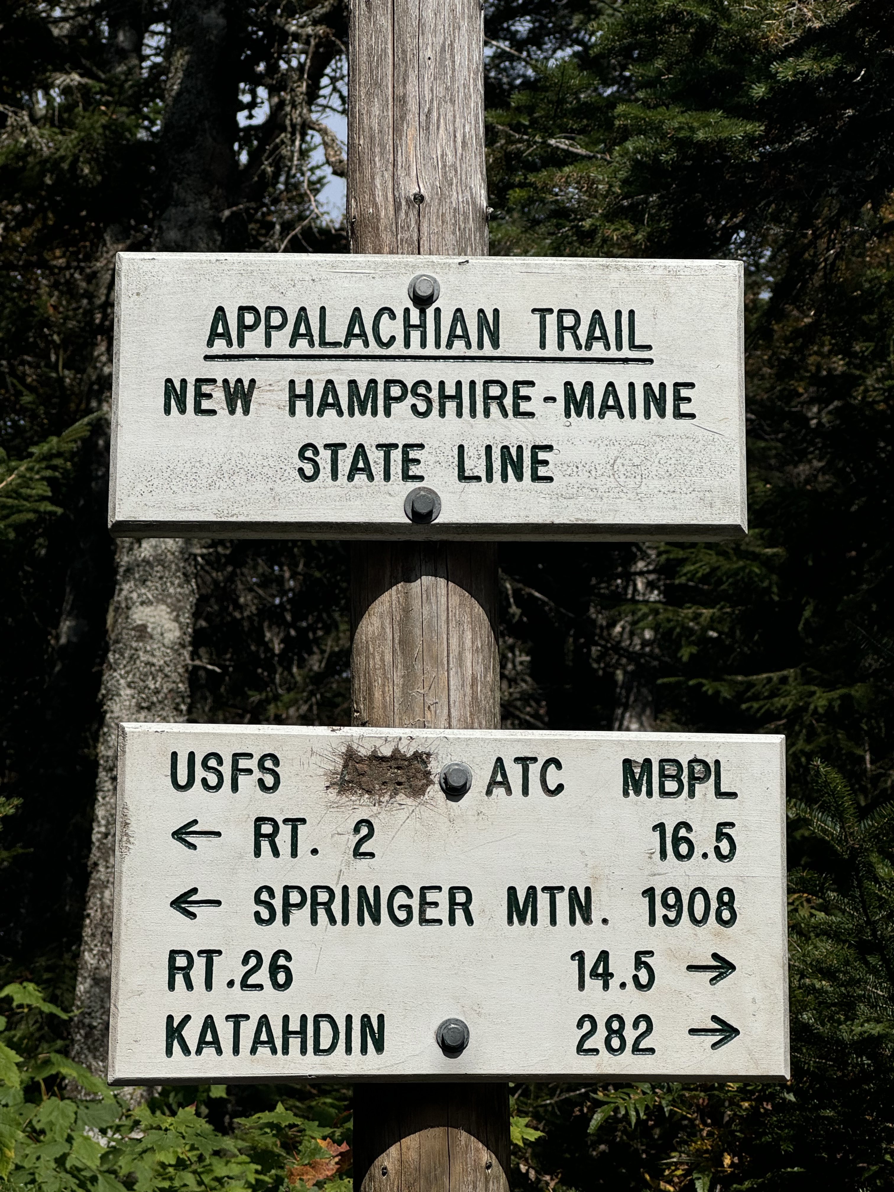
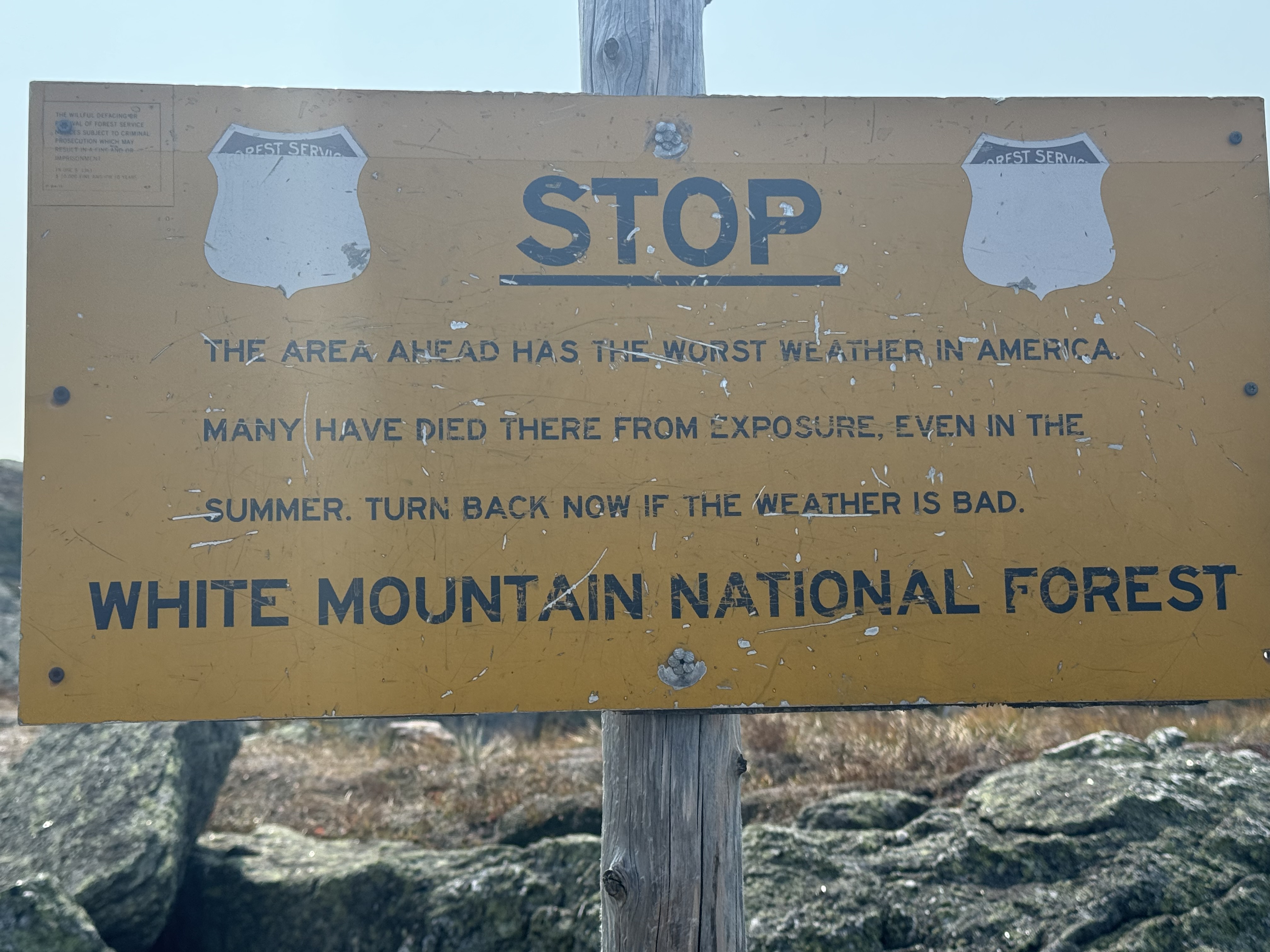
Welcome to Maine. Crossed the border at noon. Got 5 miles to camp assuming I don’t push onward.
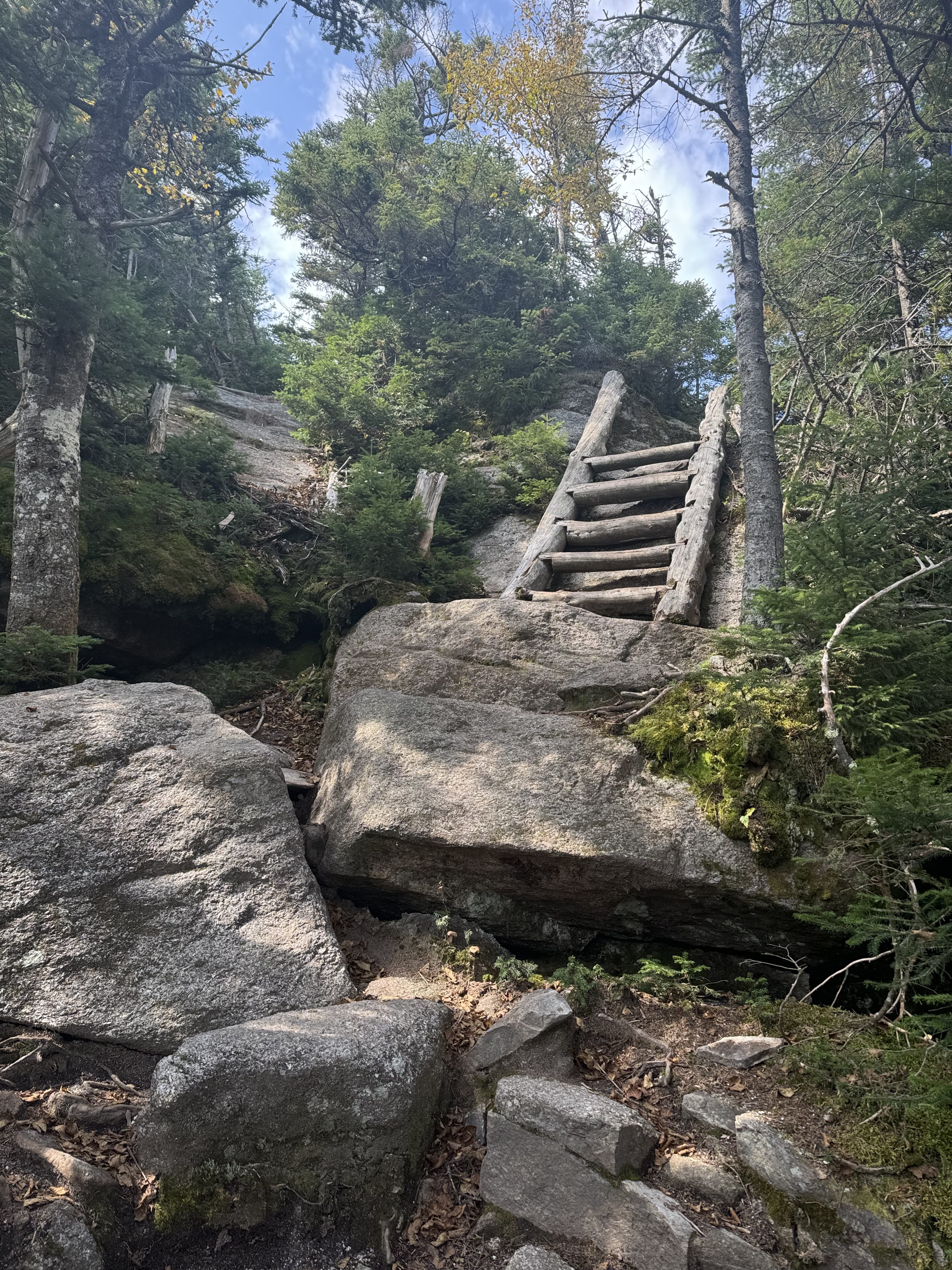
Moss covered wooden ladder in MAINEWelcome to Maine
Took a good fall. Damn slippery rocks. Messed up my right palm on the fall.
Maine is just pissing me off. Now up and over that.
Tough climb coming up
Oh man, now Maine is really, really pissing me off. Vertical climb with rebar ladder followed by steep wooden ladder.
Vertical climb with rebar ladder in MaineVertical climb with rebar ladder in MaineVertical climb with wooden ladder in Maine
Followed by steep ladders down.
Steep wooden ladder descent
Down, across the ridge, up the mountain, and down the far side to camp. You can see the trail across the ridges.
Down, across the ridge, up the mountain, and down the far side to camp
And one more rebar ladder but DOWN , which is scarier.
One more rebar ladder but DOWN
Crawled into Full Goose Shelter at 4:40. Got 2 good bars of cell service. Got camp set up and got water. I nursed my last tiny bit of water into camp. Really needed more water today. All set up and hydrated and dinner ready at 6:15.
Camp at Full Goose Shelter
What a day! Possibly the hardest day on the trail. The group of 8 folks from last night and again today concur. Steep as hell. Big rock scrambles. Slippery rocks. Upper body workouts. Up and down and up and down. The vertical descents are the hardest . Fell 3 times today, with one being a little bad. I guess this is what the next 2-3 weeks of Maine are going to be like. Hard, wild, beautiful.
Dreading the start of tomorrow with Mahoosuc Notch and Mahoosuc Arm. Gonna be damn hard, but Bethel, Maine, and a zero day at the end of the rainbow.
Up at 7:00. Tent is wet from the dew. Nuts:( Got moving slowly, hoping for the tent to dry. No luck. On trail at 9:15.
Sunny, mid-70s, no wind.
Passed a small hydro plant before heading into the woods. Washington and Madison in the background.
Small Hydro Plant near Quantum VortexSmall Hydro Plant near Quantum Vortex
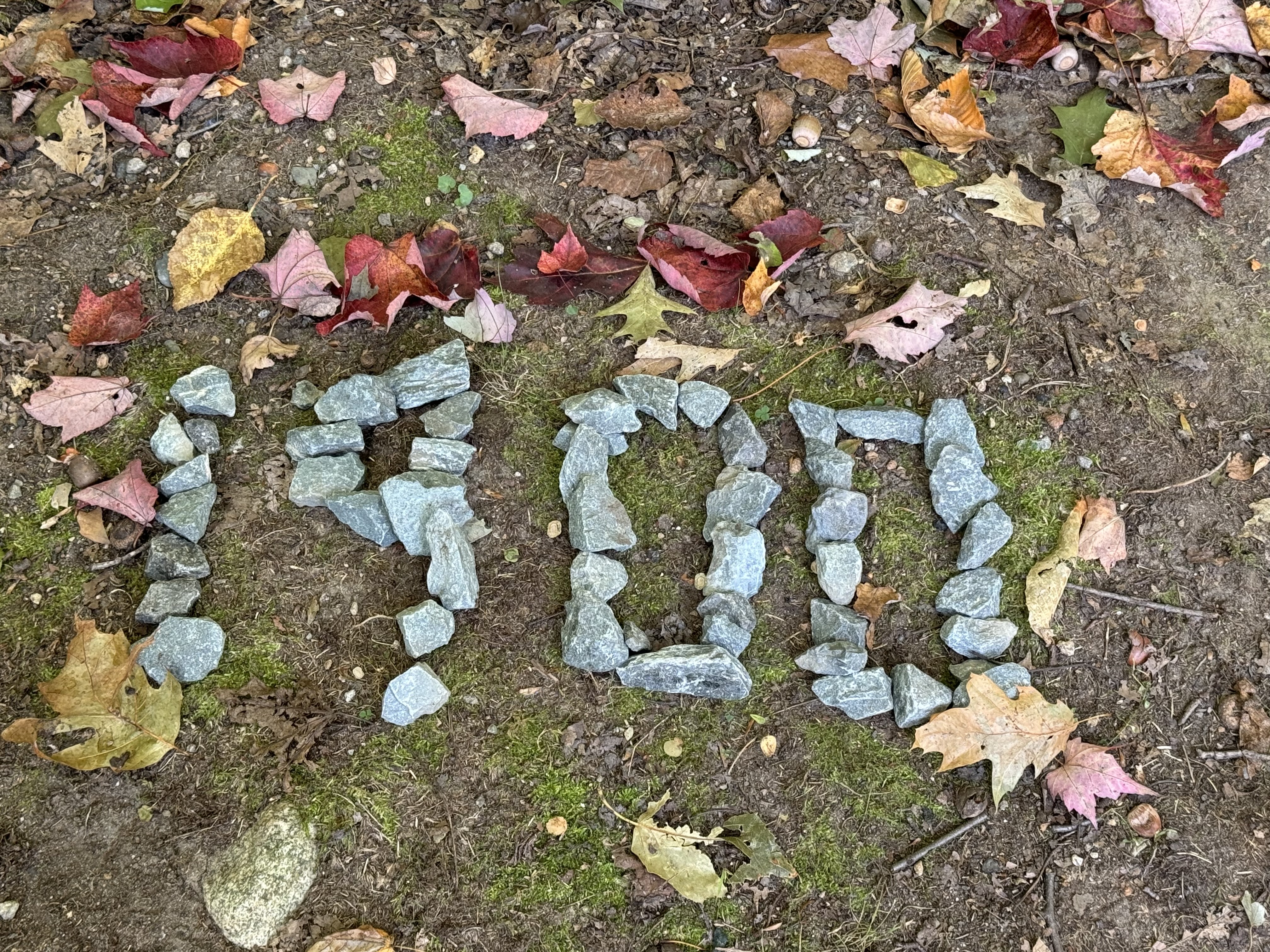
Another major milestone at 1900 miles. The leaves are turning.
1900 Mile Marker
Hard, steep climb the past 3 miles, but not technical. Plenty of rock steps. Wish there was a breeze and cooler temps.
Stopped and chatted with a SOBO, FilpFlop, and a cattle dog at 11:00. Got good intel on what’s coming and gave them intel on the next few days. Once I get to the summit in about .3 miles, it’s not bad until Gentian Pond campsite. From there, I can look down into Mahoosuc Notch and giant boulder fields for many miles.
Put out my tent and bandannas to dry on a false summit of Mount Hayes at 11:30 and 3.5 miles in. Hung out for 30 minutes until everything was dry. Back on trail at noon.
Drying tent on Mount HayesChuck at Mount Hayes
Passed by the summit of Mount Hayes. Got 7.9 miles to Gentian Pond. It’s hot out here!
AT sign near summit of Mount Hayes.
Took a spill on a slick rock. Hurt my wrist, but I’m okay. And now this sucks. That’s almost straight up.
Fell in these rocks. Those are almost VERTICAL
Summited Cascade Mountain at 1:20. Took a snack break and swapped water bottles. Moving again at 1:50.
Took a break and filtered water at a pond at 3:15. Very picturesque.
Pond after Cascade Mountain
Summited Wocket Ledge at 3:55. Still have 3.2 miles and one more PUD to go. Gonna get to camp later than I want, but not too late.
Got to Gentian Pond Shelter at 5:50. Crowded. One guy in a big shelter and a dozen tenting but not enough tent spots. Glad I got here a tad early. Got set up, filled up on water, and made dinner by 7:00.
Dana dropped my next package at FedEx, and it will meet me in Bethel, Maine, on Wednesday. Sweet!
Today was a hard workout. Lots of steep, hard climbs and an annoying amount of damp, slippery rocks. Fell twice, and one was almost very bad. Tomorrow and the next day are harder. Got Mahoosuc Notch followed by Mahoosuc Arm. Mahoosuc Notch is the hardest mile on the AT. I’m hoping to do that late tomorrow, but it depends on what time in the day I can get to the start of it.
They’re woven in the stories I have told, and tell again” – Tim McGraw
Up at 6:40. Nice warm night. On trail at 8:00.
Upper 70s, sunny, light breeze. Just another perfect September day in the White Mountains.
I love the clouds down in the valley views.
Clouds in the valley in The Whites
The ascent was challenging and got the blood flowing. Long steep slabs of rock with intermittent rock scrambles. Would not want to do that in the rain or with worn-out shoes.
Steep ascent of Mount Moriah
Passed the summit of Mount Moriah at 9:30 and 2.4 miles in. I’m saying goodbye to Mount Washington and the presidentials. A bit sadly. I’ve been looking at them for the last week. Now that I’m on the other side of Mount Moriah, I’m looking north into Maine and the final parts of the Whites and then the Mahoosuc Mountains. Those are my next challenge.
I’ve got about 6 miles all downhill to the tent site for tonight. I’ll get in early, 2:00-3:00, but the next camp spot would be very late in the day and I want to do a resupply in Gorham and get real food for dinner.
Lots of bog boards this morning at altitude.
Bogs and boards at high altitudes
There were a pair of technical areas on the way down, but not terrible overall. Stopped at Rattle River shelter for water and a snack at noon and 6.3 miles in. Zero cell service. Got an easy 2 miles to go to US Route 2.
Rattle River shelter
Got to the Quantum Vortex campsite at 1:30. Nice package: tent site, laundry, shower, WiFi, shuttle to town, all for $35. Also, they provide a small Jackery battery bank. It’s about 6 inches cubed and has two USB-C ports. Perfect for recharging my electronics. I have one of the BIG Jackery power banks at home for emergencies, but I’ve never seen these mini ones before.
The weather is sunny and warm with zero chance of rain, so tenting right on the trail with the amenities is perfect. I’ll go into town at 5:30 and grab minor supplies, adult beverages, and dinner from Subway. In the interim, I’m all set up for the night, and I’ll shower and work on blogs.
The staff is very friendly. There’s a definite hippy vibe with a lot of pot, but I was expecting that. Things seem clean and fairly neat, especially for a small campground, so I’m happy. Plus, there is a covered picnic table away from the big fire pit and party area right by my tent. Nice!
They have a very large campfire area and several covered picnic tables. Perfect for this weather. It’s almost 80 right now.
Quantum Vortex campsiteQuantum Vortex campsite
As I was walking up to the Vortex, I saw a bunch of SOBOs trying to hitch to town. As I got closer, I realized one of them was Mosey. I was hoping we would cross paths. She flipped up to Maine at the end of PA. It was good to chat with her for a bit. She is hiking on a cracked ankle since 2 days ago. Not fun. She plans to keep on moseying south to finish the AT at the Delaware Water Gap, where we parted ways with her back in late July.
Drove to town at 5:30 and got supplies and dinner. Back to campsite, ate dinner, watched YouTube till after dark, talked to Dana, prepped food for the next 3 days, and settled into read till sleep time.
Nice Nero day today. Looking forward to getting to Bethel, Maine in 3 days and really taking a day off.
“You’re just as wild as a wildcat and you got your claws in me
Scratchin’ out my poor old heart and slowly killing me
I’d like to break your pretty neck but what good that it’d do
You’re gonna get the best of me just like you always do” – Charlie Walker
Up at 7:00. Packed, walked to the gas station for coffee, updated blogs, and did a little backpack maintenance. Shuttle picked me up at 9:00.
Made hotel reservations for my Zero in Bethel, ME Wednesday and Thursday this week. Spoiling myself a bit 🙂 Also ordered shoes and a new knee brace. Need to figure out where to have Dana ship each.
Sunny, low 70s, chance of scattered showers.
Took the Wildcat ski lift up to the top of Wildcat D at 10:00 a.m. Beautiful day.
Steep, rocky, slippery ascent up Wildcat Mountain, tough climb.
Steep, rocky, slippery ascent up Wildcat MountainSteep, rocky, slippery ascent up Wildcat Mountain
Summited Wildcat at 11:45. Now I gotta go down there to Carter Notch.
Summit of Wildcat looking down into Carter Notch
And then up there to Carter Dome
Carter Dome
Gonna be a long afternoon! It’s 11:50 and 2.1 miles in. Let’s see how long it takes me.
Took about 40 minutes to climb down here 1 mile from up there. Not too bad a descent. Really beautiful alpine ponds with steep cliffs back up to Wildcat Mountain.
Alpine ponds in Carter NotchAlpine ponds in Carter Notch
Stopped at Carter Notch Hut for water and a short break. The crew member on duty said it should be about an hour hike to summit Carter Dome. Back on trail at 12:55.
Carter Notch Hut
This is a tough climb.
Nasty ascent out of Carter NotchNasty ascent out of Carter Notch
Looking back down (very down) at Carter Notch from partway up Carter Dome.
Looking back down at Carter Notch from partway up Carter Dome
Summited Carter Dome at 2:10. Heck of a climb, but not quite in the top 5. I have 5.8 miles to go and I really want to be to camp by 6:00 at the latest. Gotta move!
Summited South Carter Mountain at 3:40. I’m beat. All these climbs today are adding up. Steep and rocky and steep! One more big climb to go and 3.9 miles. I’ll be lucky to get to camp by 6:00.
Summited Middle Carter Mountain at 4:35. Just another spectacular view. Whatever;)
Summited North Carter Mountain at 5:10. I’m beat. I have 1.8 steep miles down to camp. This descent is brutal. Super steep, slippery, shadows, and rock climbing. I hate doing these descents this late in the day as it’s easy to fall and nobody is around to help at this late hour.
Brutal descent of North Carter Mountain
Made it to Imp Campsite at 6:20. Got camp set up very fast so I could have some light to cook dinner. Chatted with 5 overnight hikers while having dinner. Finished dinner in the dark at 7:20. Finished setting up my sleeping gear after dinner and settling in for the night at 8:00.
Today was hard. Only 3316 feet elevation gain but 4082 of descents. Steep and slippery and long. I hate getting into camp this late due to lack of daylight and having to rush. There were some spectacular views today plus a lot of day hikers. The Wildcats and the Carters lived up to their nasty reputation. This was the hardest hike in the Whites.
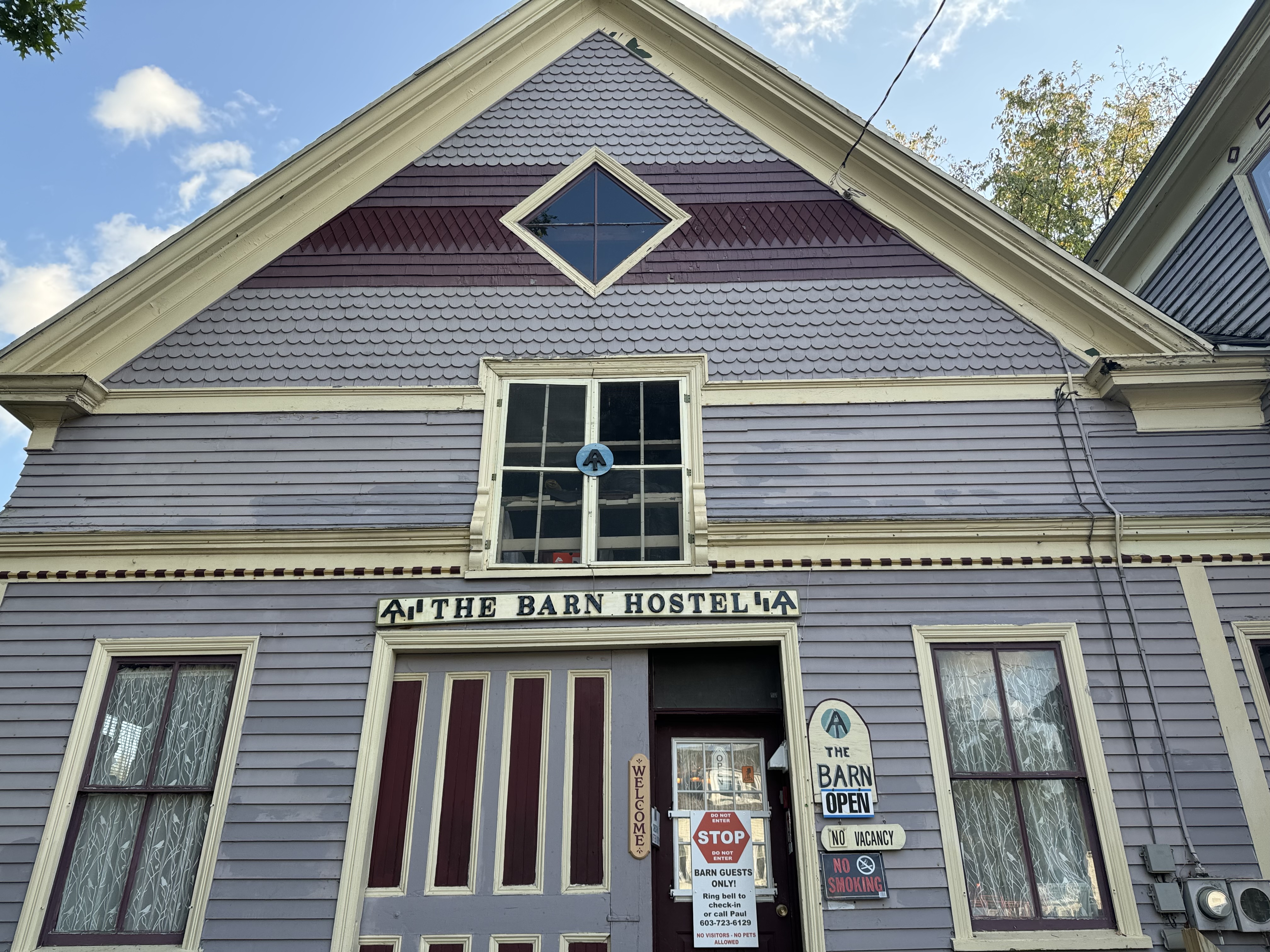
Called The Barn hostel and made a reservation. Bad phone connection, but I think I’m good.
Looking back at Mount Adams and Washington. Cool clouds.
Looking back at Mount Adams and Washington
Auto road going up Washington.
Auto road going up Washington
Dropped below tree line and exited the presidentials at 9:45.
Reached Osgood Campsite at 10:40. Cool bridge and waterfall.
Bridge near Osgood CampsiteStream crossing near Osgood Campsite
Stopped at the Mount Washington auto road at 12:30. I have 1.9 miles to go. This has been a very rough hike as advertised. Very rocky, steep, tons of tree roots below tree line, etc. At the end of the day, 7.8 miles will take me 6 hours.
Descent into Pinkham Notch
Arrived at Pinkham Notch visitor center at 1:50. Call it just under 6 hours for the 7.8-mile hike today. Shuttle will be here at 2:30. Cool relief map of the Whites! I’ve hiked the vast majority of it so far.
The Barn hostel
Checked into The Barn hostel at 3:00. Cool place. They are closing for the season on Monday. The owner said it’s his worst season ever, hence the early close. Gravy and Sprawl decided to stay here also. I’m contemplating a zero. My knees are beat up after the last 5 days plus my fall today.
The Barn hostelThe Barn hostelThe Barn hostel
Got my plan for the next 6 days figured out. The only wild card is if I take tomorrow off or not. I went to the gas station market across the street and resupplied for the next 3 days at which time I’ll do another small resupply if necessary. I showered and did laundry. I REALLY needed the laundry. I smell bad. The weather has been warm-to-hot and sweaty. It’s near 80 today! WTF.
Did the Friday happy hour video call with Jon and Trish and company. Very nice. I went to dinner at a local brew pub with Sprawl then talked to Dana for quite a while.
Overkill was here tonight. She is 2 days ahead of me and came in here from the other side of town. The AT loops around Gorham.
Good day overall. I need to figure out my plan through the Wildcats and into Maine.
Day 153 Map – Madison Springs Hut to Pinkham Notch
“I am, I am, I am Superman and I know what’s happening
I am, I am, I am Superman and I can do anything” – R.E.M.
Up at 6:00. Good night’s sleep. Had breakfast at 7:00. On trail at 8:00.
Mount Washington summit forecast is 55 degrees, 5 mph wind, sunny. It doesn’t get much better than that this time of year up there! Awesome!!!
Rest of the day it’s going to get to low 70s with a light breeze and mostly sunny.
Entered the Presidential Range. The Presidential Range of the White Mountains is the highest range of mountains in the Northeast and is home to the largest above-treeline alpine zone.
Summited Mount Pierce at 8:30. It’s very warm with zero wind. That’s my climb for the next several hours to Mount Washington.
Mount Washington from summit of Mount Pierce
Clouds in the valleys and cairns to mark the way.
View from summit of Mount PierceCairn on Mount Pierce
Stopped at 9:50 for a snack. I wish it were a little cooler. I still can’t believe this weather!
Here is a view back where I hiked from this morning. You can see the trail across the bare rock is an S-curve.
Looking back from Mount Eisnehower
Summited Mount Franklin at 10:30. Hard climb the last mile but not too bad.
Little Monroe on the left and Monroe on the right with a view of Mount Washington through the saddle.
Little Monroe on the left and Monroe on the right with Mount Washington through the saddle
Onwards and upwards to Washington.
Ascending Mount WashingtonAscending Mount Washington
Reached Lakes of the Clouds Hut at 11:05. Stopped for water and a snack. I have 1.4 miles to the summit of Washington and then another 5.7 miles to Madison Springs Hut. I’m guessing I’ll get to the hut about 5:00 this evening. Back on trail at 11:25.
Lakes of the Clouds Hut
The ascent up Washington begins
Mount Washington Warnign Sign
Just following the cairns. Notice that instead of painting white blazes, they try to tip the cairn with a piece of white quartz. Cool.
Following cairns up Mount Washington
Looking back down from the midpoint of the ascent at Lake of the Clouds and Mount Monroe at noon. Got .6 miles to the top.
Looking abck at Lakes of the Clouds from midpoint up Mount WashingtonLooking abck at Lakes of the Clouds from midpoint up Mount Washington
Summited Mount Washington at 12:22! Oh yes!
Chuck at summit of Mount WashingtonChuck at summit of Mount WashingtonWeather station on Mount Washington
Good picture of the cog railroad that you can take to the summit from below Lake of the Clouds.
Mountains after mountains as far as the eye can see. And at this altitude, I can see a long way.
View from Mount Adams
Finally passed over the top of Mount Adams at 4:25. I feel like yelling “Light the beacons of Gondor”!
“Light the beacons of Gondor”!Summit of Mount Quincy Adams
Passed by the summit of Mount Quincy Adams on the final descent to the hut.
Arrived at Madison Springs Hut, at the base of Mount Madison, at 4:55. That last 2 miles was tough, but not terrible. Got changed into dry clothes, cleaned up as best I could, and laid my clothes out on a rock to dry. Lots more people at this hut tonight. My bunk room sleeps 9 and only 2 bunks are open at the moment.
Madison Springs Hut at the base of Mount MadisonMadison Springs HutDrying clothes at Madison Springs Hut
Gravy and Sprawl are both doing work-for-stay here tonight.
Nice dinner and conversation. Trying to plan my day tomorrow. The hike looks brutal based on comments from other hikers including Overkill. It’s 7.3 miles and I’m planning 7 hours. Trying to arrange a shuttle pickup at 3:30 tomorrow. Waiting to hear back. Not sure how well this will work. I have a hostel option and a motel. Prefer the hostel, but need to call tomorrow as they don’t do text messaging. I have a lot to plan out for the next week. Need better internet service to do that. Stressful.
Overall, amazing day. The hike from Washington to Madison Hut was long but not bad. Took 3.5 hours. Rocky, but done worse.
Up at 7:00. Broke down camp and on trail at 8:15. Short 9.2-mile day today. Big climb, but shorter day.
Clear, low 50s going up to low 70s.
Easy hike down to US 302. Arrived at 9:30. Had a snack and got ready to climb that.
Crawford Notch US 302Crawford Notch US 302
I’ve got 332.4 miles to reach Katahdin. Woo hoo!
Mile sign in Crawford Notch
The ascent up Mount Webster is very tough. This is one steep, rocky mountain.
Ascent up Mount WebsterAscent up Mount Webster
Great viewpoint overlooking US 302. First cell signal since yesterday afternoon, so I called Dana and chatted for half an hour while looking out at this view.
There is my destination for tonight. That building in the lower left. About 1.7 miles and 1.5 hours away.
Mizpah Hut from Mount Jackson
And now we have a bog at this altitude. Really?
Bogs and boardwalk after Mount Jackson
Arrived at Mizpah Hut at 3:30. Got checked in and had a snack. Very nice facility and super friendly staff.
Mizpah HutMizpah HutMizpah Hut
Only 3 of us in a bunk room for 8. Decent beds with pillows and 3 heavy wool blankets. Nice to not have to unpack my sleeping gear. If it weren’t for the 20-person youth group (10-12-year-old school kids), this place would feel fairly empty.
Gravy and Sprawl are here. Been hiking around them the last 5 days. They are doing work-for-stay tonight. They do 1-2 hours of chores and are allowed to spread out their bed rolls on the floor in the common room, and they get leftover food for dinner. They have to be out before breakfast time tomorrow morning.
Gravy and Sprawl at Mizpah Hut
Hung out with these guys and talked for a couple of hours until dinner time at 6:00. Very good dinner. I had seconds and thirds. Working on that calorie deficit. Hung out and talked with table mates until 8:00. Very good Hut experience.
Had dinner with a female section hiker from Bethesda who graduated from Poolesville in 2005. Small world.
Today was another awesome day. Doing this kind of hard hiking with these mountain peaks and these views is exhilarating. It’s like a drug. It actually is a drug…massive endorphin rush. Hard to explain the feeling, but it’s great!
I’m so tired I don’t know what to do.” – The Beatles
Up at 6:00. Raining. Went back to sleep till 7:00. Rain stopped. Got packed and on trail at 8:00. Long, hard day today.
Sunny, with a high near 52. Northwest wind 15 to 20 mph, with gusts as high as 35 mph. New rainfall amounts less than a tenth of an inch possible.
Arrived at Galehead hut at 9:55. Bought a piece of cake and tried to dry my tent a bit. Topped off water and used the bathroom. Back on trail at 10:15.
Galehead Hut
Summited South Twin Mountain at 11:05.
Summit of South Twin Mountain
Summited Mount Guyot at 12:15.
Summit of Mount GuyotSummit of Mount Guyot
Nasty, rocky, steep hike down to Zealand Falls in about 5 miles. Very hard on the knees all afternoon.
Summited Zealand Mountain at 2:30. Stopped at Zealand Hut and dried out my tent, refilled water, and had a snack. Back on trail at 3:10. Got 4.9 miles to go.
Last 4 miles into camp for tonight is a fairly easy trail, just long.
Lasdt 4 miles to Ethan Pond ShelterLasdt 4 miles to Ethan Pond ShelterLasdt 4 miles to Ethan Pond Shelter
Arrived at Ethan Pond Shelter at 5:15. Gorgeous view of the pond.
Ethan Pond Shelter
Got camp set up quickly and ate dinner. Today wiped me out and my knees aren’t happy. Not surprised with 4200 feet of rocky, steep descents. I have not been this exhausted since Virginia. In my tent and in my quilt by 6:30. Asleep by 7:30 p.m.
Day 150 Map – Garfield Ridge Campsite to Ethan Pond Shelter
“I’m on the top of the world looking down on creation
And the only explanation I can find
Is the love that I’ve found, ever since you’ve been around
Your love’s put me at the top of the world” – The Carpenters
There’s an old saying about the White Mountains during a northbound thru-hike attempt. It says you have completed 80 percent of the miles, but you have only spent 20 percent of the energy you’ll need to complete your thru-hike. Let’s see how true that is.
Up at 6:00. Ate breakfast and finalized yesterday’s blog. Finished packing and shuttled from hostel to trail at 7:15.
Crap! Forgot my earphones so had to go back to hostel and get them. Took an 8:00 shuttle back to trail, first time I forgot something in over 1800 miles! On trail at 8:30.
A chance of rain showers after 4 p.m. Mostly sunny, with a high near 53. West wind 20 to 30 mph, with gusts as high as 50 mph. Chance of precipitation is 30%. 40% chance of rain showers overnight with low of 40.
I’m not wild about this new weather forecast, but it could be worse. Wet gear tonight and tomorrow morning will suck.
The climb up to Mount Liberty was a steep climb, but just big rock steps. No rock scrambles. Easier than 3 days ago ascending South Kinsman.
Steep rocky ascent of Mount Liberty
Passed by Liberty Springs campsite at 10:30 and 3.5 miles (2.5 on AT).
Liberty Springs campsite
Reached Franconia Ridge at 11:00. Steady wind with frequent gusts, partly cloudy. Franconia Ridge, from the summit of Little Haystack to Mount Lafayette, is New Hampshire’s second-highest range, after the Presidential Range. The climb from Liberty to the start of Franconia was about the same as the climb up to Liberty, but not quite as steep. Once up to Franconia and moving above the tree line, everything changes.
Franconia Ridge Map
The ridge is a rocky, windswept ridge walk with good-sized ascents and descents for each of Little Haystack Mountain, Mount Lincoln, and Mount Lafayette. I had 40-50 mph wind and 80 mph gusts, and that is a mellow day up here. Even with the wind and cold, I was in short sleeves and shorts. The physical exertion kept me plenty warm. Most day hikers are massively bundled up.
Summit of Mount Lafayette
Summited Little Haystack (4755 feet) at 12:15. About 8 people and a dog were up here. It’s just amazing up here. Pictures below are looking back at Liberty Mountain and then ahead at Mount Lincoln.
Looking back at Liberty MountainChuck on summit of Little HaystackLooking ahead at Mount Lincoln
After Little Haystack, there was a ridge walk to Mount Lincoln.
Ridge walk to Mount Lincoln.Day hikers ascending Mount Lincoln
The descent is harder than the ascent. Once below the tree line, it gets even harder. This thing is almost vertical.
Descending off Franconia RidgeDescending off Franconia RidgeDescending off Franconia Ridge
Passed by Garfield Pond at 3:45 while ascending Mount Garfield. My feet and knees are really talking to me after this descent and then ascent up Garfield.
Reached the summit of Garfield (4467 feet) at 4:20. Awesome view looking back across the valley at what I climbed and hiked today.
View form summit of Garfield
Reached Garfield Ridge Campground at 4:50. Set up a tent and had dinner by 6:10. Chatted with some section hikers and one NOBO while having dinner. It’s getting cold fast, so I crawled into my quilt by 6:15.
I averaged a little under 1.5 miles per hour today. I’ll use that as a baseline for planning the rest of my hikes in the Whites. I made my reservations at Mizpah Hut and Madison Spring Hut for Wednesday and Thursday, respectively. Lakes of the Clouds Hut was booked.
It’s hard to describe today. A lot of AT hikers don’t get blue sky days like I have been having. The hike across Franconia Ridge and over four 4000-footers including 5246 feet for Lafayette was amazing. I can’t put into words the exhilaration of getting up here and experiencing the sights, sounds, the wind, just everything. The views are spectacular. Just being physically able to do this is a rush. An older local hiker passed me and said that your first time up here is a once-in-a-lifetime experience. Return visits never measure up to the first time. What an amazing day, with the Presidentials yet to come later this week.
Day 149 Map – Flume Visitor Center to Garfield Ridge Campsite
Up at 7:00. Finalized route plan which lets me finalize my shopping list for the next 5 days in the Whites. Had a light breakfast of Chinese leftovers, did some chores, and got ready to bike 1.3 miles into town for resupply and some more breakfast.
Biked into town. Very quiet in town on a Sunday morning. Did my resupply shopping at the gas station market. I’m all set for the next 5 days including a huge roast beef sub for dinner tomorrow night in camp. Had a REAL breakfast at the Big Inn and Brew House in town (steak and eggs). Biked back to the hostel and started working on 7 days of blog uploads.
Planning for the next 5 days has been challenging. I have to take the weather even more into consideration than normal. Wind and temps and rain can vary wildly day to day at these elevations. Plus the distances that I can make in a day are much more questionable due to elevation changes and terrain. I plan to stay at AMC huts twice this week which require reservations, but I don’t know exactly which huts I can reach by which day yet. That means I’ll have to try to make reservations one day before for each. Dana will likely have to make them for me once I message her from my Garmin as I won’t have cell service.
Then I need to figure out my plans for Friday or Saturday once I finish this week’s stretch in the Whites. I need a shuttle to Gotham, NH, and a motel room, but I don’t know which day I’ll finish yet.
All this plus the concerns about weather are very stressful. Last thing I need right now. The forecast for tomorrow is much colder now than it was yesterday, plus chances of rain in the late afternoon. Wet, wind, and cold….lovely.
Here is my plan for the week. Curious to see how much it changes.
Day 149 Mon 09/09 (11.6) – Franconia Notch to Garfield Ridge Campsite – 1834.4
I’m really looking forward to finishing Mount Washington and Mount Madison. Those, plus the traverse between them, will be the hardest part of the week with weather on Washington being the REALLY big wild card. If the weather on Washington is bad, I’ll have to wait at Lakes of the Clouds Hut until it gets better.
For example, here is the Mount Washington forecast for today;
In and out of the clouds, trending towards clearing under partly sunny skies. Slight chance of late afternoon rain showers.
High: Around 40
Wind: NW shifting W at 60-80 mph with gusts up to 85 mph early, 40-55 mph midday, and 25-40 mph with gusts up to 50 mph later
Wind Chill: 0 to 10 above, rising to 25 to 35 above