Tag: Southern Virginia

  • Day 69 – Catawba Shelter to Daleville 

    Day 69 – Catawba Shelter to Daleville 

    Today’s Miles: 17.8

    Trip Miles: 738.5

    Clear, humid, going up to 92 degrees.

    Up at 6:30. Big day today. Hitting the last 2 spots on the VA Triple Crown. 

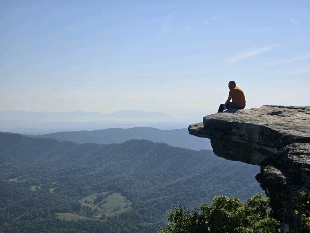
    We reached Mcafee knob about 9:00. This is one of the most photographed places on the entire AT, and for good reason. 

    Chuck at McAfee Knob
    Chuck at McAfee Knob
    Chuck at McAfee Knob
    Chuck at McAfee Knob
    Overkill at McAfee Knob
    Chuck at McAfee Knob
    Overkill and Chuck at McAfee Knob
    Overkill and Chuck at McAfee Knob

    YouTube video of McAfee Knob.

    Roanoke airport from McAfee Knob.

    Roanoke airport from McAfee Knob

    It’s hard to overstate the awe of being on McAfee. It’s spectacular in its own right, but it’s a huge milestone on an AT thru-hike. People have been talking about McAfee since starting in Georgia. We may have take. A few too many pictures, but as you can see it’s worth it!

    We left McAfee at 9:30 and headed to Tinkers Cliffs, the last of the triple crown. Stopped at a slow-flowing spring above Campbell Shelter to top off water at 10:10.

    Campbell Shelter

    Nice views at Tinkers cliffs. Stopped for about 39 minutes and took a break.

    views at Tinkers cliffs
    Chuck at Tinkers cliffs
    Overkill at Tinkers cliffs

    YouTube video from Tinkers Cliffs.

    Stopped at Lambert Shelter for water at 2:30.

    Lambert Shelter

    Had a long, nasty hike all afternoon and evening. Hot, rocky, dry, and not fun. We are nursing our water to get to Daleville. We are both tired and hurting. We will be 3 hours late in Daleville.

    The dam and reservoir above Roanoke.

    dam and reservoir above Roanoke
    Powerlines near Roanoke

    Got to Daleville at 8:05. We are too tired to go out to dinner.

    Welcome to Daleville, VA

    Got checked into the Super 8 and walked across the highway to get frozen burritos, snacks, and breakfast at the mini-mart. Showered, ate, attempted to dry clothes, talked to Dana briefly, and was in bed at 10:30.

    Drying clothes in Daleville
    Dinner in Daleville

    Good start to the day, but the second half was a brutal death march. And tomorrow looks to be more of the same. We need to figure out how to make our days less painful.

    Overkill and I have bonded well over the past week. Between the trail difficulties and the triple crown milestones and other things, we are really helping each other get through the day and make the miles. We talked about it a bit today. I guess we are a tramily of two. 

    Day 69 map – Catawba Shelter to Daleville

    Technical Notes:

    • Pop tarts 370
    • Hershey bar 360
    • Snickers 250
    • Trail mix 210
    • Snickers 250
    • Trail Mix 210
    • Beef stick 90
    • Trail Mix 210
    • Orange crush x4 840
    • Burrito 840
    • Hot pockets 590
    • Pringles 500
    • Water liters 6
    • Miles 17.8
    • Time 12
    • Elevation gain 3789
    • Calories consumed 5000
    • Calories burned 7000
  • Day 68 – VA 620 to Catawba Shelter

    Day 68 – VA 620 to Catawba Shelter

    Today’s Miles: 15.7

    Trip Miles: 720.7

    Up at 6:00. Eric made us bacon and eggs! Got to the trailhead at 7:30. Hot, humid, and clear today. On the trail at 7:50. 

    Carrying 4 days of food and 3 liters of water. Ouch! All the water sources are dry. We have big climbs and plan to road walk to the Catawba market for water around noon. 

    Stopped for a second breakfast at 9:05 and mile 2.6. Done with the first big climb today. 

    Major milestone at 9:30 today…. 700-mile mark.

    700 mile marker

    Nasty climb and hand and knee rock scrambles. Scrambling boulders with your center of gravity all messed up due to an extra 32 lbs on your back is quite challenging.

    Rock scramble near Catawba

    View down onto VA 311 Catawba Road from the ledges.

    VA 311 Catawba Road from the ledges

    Got to Dragon’s Tooth at 11:30. The first of the Virginia triple crown, Dragon’s Tooth, McAfee Knob, and Tinker Cliffs. I’ve been wanting to do the VA triple crown for years. 

    Read about the VA Triple Crown here.

    Some pics on top of Dragon’s Tooth. The rocks are stunning and the views spectacular. I climbed about 3/4 of the way up it before I lost my nerve.

    Dragon’s Tooth

    YouTube video of Dragon’s Tooth from the base.

    Chuck near summit of Dragon’s Tooth

    This picture is looking straight down the cliff. I tried to use my leg in the pic to give perspective.

    Chuck near summit of Dragon’s Tooth
    Chuck near summit of Dragon’s Tooth

    That is the tooth directly behind me.

    Chuck in front of the Tooth

    YouTube video of Dragon’s Tooth from the TOP.

    After exploring Dragon’s Tooth, we had to climb down the front side of it to reach Catawba Road. This was a difficult climb down 80+ degree angle rock faces. Much more difficult with a heavy pack on. This descent took us almost an hour.

    Yes, the climb down literally was vertical at times. Holy crap!

    Vertical descent down from Dragon’s Tooth

    The only way down this part was on your butt. That is Overkill following me down on about an 80-90 degree angle that doesn’t show well in pictures. 

    Vertical descent down from Dragon’s Tooth
    Butt slide down the mountain

    There were a lot more ledges and rock ridges on the way down with great views. Could not resist a picture of Overkill surveying all that is hers.

    Overkill surveying all that is hers

    When we finally finished the descent, we hiked .3 miles on roads to Catawba Market for water at 2:00. This stop is all about water as there is none all day until we reach the shelter at 15.7 miles. Bought two 3-liter bottles of water to fill ourselves up. And had pizza and ice cream and 2 hot dogs and a big Hershey bar as long as we were here. Started walk back to trail at 2:45. We have 8 miles or 4 hours to get to Catawba Shelter.

    Long hot dry afternoon hike including several cow pastures. With all the livestock around, any creeks that are not dry (very few) are NOT GOOD water sources due to fecal contamination.

    Long, hot, dry walk
    We are being watched
    Overkill on death march through hot fields

    Did some more big rock climbs on our way up to camp.

    Rock scrambles
    Rock scrambles

    Finally crossed VA 311 at 6:25. 1 hour and 2 miles to go to reach Catawba Shelter.

    Nearing Catawba Shelter

    Got to Catawba Shelter at 8:00. 3 other people in the shelter with us and there is a tiny water flow in the spring. Had to scoop water from a small pool. It’s so late and we are so exhausted that we both just had a cold dinner and crawled in bed at 9:30.

    The afternoon hike took us 2 hours longer than planned. I don’t understand why we are moving as slowly as we are. Combination of rocks, heat, water, and lack of a break in a while I suppose. 

    Day 68 map – VA 620 to Catawba Shelter

    Technical Notes:

    • Bacon 200
    • Eggs 200
    • Toast 100
    • Trail mix 210
    • Beef stick 220
    • Fritos 200
    • Dr Pepper 240
    • Pizza 400
    • Hot dogs x2 630
    • Snickers 250
    • Gatorade 50
    • Dinner 600
    • Water liters 6
    • Miles 15.7
    • Time 12
    • Elevation gain 3816
    • Calories consumed 3500
    • Calories burned 6500
  • Day 67 – Slackpack VA 630 to VA 620

    Day 67 – Slackpack VA 630 to VA 620

    Today’s Miles: 18.2

    Trip Miles: 705

    Upper 70s, clear, and humid today. Last “cool” day in the forecast for over a week. 

    Up at 5:45. Eric bought us lovely chocolate chip muffins for breakfast. Yum. Had two. Left Eric’s to drive to the trail at 6:40. On trail at 7:30.

    We passed the Keefer Oak. Largest oak on the AT.

    Keefer Oak
    Overkill next to the Keefer Oak
    Keefer Oak

    Walked through several farm fields. 

    Walking through hay fields

    Stopped for second breakfast at 9:30. Making good time now that we are up on the ridge for many miles.

    Up on the ridges

    Traversed a lot of rock ledges with awesome views towards Roanoke about 3 mountain ridges over.

    Rock ledges over Roanoke
    Hazy humid day near Roanoke

    Stopped and talked to a trail maintenance crew weed-wacking and chainsawing. Nice folks.

    Crossed the Eastern Continental Divide. Eric Hanson maintains the next 4 miles of trail from here north. Thanks Eric and all of the Roanoke Appalachian Trail Club.

    Eastern Continental Divide

    Passed a large area of controlled burn. This had to be done this spring based on the smell and the minimal regrowth.

    controlled burn
    controlled burn

    Made it to Niday shelter for lunch at 12:30 and 9 miles. It’s getting a bit warm and more humid out here, but there is a decent breeze. Took shoes off to stretch and rest feet. Got a full load of water and back on trail at 1:30.

    Niday shelter

    Lovely bench in the middle of  nowhere. We took a break here from 4:00 to 4:25. Lovely.

    bench in the middle of  nowhere

    We stopped at the Audie Murphy memorial. Audie was killed near here in a plane crash in 1971.

    Audie Murphy memorial
    Audie Murphy memorial

    We got to the AT crossing at VA 620 at 6:15. Eric pulled up to get us just a few minutes later. Back to Eric’s for a great dinner. Eric and I introduced Overkill to Alice’s Restaurant (the song in its entirety) over dinner. She actually appreciated it.

    Got our gear packed up and ready to go for tomorrow morning. Also made hotel reservations at the Super 8 in Daleville for Friday night.

    Big shout out to Eric for hosting, feeding, and driving us for two days! Thanks, brother!

    Overkill, Kringle, Orange Man

    This was a surprisingly hard day.  Both of us were struggling the last 3 miles. Feet mainly. I would have thought these big days would be easier by now. The amount of water we are carrying isn’t helping, and it’s much more rocky than expected. Still, we are getting it done.

    Day 67 map – Slackpack VA 630 to VA 620

    Technical Notes:

    • Muffins x 2, 1000
    • Trail mix, 210
    • Beef sticks, 200
    • Fritos, 320
    • Snickers, 250
    • Snickers, 250
    • Coke, 150
    • Nut thins, 200
    • Hummus, 100
    • Chicken breast, 600
    • Misc, 350
    • Seltzers, 300
    • Bourbon, 500
    • Fritos, 320
    • Water liters, 5.4
    • Miles, 18.2
    • Time, 10:30
    • Elevation gain, 3686
    • Calories consumed, 5000
    • Calories burned, 6750
  • Day 66 – War Spur shelter to VA 630

    Day 66 – War Spur shelter to VA 630

    Today’s Miles: 9.10

    Trip Miles: 686.8

    Clear day going up to low 80s. Very humid.

    Up at 7:30. No hurry this morning as we have a short day with a nasty 3.5-mile climb to start things off. Yey! On trail at 9:00.

    Walked through a nasty set of blowdowns. All massive trees uprooted. Tornado?

    Tornado?

    Summitted this bastard at 11:30. Mountain is very steep and it’s very humid with zero air movement today.

    Steep and hot and humid

    Stopped for a break at 11:30. Low on water and no more water sources for 4 miles.

    Tripped over a rock and hurt a toe on my right foot. Very steep and rocky descent. I don’t think it’s broken but it has quickly turned a lovely purple and it hurts. Still have 2 more miles of descent.

    Stopped at Laurel Creek Shelter for a break. Water just north of the shelter in theory. Pinged Eric to let him know we are on track to meet at 3:00.

    Stopped for a 10-minute break and snack at 2:10. 2 miles to go.

    Hiked through some nice pastures.

    Pasture hiking
    Pasture hiking

    We reached the VA 630 parking lot st 3:15. Eric met us a few minutes later with ice-cold beverages and iced Snickers. I love my brother! Stopped at a market for resupply on the way to Eric’s house. Eric made us a great dinner. We showered and did laundry and planned out the next 4 days. We will slackpack 18 miles tomorrow and end up about 3 miles down the road from Eric’s house. Then we will impose on Eric for yet another night before heading off to McAfee Knob.

    All my packages arrived at Eric’s house:

    • New Hoka Speed Goats courtesy of Dana 
    • A resupply box courtesy of Dana
    • A new Sawyer water filter. 
    • A new pump sack for my air mattress. 
    • Insoles for my shoes.

    Really looking forward to new shoes and new insoles. Will put them to the test tomorrow with 18 hot, humid miles. 

    Today might have been short miles, but big climbs and very hot and humid. Just can’t wait for July and August heat and humidity in the mid-Atlantic!

    Day 66 map – War Spur shelter to VA 630

    Technical Notes:

    • Donuts: 600
    • Snickers: 250
    • Trail mix: 170 
    • Meat stick: 90
    • Payday: 240
    • Seltzers: 600
    • Cheeseburger x3: 1200
    • Corn on cob: 155
    • Misc: 1000
    • Water liters: 5
    • Miles: 9.1
    • Time: 6:15
    • Elevation gain: 2369
    • Calories consumed: 4500
    • Calories burned: 5000
  • Day 65 – Pine Swamp Branch Shelter to War Spur shelter 

    Day 65 – Pine Swamp Branch Shelter to War Spur shelter 

    Today’s Miles: 12.6

    Trip Miles: 677.7

    Up at 7:30. Slept great. Ate, packed, did morning chores, and on trail at 8:40. Probably doing a short 13 miles today to War Spur shelter and saving big day for tomorrow. Got a 10-mile water carry again today.

    Mid-60s going up to 85 with 35% chance of rain between 3:00 and 5:00. Very, very humid already.

    Crossed a substantial footbridge and got more water at 10:00. Making good time.

    substantial footbridge

    And now it’s time for this thing. Yuck.

    They call this hill The Elevator

    They call this hill The Elevator because it goes straight up. Ugh. This was rough. 

    Made it to Bailey’s Gap shelter at 11:45. Going very slow. It’s very humid and steep. Took a long break and ate. 2.5 miles to water….we hope. Headed back on trail at 12:15.

    Bailey’s Gap shelter

    Stopped for water at 2:00. Slow trickle of water, but it works. Hard day. We have been out here 5 hours and only made 6.7 miles. Rocky, hot, humid, steep. Hoping the next 6.5 miles are a bit faster.

    Crossed Mountain Lake Road .2 miles south of Windrock. This is bringing back memories of the later 80’s. How many times have I driven this road…sometimes in the pitch black? Road is in better shape than it used to be.

    Mountain Lake Road

    Last time I was at Windrock was 1990. Jon Luning and I drove up here one Sunday morning after a Saturday party at 448 East Roanoke. Our goal was to watch sunrise. 

    Windrock
    Chuck at Windrock

    Got to War Spur shelter about 6:00. Rained on us from 5:15 until we got to camp. One older couple is tenting here and I have 2 bars of cell service.

    War Spur shelter

    Good water near the shelter. We ate dinner, made a plan for tomorrow. And set up a time for Eric Hanson to pick us up tomorrow afternoon. Really looking forward to seeing Eric and swapping trail stories. Looks like we will spend the next 2 nights with him while we hike the days near his house. 

    Got settled into bed in the shelter, talked to Dana for a bit, and tried to sleep at 9:30.

    Day 65 map – Pine Swamp Branch Shelter to War Spur shelter

    Technical Notes:

    • Donuts: 600
    • Trail Mix: 270
    • Trail Mix: 400
    • Snickers: 440
    • Beef Sticks: 90
    • Dehydrated Chicken: 170
    • Ramen: 740
    • Quest Cookies: 220
    • Water Liters: 6
    • Miles: 12.7
    • Time: 9:20
    • Elevation Gain: 2538
    • Calories Consumed: 3000
    • Calories Burned: 4500
  • Day 64 – Pearisburg Cemetery to Pine Swamp Branch Shelter

    Day 64 – Pearisburg Cemetery to Pine Swamp Branch Shelter

    Today’s Miles: 19.7

    Trip Miles: 665.1

    Up at 7:00. Finished packing and ready to go at 7:30. Waiting on the shuttle. It is 64 degrees going up to 85. Clear and nice so far. Got on the trail just after 8:00.

    Pack is heavy with 4 days of food and an extra liter of water! Gonna be very dry today again.

    Leaving Pearisburg and crossing the New River at 8:15.

    Leaving Pearisburg and crossing the New River
    Leaving Pearisburg and crossing the New River

    Reached Landfill Road just outside town. Lots of warnings about the water here. Go figure.

    Water warnings at Landfill Road

    Going up the mountain next to the landfill, we ran into a bear. He just crested a hill we were heading up, and he was walking on the trail. I stopped. He stopped. We stared at each other for a second. He turned around and scampered off back down the trail. 

    Stopped for a quick break at 10:30.

    Summited Peter’s Mountain. Big meadow with awesome views to Petersburg, West Virginia.

    YouTube video of the view to WV

    Stopped at Rice Field Shelter at 11:45 at mile 7.1. Rested my feet and back and had a second breakfast. Very nice shelter. There was a family from town having a picnic at the shelter. No water though. Headed out again at 2:15.

    Only water for most of the day at mile 8. Nothing else for the next 11 miles.

    Snack at 2:15 at 10.1 miles.

    Crossed through some pipeline construction.

    pipeline construction

    We are hiking on a ridge right on the WV border.  In and out of WV all afternoon.

    Welcome to WV

    Leapfrogged with Tortilla several times.

    Hit one terminus of the Allegheny Trail. This 300-mile trail is on my to-do list.

    Terminus of the Allegheny Trail

    Got to Pine Swamp Branch Shelter at 7:30. Tough last 2 miles. Very rocky. Tortilla stopped by to have dinner, then headed on to the next shelter about 3 miles away.

    Got settled into the shelter (just me and Overkill), set up bear hang, got water, hung up clothes to dry inside the shelter, and made dinner by 8:30. No cell. Nice shelter inside and out.

    Overkill at Pine Swamp Branch Shelter

    In bed at 9:30.

    Good to do big miles today. Felt good till the last 3 miles. Back and feet hurt. New shoes and insoles in 2 days!

    Day 64 map – Pearisburg Cemetery to Pine Swamp Branch Shelter

    Technical Notes:

    • Little Debbies 300
    • Donuts 220
    • Trail mix 170
    • Snickers 250
    • Trail mix 200
    • Payday 250
    • Trail mix 100
    • Trail mix 270
    • Slim Jim 120
    • Backpackers Pantry Lasagna 620
    • Quest chocolate chip cookie 220
    • Donuts 150
    • Water liters 5.4
    • Miles 19.6
    • Time 11:30
    • Elevation gain 4337
    • Calories consumed 3200
    • Calories burned 7500
  • Day 63 – Slackpack Sugar Run Road to Pearisburg Cemetery 

    Day 63 – Slackpack Sugar Run Road to Pearisburg Cemetery 

    Today’s Miles: 11.6

    Trip Miles: 645.4

    Up at 6:45. Got coffee and some Little Debbies. Enough  Pop-Tarts for a few days.

    Mid-70s, clear, and humid. Going up to low 80s this afternoon.

    We are slackpacking today to finish up the 11.6-mile section northbound into Pearisburg. This gives us a good 19-miler tomorrow out of Pearisburg to either a shelter or a tent site on Peter’s Mountain. 

    I got the shuttle to the trail with Overkill at 7:30. Drove to Sugar Run Road where we got off trail 2 days ago. Started hiking at 8:00.

    Got some great views from the power lines.

    Power lines over Pearisburg
    Power lines over Pearisburg
    Power lines over Pearisburg

    This is looking down at Narrows VA and the New River.

    Narrows VA and the New River

    Took a break at Pearis Ledges for an excellent view of the valley.

    Pearis Ledges

    YouTube Video from Pearis Ledges.

    Great view of Pearisburg and 460 crossing the New River from Angels Rest. 

    Pearisburg and 460 crossing the New River from Angels Rest
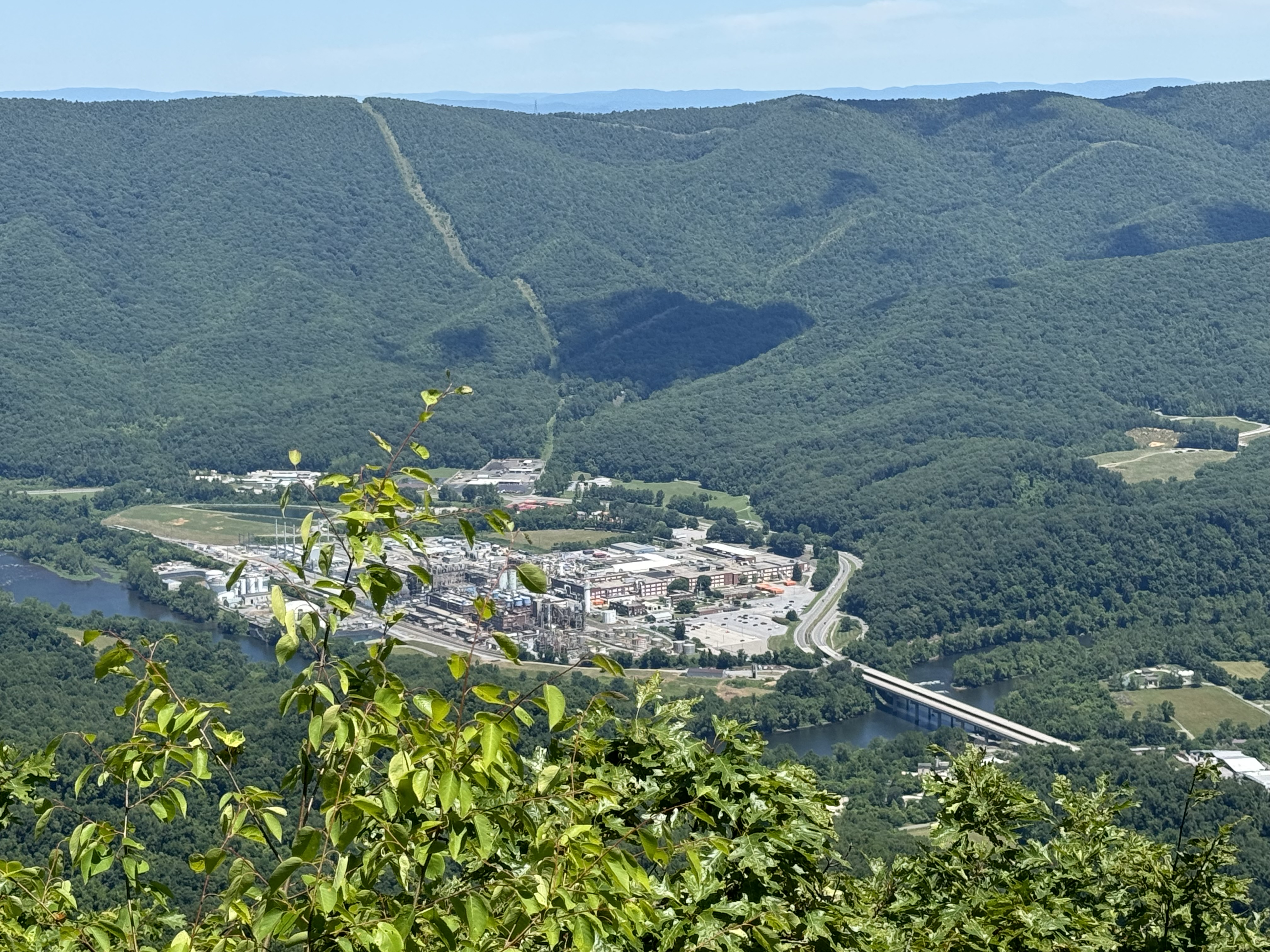
    Factory on the New River

    YouTube Video from Angels Rest.

    Finished at the old Pearisburg Cemetery at 2:00 and shuttled back to the hostel. 

    Grabbed a shower, updated some blogs, and walked into town with Overkill at 4:00. She had some gear shopping to do, and I’m going to Dairy Queen for a couple of cheeseburgers !

    Overkill and I plan to get a shuttle to the trail at 7:30 tomorrow. The first 5.7 miles is a climb and would like to knock that out by 11:00ish.

    Schedule Update

    After today, we have a 4-day hike to Dragon’s Tooth and the Virginia Triple Crown. We will stay with my friend Eric on the third or fourth night. I also have several packages going to his house. Which night we stay with him is his call. I’ll reach out to him later tonight. He is just getting back from a week-long AT section home in NJ today. 

    After that, it’s 2 days to Daleville, VA, just above Roanoke. Then we have a 9- or 10-mile hike to Waynesboro, where we will enter Shenandoah National Park. We will spend about 7 days in the Shennies, then 3 or 4 days to Harper’s Ferry! That’s three big milestones: VA Triple Crown, Shenandoah, and Harper’s Ferry. 

    We are getting close to the halfway point.

    Day 63 map – Slackpack Sugar Run Road to Pearisburg Cemetery

    Technical Notes:

    • Little Debbies 650
    • Snickers 250
    • Snickers 250
    • Little Debbies 150
    • DQ Double cheeseburger x 2 1200
    • DQ fries 450
    • DQ onion rings 290
    • Beverages 1500
    • Pringles 1050
    • Water liters 2.5
    • Miles 11.6
    • Time 6:00
    • Elevation gain 2563
    • Calories consumed 5800
    • Calories burned 4500
  • Day 62 -Zero in Pearisburg, VA

    Day 62 -Zero in Pearisburg, VA

    Today’s Miles: 0

    Trip Miles: 633.8

    Up at 8:00.  Made coffee and relaxed.

    Uploaded blogs most of the day.

    Tried to find decent insoles and failed.

    Updated schedule through Shenandoah.

    Did town chores and patched the hole in my CNOC.

    Got my slackpack packed and ready for tomorrow. We depart at 7:30. Dry stretch of trail, so I’m taking an extra liter of water.

    Overkill, and I had decent Mexican for dinner at 6:30. We talked over our plans in more detail, including mileage goals, mountains, and water issues. I did my resupply shopping at Kroger after dinner and talked to Dana. Nice evening overall.

    Back to the hostel and packed up my food bag for next week. Carrying 4.5 days of food, that is 1 more than I should need, but it is all lightweight, and I like a buffer. Plus, I’m starting to eat a lot more, even though I’m losing weight. I’m getting better about cutting out the excess. 

    Speaking of weight…. I am down to 195 lbs. At some point, I will need to start changing my diet to STOP losing weight. I will start to burn muscle if I haven’t already. I need to start getting more protein and more fat in my diet soon.

    My feet and back feel a lot better today. Glad we took the day off. Really looking forward to new shoes and new insoles next week. Gotta start doing 18+ mile days consistently very soon.

    Finished the last few days of blogs and watched YouTube till about midnight. Gotta be up by 6:30.

    Technical Notes:

    • Not tracking food today. 
    • Water liters 
    • Miles 
    • Time 
    • Elevation gain 
    • Calories consumed 
    • Calories burned 
  • Day 61 – Dismal Creek to Sugar Run Road

    Day 61 – Dismal Creek to Sugar Run Road

    Today’s Miles: 9.7

    Trip Miles: 633.8

    Up at 7:00. Out at 8:10. Hot and humid.

    Stopped at Wapiti shelter at 9:00 for privy, water, and a snack. Back on the trail at 9:30.

    Wapiti shelter

    Now for a big 2.4-mile, fairly steep climb. Yey.

    Completed the nasty climb at 11:00. It is really humid today. I am soaked in sweat all over, and it’s only early June . Ugh. 

    We have 2.5 hours to go. 4.8 miles to our shuttle. Easy terrain. Headed out at 11:30 after a snack and water break. No good scenery. Hazy and lots of vegetation.

    Hazy and lots of vegetation

    Got to Sugar Run Road at 1:45. Very rocky last 1.5 miles. Shuttle pulled up as we got there. Nice shuttle ride to Angel’s Rest Hostel in Pearisburg, VA. Here is a map so people understand where we are.

    Pearisburg – Blacksburg – Roanoke map

    Overkill and I got checked in. I got a single room as usual.  Nice place. I showered, did laundry, ordered a new Sawyer filter and a new pump sack for my air mattress, called Dana, and started planning out the next two weeks. 

    We have a bit of a quandary for our next day. Where we will be on the trail is 20+ miles to the next camping spot, and that includes a big 5.5-mile uphill out of Pearisburg to end that day. We need to decide if that is reasonable or not before planning out anything else.

    Overkill and I went to AYCE Chinese for dinner, then to Kroger for snacks and breakfast food. Back to the hostel by 6:30.

    We did decide to slackpack 11.5 miles from where we got off trail back to the hostel on Saturday.  Should make for a mellow day. We also agreed on a schedule from now to Waynesboro at the start of Shenandoah.

    I touched base with Eric Hanson. We will be in his area on Tuesday or Wednesday. Will work details with him on Saturday or Sunday. Either day works for us. 

    We also decided we WILL stop in Glasgow, VA and hitchhike into town. That’s the last place to resupply for 4-5 days before reaching Shenandoah. 

    I’m exhausted! Fell asleep watching YouTube by 8:00.

    Day 61 map – Dismal Creek to Sugar Run Road

    Technical Notes:

    • Pop-Tarts 370
    • Trail mix 200
    • Snickers 250
    • Trail mix 300
    • Beef sticks 90
    • Chinese 2000
    • Seltzers 300
    • Snacks 1000
    • Water liters 5
    • Miles 9.5
    • Time 6
    • Elevation gain 2000
    • Calories consumed 4500
    • Calories burned 4000
  • Day 60 – Tent Site at Mile 599.3 to Dismal Creek

    Day 60 – Tent Site at Mile 599.3 to Dismal Creek

    Today’s Miles: 17

    Trip Miles: 624.3

    Up at 7:00 and on the trail at 8:00. Mid-70s, partly cloudy, and humid today.

    We passed the 600-mile mark just after leaving camp. Another minor milestone.

    600 mile marker

    Made Jenny Knob shelter at 4.6 miles at 9:55. Good time! Had a rest and a snack. Struggled to get water. Very minimal flow, but this is it for miles in each direction. Had to scoop water from little pools in the creek bed. Scooped a little swimming critter into my CNOC. He won’t drink much 🙂

    Back on the trail at 11:00.

    Crossed Kimberling Creek at 2:25. Interesting suspension bridge. It sways a lot.

    Kimberling Creek suspension bridge

    Got to Dismal Falls at 3:30. Amazing place. Cold water! Soaked my feet for a while. This may be the coolest place yet on the AT. 

    Dismal Falls
    Dismal Falls
    Overkill at Dismal Falls
    Orange Man at Dismal Falls

    YouTube video of Dismal Falls.

    Got a full load of water as it’s unclear how good the water is for the next 5 miles to camp. Headed out at 4:15.

    Would not be a week without a snake. He’s about 6 feet long.

    Big Black Snake

    Got to Dismal Creek at 6:15 and found 2 decent tent sites. Set up camp and made dinner by 7:25.  It’s humid and no breeze down by this creek, unfortunately. Doubt the clothes will dry much, but we’ll give it a try.

    campsite by Dismal Creek

    In bed at 8:00. Texted with Dana and tried to sleep at 9:30.

    Short 9.5 miles to a road so we can get a shuttle at 2:00 into Pearisburg. All you can eat Chinese!!!

    Day 60 map – Tent Site at Mile 599.3 to Dismal Creek

    Technical Notes:

    • Pop-Tarts 370
    • Trail mix 370
    • Beef sticks 90
    • Snickers 250
    • Trail mix 370
    • Snickers 250
    • Fritos 400
    • Dehydrated pork 120
    • Knorr rice dish 290
    • Fritos 300
    • Pop-Tarts 370
    • Water liters 6
    • Miles 17
    • Time 8:30
    • Elevation gain 2873
    • Calories consumed 3300
    • Calories burned 6000