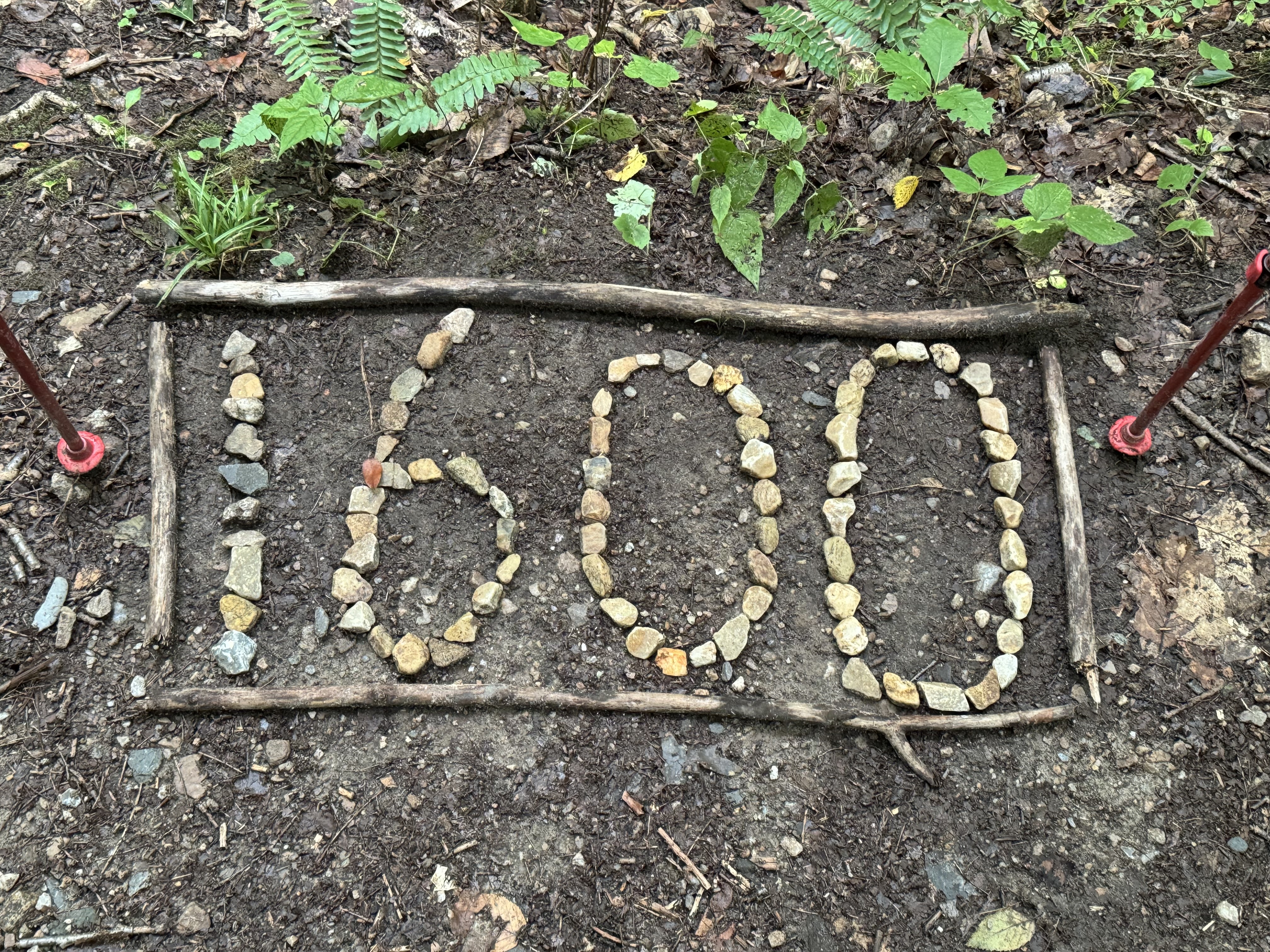
Tag: Vermont

  • Day 131 – Goddard Shelter to Kelly Strand Road

    Day 131 – Goddard Shelter to Kelly Strand Road

    Today’s Miles: 12.5

    Trip Miles: 1648.6

    “Well, it was Gatlinburg in mid-July

    And I just hit town and my throat was dry

    Thought I’d stop and have myself a brew

    At an old saloon on a street of mud

    There at a table, dealing stud

    Sat the dirty, mangy dog that named me Sue” – Johnny Cash

    Up at 7:30. Cold damp and windy. I only have 12.5 miles to the road where I’m getting picked up at 4:00. About 7 hour hike so not leaving until 9:00. 

    Got on trail at 9:15. It’s still mid 40s, windy, wet. Starting off in long pants and my rain jacket for warmth. Not a fun morning.

    Stopped for a snack at 11:30 and 4.3 miles at Kid Gore shelter. Topped off water. Sticking with long pants as there is a good chance of rain and it will be very cold when that happens. 

    Kid Gore shelter

    Vermud continues to live up to its reputation.

    Vermud continues

    Passed by a large beaver dam and pond. Beaver lodge is just past the dam.

    Beaver dam and lodge in VT

    Got to Story Spring shelter at 2:35. Got 1.6 miles to the road for pickup at 4:00. I’ll kill a little time here. 

    Got to the road at 3:50. Ride should be here soon. One of the women I’ve been hiking around the last two days heard me talk about the Wicked Waystation and decided to go there tonight as well.

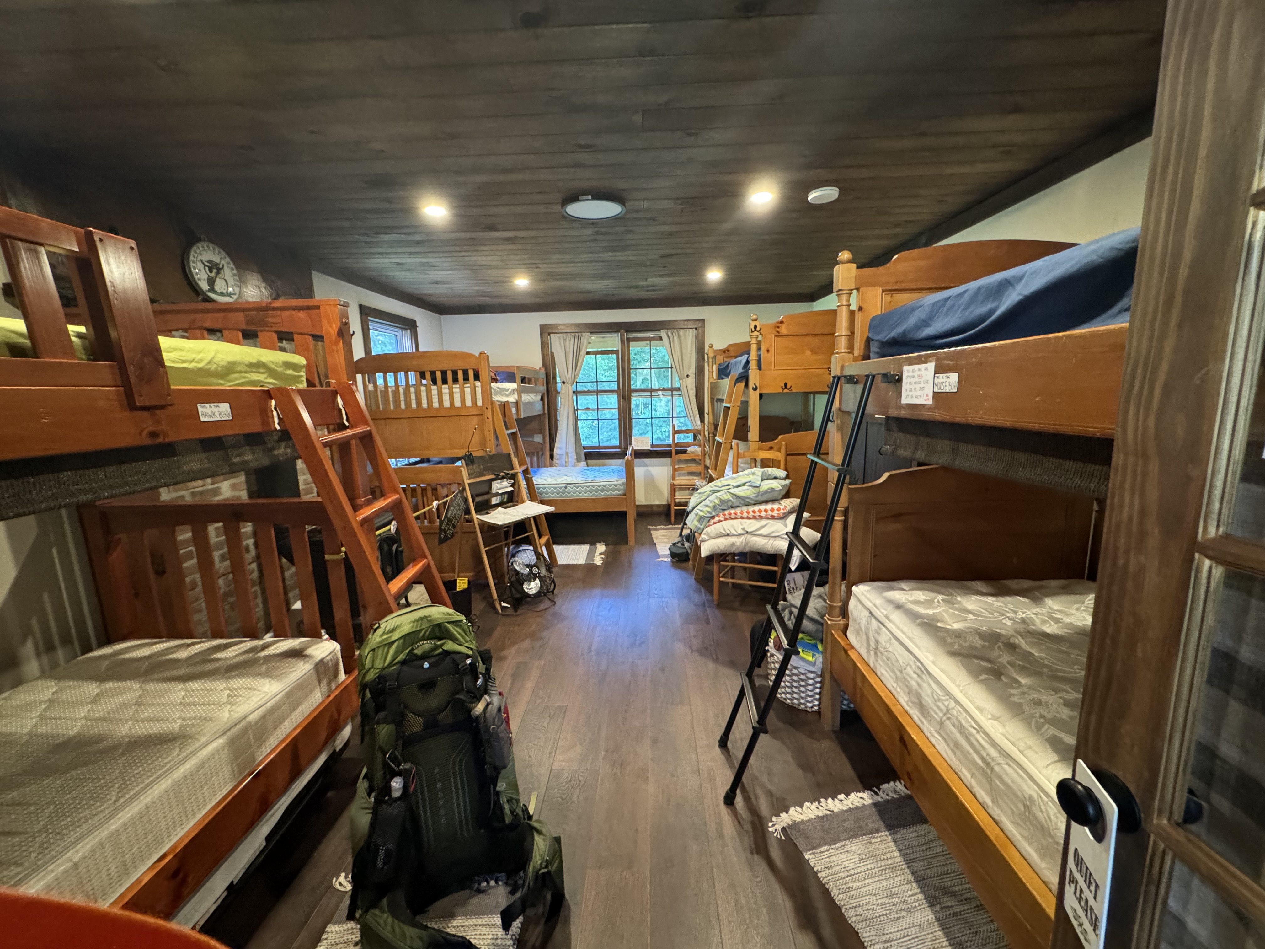
    The Wicked Waystation is amazing. Best hostel I have stayed at so far. Great building, great people, and the store just down the road has an amazing selection for such a tiny town.

    Wicked Waystation
    Wicked Waystation

    We walked .3 miles to the country store and got dinner and I got 4 days of food. We picked up hamburger patties and I cooked dinner for us. Used place mats and everything! It was very nice.

    Researched my plans for tomorrow and the next few days. Did laundry andoshoweredd dried outoutoes. Yey!

    Legend showed up around 8:00. It Good see him again. 

    I tTalked Dana and walked her through all the winter gear I need. She is shipping it tomorrow to the innInnm staying at Tuesday night.  I wWorked more route and lodging planning. I wInd at 10:30.

    Day 131 Map – Goddard Shelter to Kelly Strand Road

    Technical Notes:

    • Pop tart 370
    • Fritos 200
    • Fig bar 250
    • Payday 450
    • Skittles 225
    • Zero sugar sausage 240
    • Hotdog 315
    • Pringles 900
    • Burger 550
    • Burger 550
    • Mashed potPotatoes0
    • Root beer 320
    • Seltzer 420
    • Water 1.4
    • Miles 12.5
    • Time 7
    • Elevation gain 1715
    • Calories consumed 5500
    • Calories burned 5500
  • Day 130 – Congdon Shelter to Goddard Shelter 

    Day 130 – Congdon Shelter to Goddard Shelter 

    Today’s Miles: 14.4

    Trip Miles: 1636.1

    “Cause it’s a good night

    To be out there soaking up the moonlight

    Stake out a little piece of shoreline

    I’ve got the perfect place in mind.

    It’s in the middle of nowhere, only one way to get there

    You got to get a little mud on the tires.” – Brad Paisley 

    Up at 8:20. All 6 of us in the shelter just got moving. Shocked it’s that late. Slept poorly due to damp and cold. 

    High of 56, cloudy, 60% chance of rain.

    I have 14.4 miles to the next shelter. Two of the people from last night are aiming for that same shelter. Hiking a couple of hours with Legend this morning. 

    Bennington VT in the foreground  with NY in the middle distance . Looking west.

    Bennington VT in the foreground with NY in the middle distance

    The trail mileage on that sign is dated. It’s actually 5l80.8 from here.

    Trail Mileage sign in VT

    Got to Route 9 at 12:10. Legend is going into Bennington from here and I’m going on to a shelter. The road is at the bottom of a super steep V. Super rocky down to here. Hopefully the other side of the V going up is not rocky.

    Orange Man and Ledgend near Bennington, VT

    Back on trail at 12:45.

    Passed THROUGH Split Rock.

    Split Rock

    Entered the Glastenbury Wilderness at 2:10. Also got a view of the rain to the west that’s headed my way soon. Bummer. Got 7.9 miles to shelter. Don’t think I’ll beat the rain. 

    Another afternoon of this.

    Mud in the Glastenbury Wilderness

    Got to shelter at 6:15. It’s getting cold. Three women in shelter with me, including Uno. Ate, put on all my clothes (two layers, top and bottom), including 2 pairs of socks and gloves. Need my winter gloves and other gear. In my quilt at 8:00. Really need my cold weather quilt! It’s going to be low 40s and rainy tonight. Again!

    Day 130 Map – Congdon Shelter to Goddard Shelter

    Technical Notes:

    • Mini donuts 560
    • Pop tart 370
    • Zero sugar sausage 120
    • Zero sugar sausage 120
    • Skittles 100
    • Cheese crackers 250
    • Fig bar 200
    • Skittles 100
    • Ramen 740
    • Dehydrated chicken 170
    • Fritos 600
    • Water 2.1
    • Miles 14.4
    • Time 8:30
    • Elevation gain 3971
    • Calories consumed 3500
    • Calories burned 7000
  • Day 129 – Williamstown, MA to Congdon Shelter

    Day 129 – Williamstown, MA to Congdon Shelter

    Today’s Miles: 14

    Trip Miles: 1621.7

    “We got “Whiskey River” on a jukebox

    A honky-tonk sawdust dance floor

    A neon, five o’clock, broke clock

    And plenty damn many when you want one more

    Of this broke heart fool on an old bar stool

    Drinkin’ beer almost as cold as you

    Cold as you” – Luke Combs

    Up at 7:30. Drizzle and chilly. Shuttled to trail at 8:30 by motel owner and on trail at 8:45. 14 miles to go today and weather is supposed to get better around 11:00 a.m.

    Partly sunny, low 50s going to up to mid 50s. Scattered showers.

    1600 Mile Marker

    AT 10:00 I had a nasty rock scramble up into the clouds. Slippery rocks. Not fun.

    Rock scramble in the rain

    11:10 crossed into Vermont. Vermont being Vermud, that was as close as I could get to the sign without being ankle-deep in mud. I’m balancing on a half-submerged log.

    Welcome to Vermont

    This is what the trail was like all afternoon in Vermud. 

    Vermud
    Vermud

    Stopped at Seth Warner Shelter at 2:30 and 9.3 miles in for a snack. Slow going this afternoon due to all the mud. Got 4.8 miles to my destination for the night. Should be there about 5:30. Met another Long Trail NOBO at the shelter. That makes two for today who are both headed to the same shelter as me for the night. Back on trail at 2:50.

    The temps coupled with the wind and wet make for a very chilly afternoon. Low tonight is 45 with more rain. I feel like I’m back in the Smoky Mountains. Glad I got some of my cold weather gear back last week. Need to get the rest back soon. And it’s only August 20!

    Got to Congdon Shelter at 5:15. Made really good time. There are 5 other people and a dog here tonight. Three are AT NOBO and two are hiking The Long Trail. 

    Ate dinner by 6:30, made my bear hang,  and put on all my layers of clothes. It’s damp and going down to low 40s. I need to get the rest of my cold weather gear ASAP, including my 20-degree quilt. I’ll be climbing into bed by 8:00 just for warmth.

    Day 129 Map – Williamstown, MA to Congdon Shelter

    Technical Notes:

    • Everything bagel 280
    • Apple juice 120
    • Coffee 20
    • Zero-sugar sausage 120
    • Fig bar 200
    • Zero-sugar sausage 120
    • Zero-sugar sausage 120
    • Skittles 250
    • Cookies 200
    • Ramen 740
    • Dehydrated chicken 170
    • Cookies 400
    • Water .5
    • Miles 14
    • Time 8:30
    • Elevation gain 3677
    • Calories consumed 3000
    • Calories burned 6000