Category: AT Thru-Hike 2024

  • AT Thru-Hike 2024 – Epilogue 

    AT Thru-Hike 2024 – Epilogue 

    “… Sometimes the light’s all shining on me

    Other times I can barely see

    Lately it occurs to me

    What a long, strange trip it’s been” – Grateful Dead
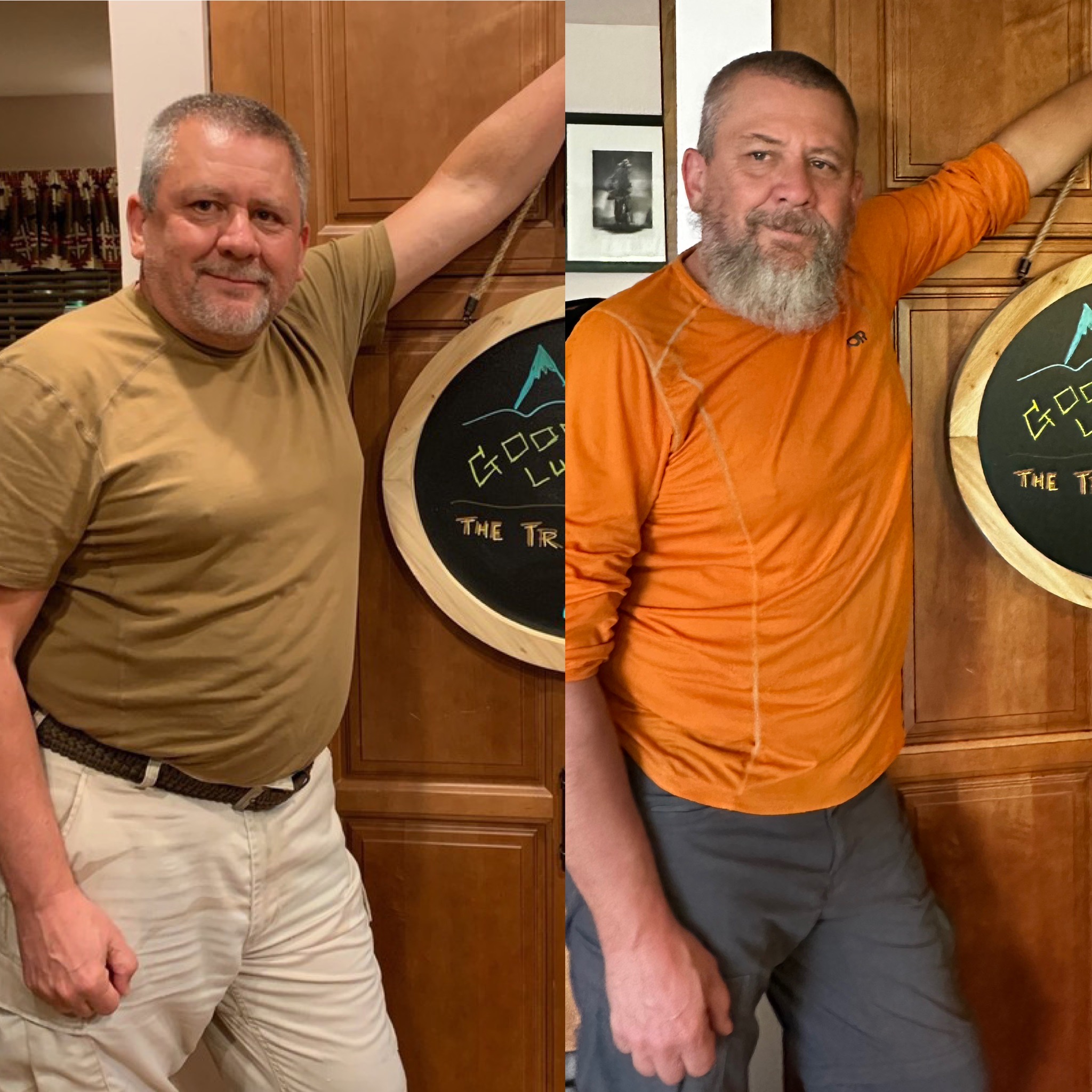
    Before and After

    Before and after

    I waited 10 months before finally writing up this epilogue. It took me that long to really get a handle on my thoughts and my emotions. I still feel depressed and miss the trail at times. Not sure if/when those feelings will ever go away. 

    I can attest that post-thru-hike depression is a real thing. The first 2-3 days home felt strange but not too much different from taking a double zero. But it quickly became apparent that I was back in civilization and that the greatest experience of my life was over. And that I would probably never be able to get those feelings back. 

    I did almost nothing but eat for the first month back home. And think back on the past 6 months on trail. It is almost impossible to explain these feelings to somebody who has not had a similar experience. There is a longing for the people, the places, the experiences, and the total freedom that came with it. Suddenly you are back in civilization and time, hours and days and weeks, have more meaning again. Instead of days and weeks being wake, eat, pack, hike, camp, eat, sleep at 8:30 p.m., repeat….the days are now structured. Wake up, take care of the kids, take care of today’s errands/chores, make dinner, watch TV, try to sleep and make sure to get to sleep by 1:00 a.m. The weeks are punctuated by events like putting out the trash, putting out the recycling, shopping for groceries, washing the dishes, doing laundry, cleaning the house, paying the bills, repeating. There is no more adventure and excitement wondering what challenge you will encounter today or what amazing views you will have. As I said, post-trail depression is a real thing.

    Some things that I found strange and took me a little while to get used to:

    • Driving again
    • Shaving 
    • Same clothes (2 shirts, one pair of pants) for 6 months 
    • Checking email 
    • Not walking every day
    • Not looking at the Far Out app 50 times a day to check my location and progress and to plan the next day.
    • Not worrying about how much my food and water weigh. 

    I don’t have many regrets from my thru-hike experience, but there are a few. I originally wanted to be away from people. What I realized later in my hike was that I should have started a few weeks earlier. The last 2 months of the hike were too lonely even for me. It would have been good to have more people around. I also regret not having a larger, more robust trail family the entire trip. I had wonderful times being with the people that I met, but those times were too few or too short.

    The big things that I learned on this thru-hike include:

    • Relationships are very important. 
    • Anxiety sucks. 
    • There is strength in numbers. 
    • You never really know what you can do physically and emotionally until you push yourself to the limit.
    • That which does not kill us makes us stronger. 

    A few items for context:

    • Left Poolesville on April 12 and drove to Amicalola Falls, Georgia.
    • Day 1 of my hike started with the Approach Trail on April 14, 2024. 
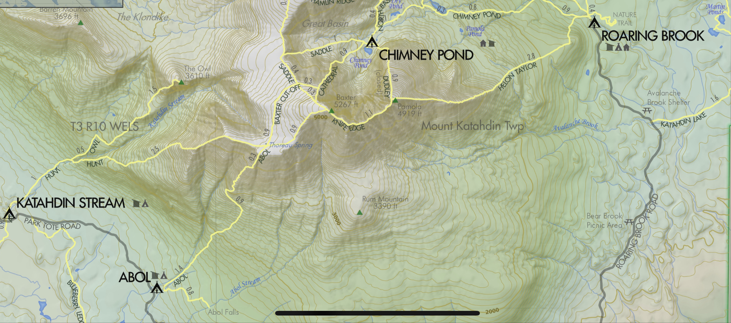
    • I hiked over 2100 miles through 14 states from Georgia to Maine.
    • Elevation gain and loss of 464,464 ft., or more than 89 miles. Equivalent to hiking Mt. Everest from sea level and back 16 times.
    • Day 176 of my hike ended on Mount Katahdin in Maine on October 6, 2024.
    • Flew from Bangor, Maine back to Maryland on October 7, 2024.

    My current plans are to take a break for a few months, then start getting back in shape so that I can do a LASH on the AT from Harper’s Ferry to Roanoke with my friend Ed in the spring and thru-hike the Colorado Trail next fall. I plan to thru-hike the PCT in 2026.

    Chuck at the AT Arch Amicalola Falls
    Orange Man on the Katahdin Sign
    2024 AT Hang Tag

  • Day 177 – Summit Day +1

    Day 177 – Summit Day +1

    Today’s Miles: 0

    Trip Miles: 2101.5

    “Homeward bound

    I wish I was

    Homeward bound

    Home where my thought’s escapin’

    Home where my music’s playin’

    Home where my love lies waitin’

    Silently for me” – Simon & Garfunkel

    Up at 7:30. Packed up and got my backpack into the duffel bag Dana sent me. Shuttled to the airport at 8:45.

    Duffle bag for the flight home

    Drove from Millinocket to Bangor. I-95 in northern Maine is just a bit less busy than in the mid-Atlantic!

    I-95 heading from Millinocket to Bangor

    Got to Bangor International airport at 10:00. Nice little airport. Got checked in and had breakfast before heading through security.

    Had a nice text conversation with Mike, my hiking partner from early on in GA and NC. He saw my facebook post about summiting yesterday

    Had a couple hours at the airport to wait for my flight. Wrote up yesterday’s Summit blog entry. 

    Flew over the Francis Scott Key bridge and got a great view of the missing bridge section from the plane.

    Collapsed Francis Scott Key Bridge on flight home

    It felt so strange walking through Regan airport. All this civilization!! This was my last walking part of my AT adventure. Very mixed emotions.

    Landed at Regan National

    Dana met me at baggage claim and we just stood there and hugged for what felt like an hour. The drive home was very strange. I had not been in a a big town or seen this many people or buildings in six months. 

    And it was still green in Maryland. I just came from the land of vibrant fall colors and leaves dropping off trees. 

    The dogs were happy to see me, sort of. Pen was very excited and hyper. Sky was not sure what to think. She just looked at me and tentatively said hi.

    It is good to be home. I cant believe I have been away for HALF A YEAR. 

    Now I need to figure out how to reintegrate myself into normal life. 

    Home in Poolesville, MD.
  • Day 176 – Summit Mount Katahdin 

    Day 176 – Summit Mount Katahdin 

    Today’s Miles: 9

    Trip Miles: 2101.5

    “I’ve paid my dues

    Time after time

    I’ve done my sentence

    But committed no crime

    And bad mistakes

    I’ve made a few

    I’ve had my share of sand

    Kicked in my face

    But I’ve come through

    And we mean to go on and on and on and on

    We are the champions, my friends

    And we’ll keep on fighting till the end

    We are the champions

    We are the champions

    No time for losers

    ‘Cause we are the champions of the World” – Queen

    Up at 4:00 a.m. Shuttled to Baxter Park entrance at 5:30. Huge line to get in. Tons of people without passes attempt to get in. At 7:00, anybody who has not shown up that had a reservation forfeits their reservation. Everyone gets a chance at the forfeits one at a time.

    Today the line is particularly long due to bad weather yesterday and more bad weather after today. We got in the park gate at 7:00 to drop off only and not park. That was not a guarantee.

    I had a backup plan that would have me    hike in from Abol Bridge and then hike 5 miles up Blueberry Ledge Trail to get to the start of the Hunt Trail. Would have made a long day, but it was a guaranteed plan. 

    Foggy, mid-40s at base, not getting above 41 at the summit. 

    We arrived at Katahdin Stream Campground at 7:10. Got registered with Ranger Don and headed out on trail at 7:25.

    Ranger Station at Katahdin Stream Campground
    Orange Man’s Katahdin Registration
    Welcome to Katahdin Stream
    Hunt Trail to Katahdin Summit

    YouTube video starting up Katahdin 

    Very, very hard ascent. First 3 miles are below tree line and gradually get very steep near tree line. About 2 miles of  incredibly steep nearly technical climbing from tree line onward. Crossed into the fog and clouds a little before ascending above tree line. Then a long ridge walk sloping upward to the summit of Katahdin.

    YouTube video ascending Katahdin 

    Steep rocky trail below treeline on Katahdin
    Moving above treeline on Katahdin
    Technical climb near summit of Katahdin
    Technical climb near summit of Katahdin
    Very difficult and dangerous climb up Katahdin
    Technical climb near summit of Katahdin

    I reached the summit of Katahdin about noon. There were a lot of people summiting today. One decent weather day sandwiched between rain days. It was very windy and cold. The sun was slowly trying to burn through, but not being very successful.

    YouTube video at Katahdin summit 

    Reached the summit of Katahdin

    Polar and 23 were already on the summit when I got there, and the cousins, Newt and Glass, arrived about 5 minutes after me. The official summit is the big rock cairn. 

    Polar, 23, Newt and Glass at the summit of Katahdin
    Orange Man at the summit of Katahdin

    We waited our turn to get our pictures taken at the famous Katahdin sign.

    Newt and 23

    Newt and 23 on the Katahdin Sign

    Newt

    Newt on the Katahdin Sign

    Glass 

    Glass on the Katahdin Sign

    The Cousins Newt and Glass 

    Cousins Newt and Glass on the Katahdin Sign

    Polar

    Polar on the Katahdin Sign

    Me and The Rascals (Polar, Newt, 23, Glass)

    Polar, Newt, 23, Glass, Orange Man on the Katahdin Sign

    As we descended the long steep ridge from the summit to The Gateway, the sun finally came out and we got some good views.

    Above the clouds on the Kathadin descent
    Above the clouds on the Kathadin descent
    Above the clouds on the Kathadin descent
    Orange Man on the Katahdin Descent
    Above the clouds on the Kathadin descent
    Above the clouds on the Kathadin descent
    Steep difficutl descent of Katahdin
    Orange Man on the Katahdin Descent

    Getting down the mountain was also very hard. Very hard descent: 1.5 miles of super steep butt sliding and rock scrambling. Fell a couple of times. 

    Still another 2 miles of hiking after the nasty part back to the ranger station and parking area. 

    YouTube video descending Katahdin 

    Steep difficutl descent of Katahdin

    Finished the descent at 3:45. Met up with 23, Polar, Glass, Newt, and Polar’s parents at a picnic shelter and celebrated with candy bars and champagne!

    Shuttled back to the hostel and had dinner. Then walked down to the saloon to have a few celebratory drinks with some of the other folks who summited today.

    Celebrating our summit day at the saloon in Millinocket

    Today was the hardest day on the trail. Harder than Lehigh Gap and harder than Mahoosuc Notch. If you slip on either the ascent or descent, you are going to get hurt very badly. That was scary and exhilarating all at once. 

    None of the emotions or mental retrospection or regrets have hit me yet. I’m surprised about that. I’m sure it will all hit me tomorrow. 

    I can’t describe how happy I was to summit with The Rascals. All the alone time in New England really gnawed on me. More on that in my upcoming Epilogue post.

    Now I just have one more piece of this adventure. Getting home!

  • Day 175 – Zero – Rainy Day in Millinocket, Maine

    Day 175 – Zero – Rainy Day in Millinocket, Maine

    Today’s Miles: 0

    Trip Miles: 2092.5

    Rainy, cloudy, dreary day as forecast. Slept in. Uploaded blogs up to yesterday.

    Heard from Polar. The Rascals are also in Millinocket due to weather and summiting Katahdin tomorrow. Hopefully, I meet up with them on the trail. Very cool.

    Dana FedExed me a duffle bag I had at home. I will put my backpack and trekking poles in it for the plane trip home.

    Confirmed my flight for Monday and a shuttle ride from the hostel to Bangor at 9:00 a.m. Monday. I’m all set!

    Went to Scootic In Restaurant for dinner  again at 6:00. Not really many choices. I need to be up at 5:00 a.m. I doubt I’ll be able to get to sleep until well after midnight. Oh well.

    Ran into Shaggy and his dad, whose name I forget. Have not seen them since Waynesboro, VA! They are also summiting tomorrow. 

    Shaggy and his dad in Millinocket, ME

    Got back to the cabin and was not able to sleep. I wonder why? All kinds of emotions and thoughts running through my head.

  • Day 174 – Zero – Flip Up to Millinocket, Maine

    Day 174 – Zero – Flip Up to Millinocket, Maine

    Today’s Miles: 0

    Trip Miles: 2092.5

    Up at 8:30. Packed up and worked on plans.  Barry picked me up at noon and drove me about 2 hours to Millinocket, Maine. I’m flipping to Millinocket as it’s the northern gateway to the Hundred Mile Wilderness as well as Baxter Park and Katahdin.

    I have been wrestling with my plans for finishing my AT adventure. After A LOT of thinking, I decided to skip the last 70 miles and flip up to Millinocket and summit Katahdin the day after tomorrow, Sunday. That is the only day until next Friday that it’s not supposed to rain. 

    Cutting 4 days off of my hike was an extremely hard decision. I’ve been thinking about this for the past week. The weather forecast was the thing that finally pushed me over the edge.

    It is supposed to be in the mid-30s at the summit today and tomorrow with a dusting of snow Monday night. 

    Weather forecast for Katahdin

    Got to the Hundred Mile Wilderness Inn about 1:30.

    Hundred Mile Wilderness Inn in Millinocket. ME
    Hundred Mile Wilderness Inn in Millinocket. ME
    Hundred Mile Wilderness Inn in Millinocket. ME

    Walked around town and picked up snacks at a local market. Had a good dinner at one of the two downtown restaurants, Scootic In Restaurant, at 6:30. Back to my cabin, talked to Dana, and watched a movie.

    Heard from Legend. He summited the other day.

    Legend summited a few days ago

    Arranged a shuttle with the hostel to go to Baxter Park at 5:30 a.m. Sunday (day after tomorrow) morning to summit Katahdin. Only day it will not rain until Friday. Not the best weather for my summit day, but at least not actively raining.

    Booked a flight home Monday, October 7, midday. Still need to arrange transport to Bangor, Maine airport Monday morning. 

  • Day 173 – Otter Pond (2098) to KI Road

    Day 173 – Otter Pond (2098) to KI Road

    Today’s Miles: 16

    Trip Miles: 2092.5

    “Hey sunshine,

    I haven’t seen you in a long time.

    Why don’t you show your face and bend my mind?

    These clouds stick to the sky,

    Like a floating question, why?

    And they linger there to die.

    They don’t know where they are going.

    And, my friend, neither do I” – Simon & Garfunkel

    Up at 6:30. Had coffee and donuts. Barry picked me up at 7:00 and got me on the trail at 7:30. Had a 1-mile approach hike to the AT.

    Cloudy and cool this morning. Going up to low 60s.

    Tough climb this morning. This is my last big climb until I summit Katahdin. Woo Hoo!

    Last big climb until I summit Katahdin
    Nasty rocky rooty ascent in HMW

    Hiked up into the clouds at 9:00. Still have 2 miles to the summit of Barren Mountain. Unfortunately, that means no view other than clouds from Barren Slide, which can have a spectacular view. Win some, lose some. 

    Hiked 5 more minutes to a set of rock ledges below Barren Mountain summit, and the sun burned through. I sat here for 15 minutes watching the clouds dissipate, very cool.

    Rock ledges below Barren Mountain summit

    YouTube video from Barren Ledges

    Summited Barren Mountain at 10:25 and 4 miles in. Had early lunch on the summit. Back on the trail at 10:50.

    Summit of Barren Mountain

    YouTube video from Barren Mountain summit 

    Hiked ups and downs and lots of mud and slippery rocks. Took one good fall. Finally got to a big bog at the base of Chairback Fourth Mountain at 12:15. Finished ascending after 20 minutes. Good workout, but plenty of switchbacks and rock steps.

    Remains of a plane crash on Chairback Fourth Mountain just below the summit.

    emains of a plane crash on Chairback Fourth Mountain

    YouTube video from a viewpoint on Chairback Fourth Mountain 

    Summited Chairback Third Mountain at 2:15.

    Summit of Chairback Third Mountain

    YouTube video from Chairback Third Mountain 

    Summited Columbus Mountain, also known as Chairback Second Mountain at 3:10. Got 4.4 miles to go. Ugh!

    Summited Chairback Mountain at 4:00.

    Summit of Chairback Mountain

    Got 3.3 miles to go, mostly down. It’s too late in the day for descending this crap. Ugh!

    Trail runs through a asty rockslide

    Got to the parking area and met my ride just after 6:00. Got back to camp about 7:00.

    Didn’t see another person today. Only saw 2 people yesterday.

    Day 173 Map – Otter Pond (2098) to KI Road

    Technical Notes:

    • Donuts 700
    • Pepperoni 420
    • Oreo 160
    • Snickers 440
    • Dinner 2500
    • Misc 3000
    • Water 1.7
    • Miles 16
    • Time 10
    • Elevation gain 
    • Calories consumed 7200
    • Calories burned 7000
  • Day 172 – Otter Pond (2098) to Monson, ME

    Day 172 – Otter Pond (2098) to Monson, ME

    Today’s Miles: 16.4

    Trip Miles: 2076.5

    “Oh, if you need a friend,

    I’m sailing right behind.

    Like a bridge over troubled water,

    I will ease your mind.

    Like a bridge over troubled water,

    I will ease your mind.” – Paul Simon

    Up at 6:30. Had coffee and donuts. Barry picked me up at 7:00 and got me on the trail at 7:30. Had a 1-mile approach hike to the AT. I will hike back to the camp in Monson.

    Overcast, humid, going up to low 60s.

    Crossed Vaughn Stream waterfalls at 8:15.

    Vaughn Stream waterfalls

    Crossed a big old rock slide. Glad I’m going across it and not up it this time.

    Big old rock slide in HMW

    Stopped at Wilson Valley Lean-to for a snack at 10:00 and 5.5 miles in. Back on the trail at 10:20.

    Forded a wide stream about knee-deep at 11:05. Water shoes to the rescue again.

    Forded a wide stream about knee-deep in HMW

    Little Wilson Falls

    Little Wilson Falls in HMW

    Welcome to the Hundred Mile Wilderness. Mile mark 2082.7. I’m just doing it a little backwards today.

    Welcome to the Hundred Mile Wilderness

    Barry picked me up and we stopped at the Monson store for supplies, then  back to the camp.

    Day 172 Map – Otter Pond (2098) to Monson, ME

    Technical Notes:

    • Mini donuts 700
    • Body armor 300
    • Fatty beef stick 190
    • Oreo 200
    • Pop tart 370
    • Snickers 440
    • Snickers 250
    • Italian sub 1400
    • Misc 3000
    • Water .7
    • Miles 16
    • Time 8:30
    • Elevation gain 3053
    • Calories consumed 7000
    • Calories burned 6700
  • Day 171 – Zero in Monson, Maine

    Day 171 – Zero in Monson, Maine

    Today’s Miles: 0

    Trip Miles: 2060.1

    Up at 8:00. Made coffee, ate some donuts, and started to work on my plans.

    I felt good getting to Monson yesterday. But now that I’m planning out the Hundred Mile Wilderness (HMW), I’m feeling very anxious again. I’m tired of being this much on my own. I’m not seeing many people on the trail. Zero people yesterday. And I’m finally facing some rough weather over the next week. And did I mention how remote this part of Maine is?

    Put together an initial plan for the first part of the HMW. I’m sure I’m overthinking it. Then I sat down with Barry from 100 Mile Wilderness Adventures (where I am currently staying) and worked through the first 4 days or 60 miles of the plan. We compromised on some things, and I now have a concrete plan for tomorrow (Wednesday) through Saturday. That gets me from mile 2082 to mile 2141 over 4 days. I have an initial plan for the remaining 58 miles, but I’ll firm that up at the 100 Mile Wilderness Inn in Millinocket, Maine, Saturday evening. A lot will depend on the weather. I don’t want to attempt the rock scramble up Katahdin in the rain if at all possible. 

    Barry ran me into town for a small shopping trip. Then back to camp. I reached out to the 100 Mile Wilderness Inn in Millinocket, Maine, to book a shuttle and room for Saturday. By that point, I’m much closer geographically to them, so it’s easier and cheaper to work out the very last 3-4 days of my adventure with them.

    I’m slackpacking the next two days. I got my pack and food ready and planned out my shopping needs for Friday and Saturday. Will do that shopping Thursday evening. 

    Barry is picking me up at 7:00 a.m. tomorrow to go to the trail. I’ll be hiking about 16 miles SOBO back to where I am today. Sent Barry a test message from my Garmin as there is little to no ATT cell service in this area. He confirmed receipt. I guess I’m all set for tomorrow.

    Technical Notes:

    • Mini donuts 600
    • Pizza 1200
    • Misc 1200 
    • Water 0
    • Miles 0
    • Time 0
    • Elevation gain 0
    • Calories consumed N/A
    • Calories burned N/A
  • Day 170 – Bald Mountain Pond Lean-to to Monson, ME

    Day 170 – Bald Mountain Pond Lean-to to Monson, ME

    Today’s Miles: 14.6

    Trip Miles: 2060.1

    “They say it’s your birthday

    Well, it’s my birthday too, yeah

    They say it’s your birthday

    We’re gonna have a good time

    I’m glad it’s your birthday

    Happy birthday to you” – Paul McCartney and John Lennon

    Up at 7:00. On trail at 7:50.

    Forded a stream. It was ankle-deep and cold.

    Horseshoe Canyon at 12:05. Watch that last step!

    Horseshoe Canyon

    Second ford of today at 1:30. Used my water shoes. Calf-deep.

    Using water shoes to ford a stream
    Gotta ford this stream

    Arrived at 100 Mile Wilderness Adventures at 3:25. I have a small private cabin. Remote but nice place. 

    100 Mile Wilderness Adventures in Monson, ME
    100 Mile Wilderness Adventures in Monson, ME
    100 Mile Wilderness Adventures in Monson, ME

    Shuttled to Monson for a pizza and snacks and food for tomorrow. Splurging on serious junk food for my birthday today. Also, my new shoes were waiting for me. Birthday present!

    I have the entire camp to myself. Kind of creepy. Not a soul around. Getting that Jason Camp Crystal Lake vibe.

    100 Mile Wilderness Adventures in Monson, ME
    100 Mile Wilderness Adventures in Monson, ME

    Overall, I’m in a decent place. I have reached Monson, Maine, the start of the 100-Mile Wilderness. Tomorrow I need to plan out my trek through the 100-Mile Wilderness, my summiting of Katahdin, and my trip home. 

    I chilled out and watched some movies on YouTube this evening until about 10:30 p.m. I found out today that Kris Kristofferson died a few days ago. Now just Willie is left. In honor of Kris, I watched Convoy. There’s a bear in the air! 

    Day 170 Map – Bald Mountain Pond Lean-to to Monson, ME

    Technical Notes:

    • Pop Tarts 370
    • Snickers 250
    • Cheese Crackers 250
    • Oreo 220
    • Sausage 160
    • Snickers 250
    • Oreo 200
    • Fatty Sausage 190
    • Misc 5000
    • Water 1.7
    • Miles 14.6
    • Time 7:30
    • Elevation Gain 1287.1
    • Calories Consumed 7000
    • Calories Burned 6000
  • Day 169 – ME Rt 201 to Bald Mountain Pond Lean-to

    Day 169 – ME Rt 201 to Bald Mountain Pond Lean-to

    Today’s Miles: 18.4

    Trip Miles: 2045.5

    “I’m feelin’ okay this mornin’

    And you know

    We’re on a road to paradise

    Here we go, here we go

    We’re on a ride to nowhere

    Come on inside

    Takin’ that ride to nowhere

    We’ll take that ride” – Talking Heads

    Up at 6:50. Had breakfast at the hotel. Shuttled to the trail at 8:00. On the trail at 8:15.

    Clear and going up to 70.

    Stopped for a snack at 10:10 and 4.1 miles at Hangtown Road. 

    Reached Boise-Cascade Road at 10:47. Walked to a washed-out bridge about 2 hours further along.

    Washed out bridge on Boise-Cascade Road

    Reached the AT at power lines at 1:17.

    Powerlines crossing the AT

    Took a snack break at 1:46. Back on the trail at 2:00.

    Got to Bald Mountain Pond Lean-to at 4:45. No cell service. Set up a tent, got water, and made dinner. Trying a new dehydrated meal. It used a lot of water. We will see. 

    Three guys from two nights ago are here at the shelter again. Had a good talk with them over dinner.

    Meal choice sucked. Failed experiment. It was calories at least.

    In bed at 7:00. Long day. Feet hurt. Have not done 18 miles in a while ! Texted with the hostel in Monson earlier while I had cell. They should be expecting me tomorrow about 4:00. The hostel is about 1.5 miles outside town. Really wanted to be in town and off the trail for my birthday. 

    Day 169 Map – ME Rt 201 to Bald Mountain Pond Lean-to

    Technical Notes:

    • English muffin with butter 400
    • Oreos 120
    • Snickers 220
    • Sausage 160
    • Snickers 250
    • Cheese crackers 250
    • Oreos 120
    • Cuban rice and beans 1070
    • Dehydrated chicken 170
    • Fritos 500
    • Chips 750
    • Water .7
    • Miles 18.4
    • Time 9
    • Elevation gain 4171
    • Calories consumed 4000
    • Calories burned 7000