
Wednesday, May 20, 2026. Sunny, 45 going up to 67.
Up at 6:00. Had a light breakfast and coffee at the VRBO. We are getting a ride to the trail at 8:00 in front of the grocery store.
We walked to the store along with Mash and our trail angel picked us up at 8:00 sharp. We talked about the fire from 2 years ago that got very close to town and the storm this past December that dumped over 10 inches of rain in under 24 hours and wiped out Highway 2 north of town where we are headed. They think it will take another year to repair the road.
On the trail at 8:20. The only traffic on Hwy 2 are dump trucks trucking endless amounts of infill up to fix the washed-out sections of road. That and some people dropping off hikers. Very spooky up here as it’s also in the burn area.


We had a very pleasant 4.5-mile hike in the trees to the base of Mount Baden Powell. Very much like an east coast hike up here out of the desert. I am only carrying 2 liters of water today.
We arrived at the Vincent Gap Trailhead at 10:00 and 4.5 miles for a brief break. Pleasant hike so far. Cool, lots of shade in the pines, relatively minor ups and downs.

Hwy 2 is closed from here for at least 20 miles due to washouts from December storms. This is where we start our 4.5-mile 2657-foot ascent of Mount Baden Powell. Switchbacks are plentiful the first 3 miles or so, then it’s an insane steep climb with some areas at a 30% grade. This should be “fun”.
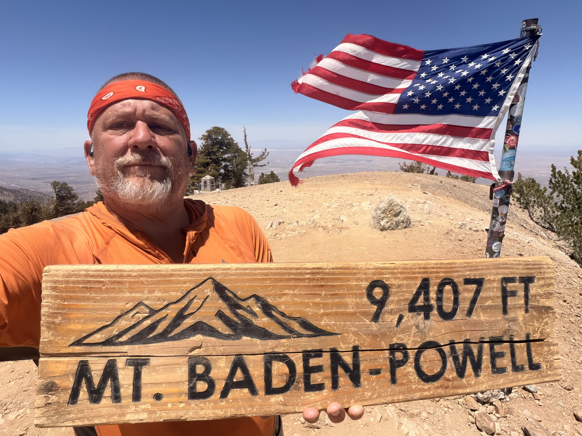
Named for the founder of Scouting, Mount Baden-Powell is one of the more popular peaks on a side trail from the Pacific Crest Trail. At 9,406 feet (2,867 meters), it is the fourth highest peak in the San Gabriel Mountains. If you look carefully, and the smog is not too bad, you can see the downtown Los Angeles skyline.
We started our ascent of Baden Powell at 10:20. It’s steep even with switchbacks. We sat on a very well-placed wooden bench at 1 mile up and admired the view.

Looking up into a monster tree around the 1-mile mark.
We stopped for water at Lamel Spring about 1.7 miles into the ascent. Last water until the late afternoon.

We summited at 12:50 and 8.79 miles. The summit is at 9,407 feet. We hiked uphill 3,414 feet so far today. It was hard, but much less so than we expected. We are getting our trail legs.
Amazing views. And fair cell service. Very cool experience and a bit emotional. We hung out for about 45 minutes soaking in the views and the experience.


YouTube video from summit of Mount Baden Powell.
Shoutout to my Big Brother, Jon Luning, for getting a custom mini Theta Xi Fraternity flag made for me. This is the first major milestone on the PCT where I got to display the flag. Thanks, brother.


We had about 15 minutes with the summit to ourselves before a bunch of others arrived.


We left the summit and started our 9-mile hike to water and our camp for the night. Fairly pleasant with a few big ups but mostly chill terrain and views west to LA and north to the Mojave Desert. Great view of Edwards AFB in the distance all afternoon.
We stopped for 5 liters of water at Little Jimmy Spring followed a 2.8-mile carry. No water at camp and none for 10.3 more miles. Surprisingly, my body easily carried that load this time!

The last 2.5 miles was through a large burn area and landslide area. We finally encountered Poodle Dog Bush. This nasty plant is worse than poison oak and has a sticky resin all over that stings and burns badly for days. It thrives in old burn areas. It was everywhere this afternoon in the burn areas. Right up to the trail in places.

We got to a rest stop on Hwy 2 about .5 miles before the road is closed. It’s like a different world up here as everything had been unused since last fall. Nobody comes up here now as this part of the road is very remote in normal times. Just construction traffic and none of that this late in the day.

We walked up the abandoned highway .3 miles to a roadside picnic area at 6:45 and 18 miles. Clean pit toilet, trash can, picnic table, and an amazing view southwest towards LA.
YouTube video of road walk abandoned Hwy 2.


Made camp and ate dinner watching an awesome sunset. It got cold the second after that sun dipped behind the mountains.

As I expected, once it got dark, we had an outstanding view down onto the lights of LA. I stared at the lights for quite a while. Still photos don’t work, so I took a so-so video from inside my tent of the LA lights. We are camped at 6,800 feet and are about 40 miles from LA. The closest areas from us are Pasadena and Anaheim straight south.

YouTube video of the lights of LA.
Today was a great day. Big hard climb and a 5-liter water carry, and I felt great. Summiting Baden Powell in good weather is not all that common, and it has long been one of my key side quests on the PCT. It really makes me feel alive on days like this. And finish out the day with the cool view of the LA lights, wow!

Technical Notes:
- Banana Chips (18p, 30g): 150 kcal, 20g carb, 8g fat, 1g protein
- Banana Chips (18p, 30g): 150 kcal, 20g carb, 8g fat, 1g protein
- Skittles (2.17oz): 250 kcal, 56g carb, 2.5g fat, 0g protein
- Fatty Beef Stick 150, 1.5g carb, 11.5g fat, 10g protein
- Mango (3-4p, 49g): 140 kcal, 35g carb, 0g fat, 0g protein
- Skittles (2.17oz): 250 kcal, 56g carb, 2.5g fat, 0g protein
- Peak Refuel Curry Chicken: 850 kcal, 65g carb, 44g fat
- Jerky (2 oz): 140 kcal, 12g carb, 0g fat, 22g protein
- Fritos (32p, 27g): 160 kcal, 16g carb, 10g fat, 2g protein
- Fritos (32p, 27g): 160 kcal, 16g carb, 10g fat, 2g protein
- Water liters: 4
- Miles: 17.8
- Time: 10:33
- Up: 4347
- Down: 4951
- Calories consumed: 2460
- Calories burned: 4193
- iPhone battery used: 70%
Leave a Reply